Sangeang Api
Indonesia
8.2°S, 119.07°E; summit elev. 1912 m
All times are local (unless otherwise noted)
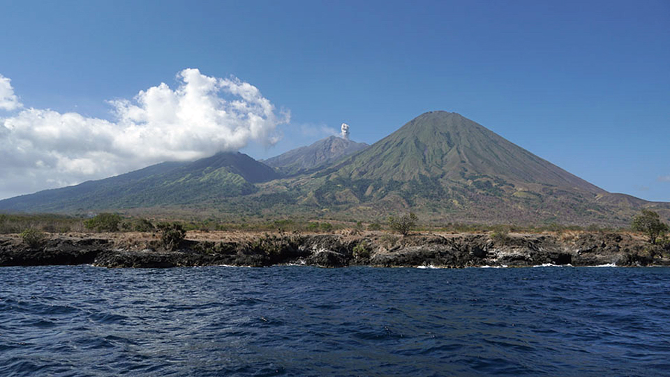
Sangeang Api is a small 13-km-wide island volcano off the NE coast of Sumbawa Island, part of Indonesia's Lesser Sunda Islands. Intermittent historical eruptions have been recorded since 1512, most of them during in the 20th century. Ash plumes, Strombolian activity and pyroclastic and lava flows during 1985-1987 from the Doro Api summit crater were the first activity in 20 years and led to the evacuation of over 1,200 residents on the island. Explosive activity resumed for about two years during 1997-1999; no further activity was reported until increased seismicity and white emissions were noted in mid-2009. This activity was intermittent from 2009 through early 2014.
On 30 and 31 May 2014, Pusat Vulkanologi dan Mitigasi Bencana Geologi (PVMBG, or CVGHM) reported large explosions with ash plumes that rose to around 15 km altitude and pyroclastic flows down the flanks (BGVN 39:03, 41:10). The massive ash plume drifted SE, closing airports as far away as Darwin, Australia. The ashfall caused airline disruption and evacuation of thousands in villages on nearby Sumbawa Island. Strong thermal anomalies appeared after the explosions and lasted for the rest of 2014, indicative of flow activity down the E flank; mostly steam plumes, with occasional ash emissions were reported during 2015. Renewed thermal activity appeared in satellite data in mid-January 2017. The thermal signature increased through July 2017 when Strombolian activity and ash emissions were reported (BGVN 42:09). A high level of thermal activity continued through October 2018, with satellite imagery confirming incandescent activity on the E flank, and PVMBG reporting ash emissions that rose a few kilometers above the summit (BGVN 43:11).
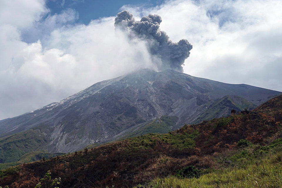
During October 2018-April 2019, covered in this report, elevated thermal activity was recorded with satellite data and imagery, and visitors to the island recorded ash plumes, Strombolian activity, lava bombs, and a blocky avalanche flow down the E flank from the pyroclastic cone inside Doro Api cone. Information comes from satellite thermal data and imagery, and reports from visitors to the island. Indonesia's Pusat Vulkanologi dan Mitigasi Bencana Geologi (PVMBG) listed Sangeang Api at Alert Level II for the period. There were no reports from the Darwin VAAC.
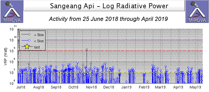
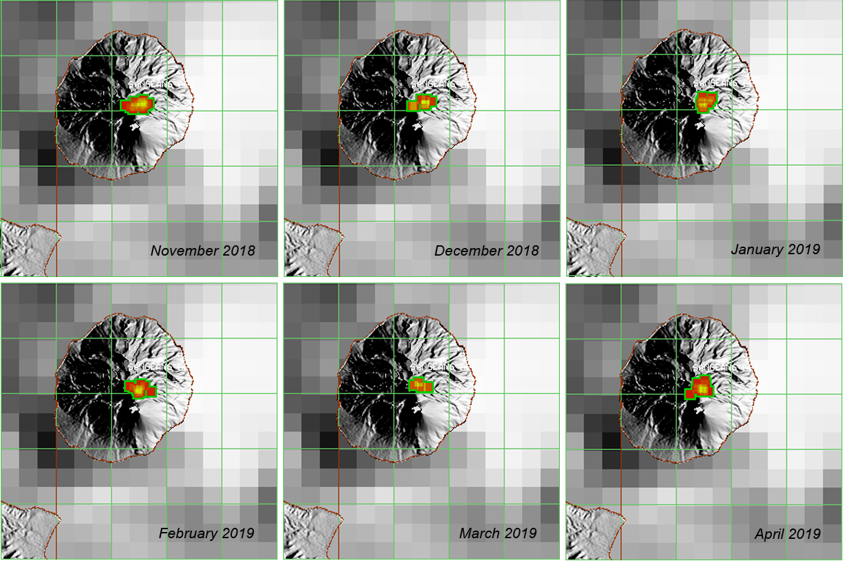
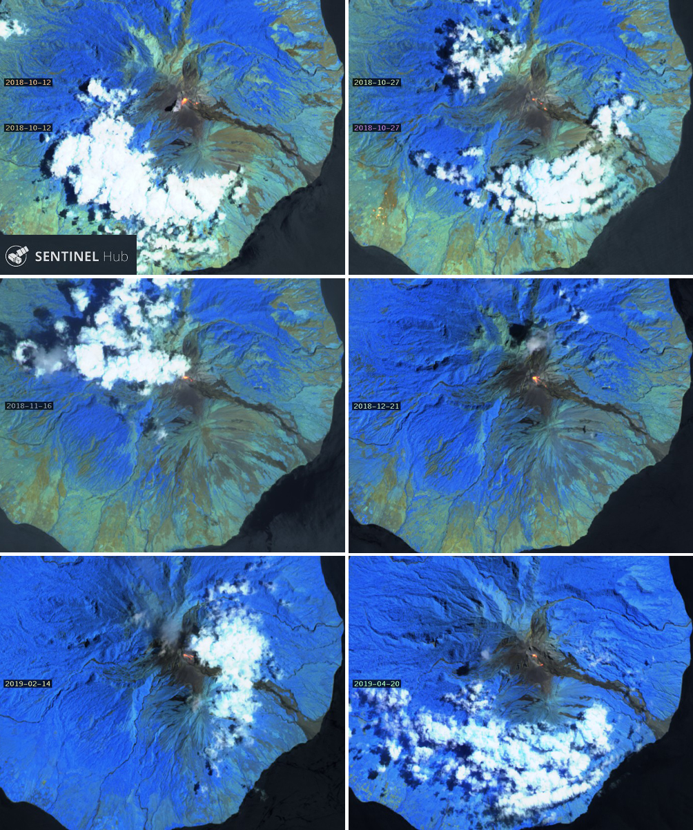
Thermal activity became more intermittent during December 2018-March 2019 compared with the previous six months, and then increased again in April according to the MIROVA project thermal data (figure 20). The MODVOLC thermal alerts showed a similar pattern, with a decrease in the number of monthly alerts during December through March. In spite of this, a strong thermal signal was still apparent near the summit throughout the period (figure 21). Sentinel-2 satellite images confirmed the presence of hot material at the summit and down the E-flank ravine throughout the period (figure 22).
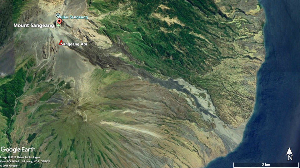
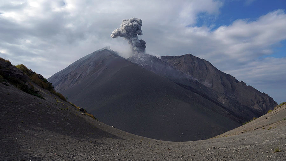
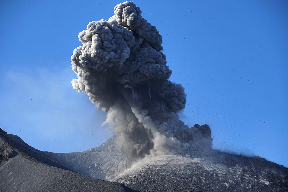
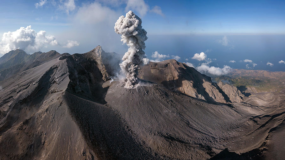
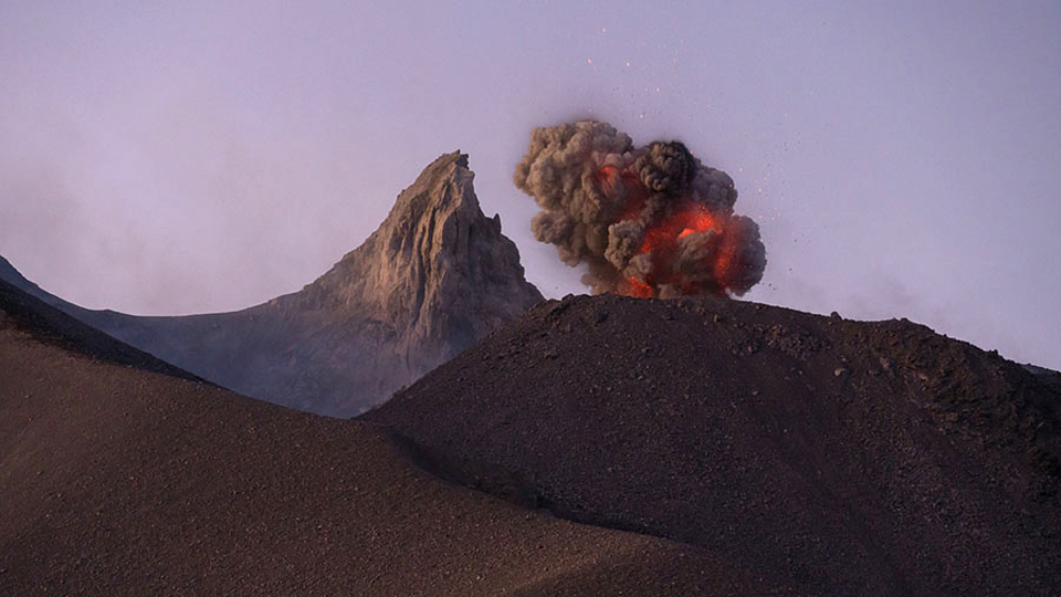
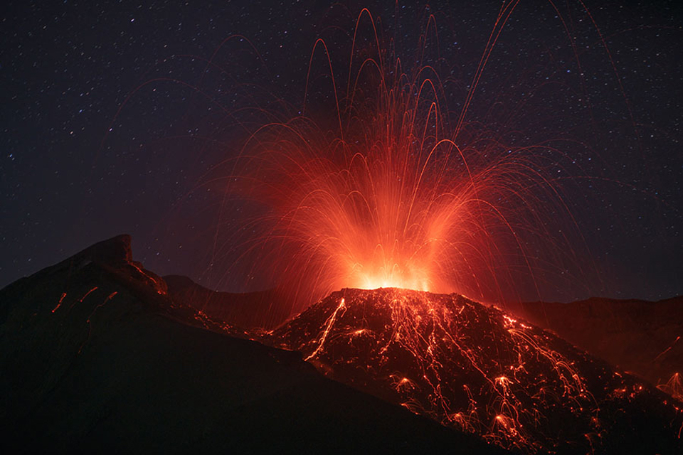
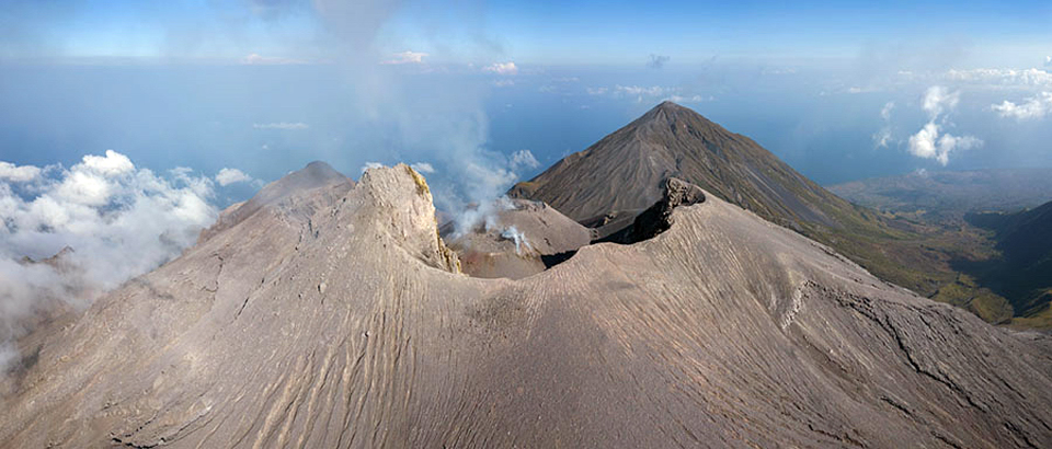
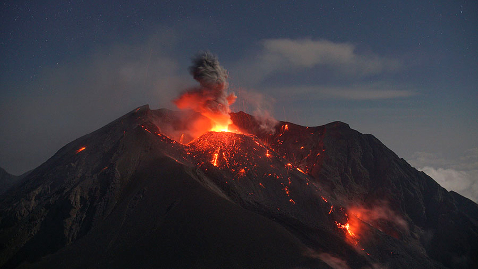
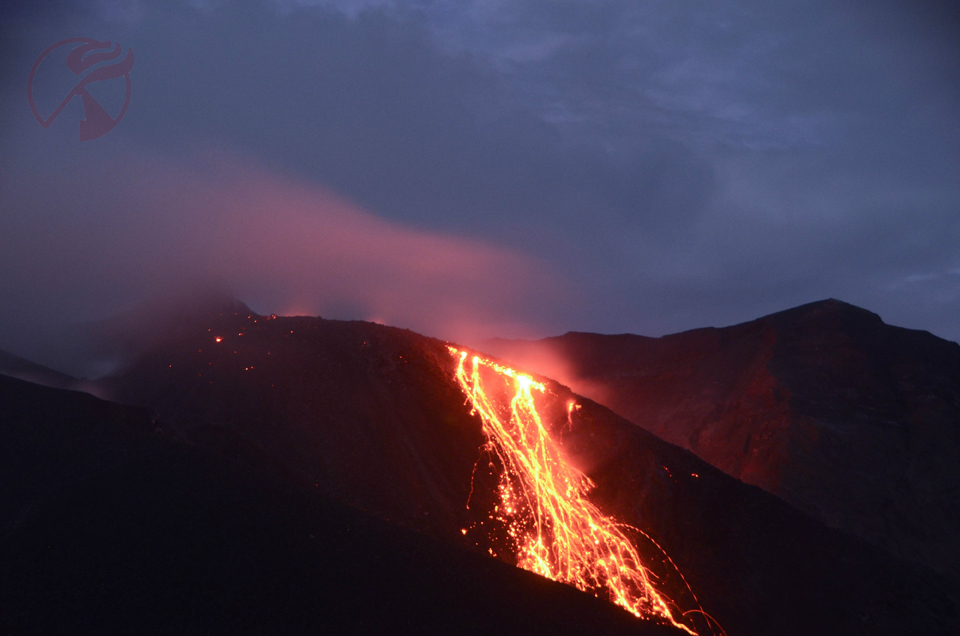
A Google Earth image dated 7 October 2018 shows dark lava in the drainage on the SE flank extending to within 1 km of the shoreline (figure 23). A visit to Sangeang Api by photographer Martin Rietze during 25 September-3 October 2018 provided excellent ground and drone-based photographic and video documentation of the eruptive activity at that time (see information contacts for link to video footage). Regular small ash emissions were recorded multiple times per day from a pyroclastic cone inside the Doro Api cone (figure 24); the explosions produced volcanic bombs that traveled hundreds of meters down the flanks of Doro Api (figure 25) as well as sending lava fragments down all sides of the pyroclastic cone (figures 26 and 27). Steam and ash rose a few hundred meters above the summit of the pyroclastic cone and was incandescent after dark (figures 28 and 29).
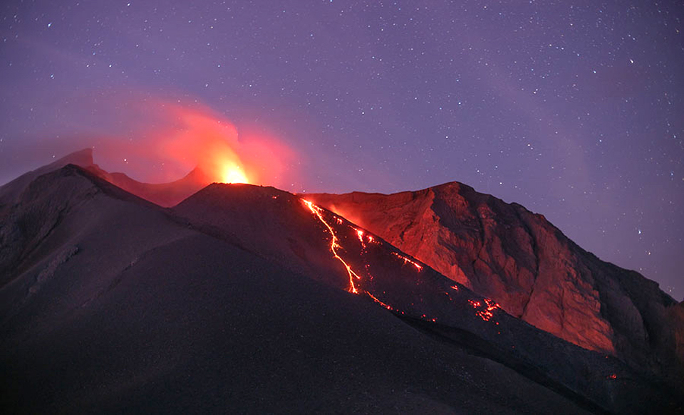
Incandescent bombs and blocks from Strombolian activity cascaded down the flanks of the pyroclastic cone and also reached outside of the Doro Api crater, landing on the W flank (figures 30 and 31). Steaming tephra on the flanks of the pyroclastic cone was visible during daylight hours (figure 32); the active Doro Api cone is near the center of the island, the inactive Doro Mantai is on the SE flank. In a nighttime view of Doro Api as seen from the summit of Doro Mantai, the incandescent ejecta is clearly visible hundreds of meters from the erupting pyroclastic cone (figure 33). Video footage showed incandescent lava emerging from a fissure near the base of the pyroclastic cone, and a blocky avalanche on the E flank of the cone; as blocks rolled down the slope, incandescence was visible just below the surface.
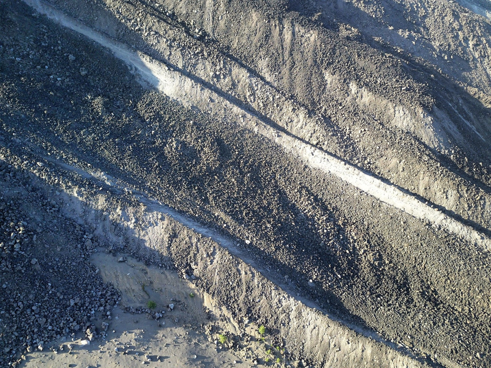
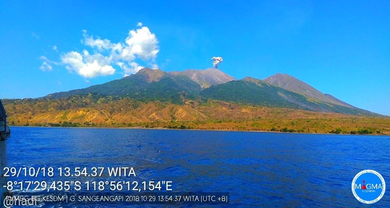
Blocks of lava formed an avalanche down the ravine on the E flank of Doro Api; the avalanche formed channels tens of meters wide on the steep slope (figure 34) when photographed by drone in early October 2018. The PVMBG webcam located on nearby Sumbawa island about 10 km SW captured an image of a small ash emission rising from the Doro Api summit in late October (figure 35). Visitors to the island in November recorded continued activity in the form of ash plumes and incandescent lava emerging from a fissure on the flank of the pyroclastic cone (figure 36).
Geological Summary. Sangeang Api volcano, one of the most active in the Lesser Sunda Islands, forms a small 13-km-wide island off the NE coast of Sumbawa Island. Two large trachybasaltic-to-tranchyandesitic volcanic cones, Doro Api and Doro Mantoi, were constructed in the center and on the eastern rim, respectively, of an older, largely obscured caldera. Flank vents occur on the south side of Doro Mantoi and near the northern coast. Intermittent eruptions have been recorded since 1512, most of them during in the 20th century.
Information Contacts: Pusat Vulkanologi dan Mitigasi Bencana Geologi (PVMBG, also known as Indonesian Center for Volcanology and Geological Hazard Mitigation, CVGHM), Jalan Diponegoro 57, Bandung 40122, Indonesia (URL: http://www.vsi.esdm.go.id/); MAGMA Indonesia, Kementerian Energi dan Sumber Daya Mineral (URL: https://magma.vsi.esdm.go.id/); MIROVA (Middle InfraRed Observation of Volcanic Activity), a collaborative project between the Universities of Turin and Florence (Italy) supported by the Centre for Volcanic Risk of the Italian Civil Protection Department (URL: http://www.mirovaweb.it/); Hawai'i Institute of Geophysics and Planetology (HIGP) - MODVOLC Thermal Alerts System, School of Ocean and Earth Science and Technology (SOEST), Univ. of Hawai'i, 2525 Correa Road, Honolulu, HI 96822, USA (URL: http://modis.higp.hawaii.edu/); Google Earth (URL: https://www.google.com/earth/); Sentinel Hub Playground (URL: https://www.sentinel-hub.com/explore/sentinel-playground); Martin Rietze, Taubenstr. 1, D-82223 Eichenau, Germany (URL: https://mrietze.com/, Videos at https://www.youtube.com/channel/UC5LzAA_nyNWEUfpcUFOCpJw/videos); Øystein Lund Andersen (Twitter: @OysteinLAnderse, https://twitter.com/OysteinLAnderse, URL: http://www.oysteinlundandersen.com); 80 Jours Voyages, Lyon, France (Twitter: https://twitter.com/jours_80, URL: https://80joursvoyages.com/); Doro Adventures (Twitter: https://twitter.com/DoroAdventures, URL: http://doroadventures.com/).