Report on Ubinas (Peru) — September 2019

Bulletin of the Global Volcanism Network, vol. 44, no. 9 (September 2019)
Managing Editor: Edward Venzke.
Research and preparation by Paul Berger.
Ubinas (Peru) Intermittent ash explosions in June-August 2019
Please cite this report as:
Global Volcanism Program, 2019. Report on Ubinas (Peru) (Venzke, E., ed.). Bulletin of the Global Volcanism Network, 44:9. Smithsonian Institution. https://doi.org/10.5479/si.GVP.BGVN201909-354020
Ubinas
Peru
16.345°S, 70.8972°W; summit elev. 5608 m
All times are local (unless otherwise noted)
Prior to renewed activity in June 2019, the most recent eruptive episode at Ubinas occurred between 13 September 2016 and 2 March 2017, with ash explosions that generated plumes that rose up to 1.5-2 km above the summit crater (BGVN 42:10). The volcano remained relatively quiet between April 2017 and May 2019. This report discusses an eruption that began in June 2019 and continued through at least August 2019. Most of the Information was provided by the Instituto Geofísico del Perú (IGP), Observatoria Vulcanologico del Sur (IGP-OVS), the Observatorio Volcanológico del INGEMMET (Instituto Geológical Minero y Metalúrgico) (OVI-INGEMMET), and the Buenos Aires Volcanic Ash Advisory Center (VAAC).
Activity during June 2019. According to IGP, seismic activity increased suddenly on 18 June 2019 with signals indicating rock fracturing. During 21-24 June, signals indicating fluid movement emerged and, beginning at 0700 on 24 June, webcams recorded ash, gas, and steam plumes rising from the crater. Plumes were visible in satellite images rising to an altitude of 6.1 km and drifting N, NE, and E.
IGP and INGEMMET reported that seismic activity remained elevated during 24-30 June; volcano-tectonic (VT) events averaged 200 per day and signals indicating fluid movement averaged 38 events per day. Emissions of gas, water vapor, and ash rose from the crater and drifted N and NE, based on webcam views and corroborated with satellite data. According to a news article, a plume rose 400 m above the crater rim and drifted 10 km NE. Weather clouds often obscured views of the volcano, but an ash plume was visible in satellite imagery on 24 June 2019 (figure 49). On 27 June the Alert Level was raised to Yellow (second lowest on a 4-level scale).
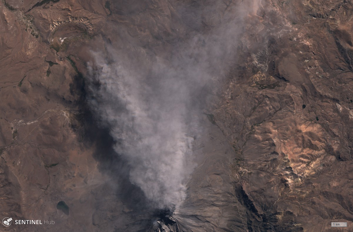 |
Figure 49. Sentinel-2 satellite image in natural color showing an ash plume blowing north from Ubinas on 24 June 2019. Courtesy of Sentinel Hub Playground. |
Activity during July 2019. IGP reported that seismic activity remained elevated during 1-15 July; VT events averaged 279 per day and long-period (LP) events (indicating fluid movement) averaged 116 events per day. Minor bluish emissions (magmatic gas) rose from the crater. Infrared imagery obtained by Sentinel-2 first showed a hotspot in the summit crater on 4 July.
According to IGP, during 17-19 July, gas-and-ash emissions occasionally rose from Ubinas's summit crater and drifted N, E, and SE. Beginning at 0227 on 19 July, as many as three explosions (two were recorded at 0227 and 0235) generated ash plumes that rose to 5.8 km above the crater rim. The Buenos Aires VAAC reported that, based on satellite images, ash plumes rose to an altitude as high as 12 km. The Alert Level was raised to Orange and the public were warned to stay beyond a 15-km radius. Ash plumes drifted as far as 250 km E and SE, reaching Bolivia. Ashfall was reported in areas downwind, including the towns of Ubinas (6.5 km SSE), Escacha, Anascapa (11 km SE), Tonohaya (7 km SSE), Sacohaya, San Miguel (10 km SE), Huarina, and Matalaque, causing some families to evacuate. The Buenos Aires VAAC reported that during 20-23 July ash plumes rose to an altitude of 7.3-9.5 km and drifted E, ESE, and SE.
IGP reported that activity remained elevated after the 19 July explosions. A total of 1,522 earthquakes, all with magnitudes under 2.2, were recorded during 20-24 July. Explosions were detected at 0718 and 2325 on 22 July, the last ones until 3 September. The Buenos Aires VAAC reported that an ash plume rising to an altitude of 9.4 km. and drifting SE was identified in satellite data at 0040 on 22 July (figure 50). Continuous steam-and-gas emissions with sporadic pulses of ash were visible in webcam views during the rest of the day. Ash emissions near the summit crater were periodically visible on 24 July though often partially hidden by weather clouds. Ash plumes were visible in satellite images rising to an altitude of 7 km. Diffuse ash emissions near the crater were visible on 25 July, and a thermal anomaly was identified in satellite images. During 26-28 July, there were 503 people evacuated from areas affected by ashfall.
 |
Figure 50. Image of ash streaming from the summit of Ubinas on 22 July 2019 captured by the Moderate Resolution Imaging Spectroradiometer (MODIS) on NASA's Terra satellite. Courtesy of NASA's Earth Observatory (Joshua Stevens and Kathryn Hansen). |
Activity during August 2019. IGP reported that during 13-19 August blue-colored gas plumes rose to heights of less than 1.5 km above the base of the crater. The number of seismic events was 1,716 (all under M 2.4), a decrease from the total recorded the previous week.
According to IGP, blue-colored gas plumes rose above the crater and eight thermal anomalies were recorded by the MIROVA system during 20-26 August. The number of seismic events was 1,736 (all under M 2.4), and there was an increase in the magnitude and number of hybrid and LP events. Around 1030 on 26 August an ash emission rose less than 2 km above the crater rim. Continuous ash emissions on 27 August were recorded by satellite and webcam images drifting S and SW.
IGP reported that during the week of 27 August, gas-and-water-vapor plumes rose to heights less than 1 km above the summit. The number of seismic events was 2,828 (all under M 2.3), with VT signals being the most numerous. There was a slight increase in the number of LP, hybrid, and VT events compared to the previous week. The Alert Level remained at Orange.
Thermal anomalies. The MIROVA (Middle InfraRed Observation of Volcanic Activity) system detected a large concentration of anomalies between 19 July until almost the end of August 2019, all of which were of low radiative power (figure 51). Infrared satellite imagery (figure 52) also showed the strong thermal anomaly associated with the explosive activity on 19 July and then the continuing hot spot inside the crater through the end of August.
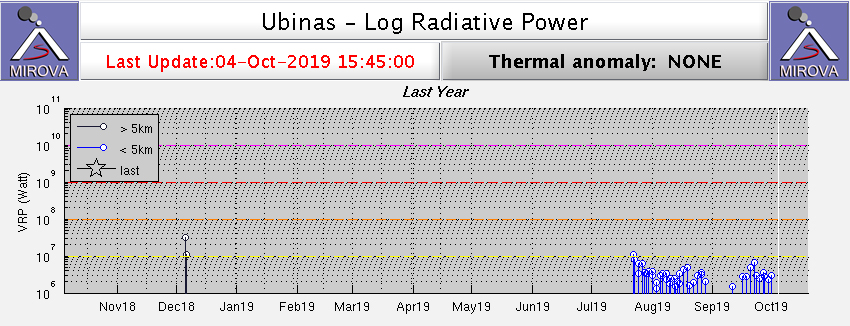 |
Figure 51. Log radiative power MIROVA plot of MODIS thermal anomalies at Ubinas for the year ending on 4 October 2019. Thermal activity began in the second half of July. Courtesy of MIROVA. |
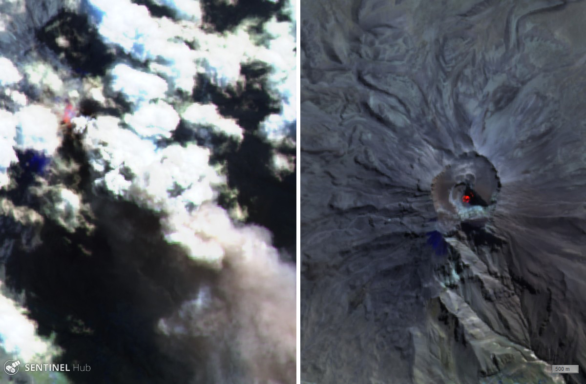 |
Figure 52. Sentinel-2 satellite images (Atmospheric penetration rendering, bands 12, 11, 8A) showing thermal anomalies during the eruption on 19 July (left) and inside the summit crater on 29 July 2019 (right). A hot spot inside the crater persisted through the end of August. Courtesy of Sentinel Hub Playground. |
Geological Summary. The truncated appearance of Ubinas, Perú's most active volcano, is a result of a 1.4-km-wide crater at the summit. It is the northernmost of three young volcanoes located along a regional structural lineament about 50 km behind the main volcanic front. The growth and destruction of Ubinas I was followed by construction of Ubinas II beginning in the mid-Pleistocene. The upper slopes of the andesitic-to-rhyolitic Ubinas II stratovolcano are composed primarily of andesitic and trachyandesitic lava flows and steepen to nearly 45°. The steep-walled, 150-m-deep summit crater contains an ash cone with a 500-m-wide funnel-shaped vent that is 200 m deep. Debris-avalanche deposits from the collapse of the SE flank about 3,700 years ago extend 10 km from the volcano. Widespread Plinian pumice-fall deposits include one from about 1,000 years ago. Holocene lava flows are visible on the flanks, but activity documented since the 16th century has consisted of intermittent minor-to-moderate explosive eruptions.
Information Contacts: Instituto Geofisico del Peru (IGP), Observatoria Vulcanologico del Sur (IGP-OVS), Arequipa Regional Office, Urb La Marina B-19, Cayma, Arequipa, Peru (URL: http://ovs.igp.gob.pe/); Observatorio Volcanologico del INGEMMET (Instituto Geológical Minero y Metalúrgico), Barrio Magisterial Nro. 2 B-16 Umacollo - Yanahuara Arequipa (URL: http://ovi.ingemmet.gob.pe); Buenos Aires Volcanic Ash Advisory Center (VAAC), Servicio Meteorológico Nacional-Fuerza Aérea Argentina, 25 de mayo 658, Buenos Aires, Argentina (URL: http://www.smn.gov.ar/vaac/buenosaires/inicio.php?lang=es); MIROVA (Middle InfraRed Observation of Volcanic Activity), a collaborative project between the Universities of Turin and Florence (Italy) supported by the Centre for Volcanic Risk of the Italian Civil Protection Department (URL: http://www.mirovaweb.it/); Sentinel Hub Playground (URL: https://www.sentinel-hub.com/explore/sentinel-playground); Instituto Nacional de Defensa Civil Perú (INDECI) (URL: https://www.indeci.gob.pe/); Gobierno Regional de Moquegua (URL: http://www.regionmoquegua.gob.pe/web13/); La Republica (URL: https://larepublica.pe/); NASA Earth Observatory, EOS Project Science Office, NASA Goddard Space Flight Center, Goddard, Maryland, USA (URL: http://earthobservatory.nasa.gov/).