Report on Krakatau (Indonesia) — February 2020

Bulletin of the Global Volcanism Network, vol. 45, no. 2 (February 2020)
Managing Editor: Edward Venzke.
Edited by A. Elizabeth Crafford.
Krakatau (Indonesia) Tephra and steam explosions in the crater lake; explosions in December 2019 build a tephra cone
Please cite this report as:
Global Volcanism Program, 2020. Report on Krakatau (Indonesia) (Crafford, A.E., and Venzke, E., eds.). Bulletin of the Global Volcanism Network, 45:2. Smithsonian Institution. https://doi.org/10.5479/si.GVP.BGVN202002-262000
Krakatau
Indonesia
6.1009°S, 105.4233°E; summit elev. 285 m
All times are local (unless otherwise noted)
Krakatau volcano in the Sunda Strait between Indonesia’s Java and Sumatra Islands experienced a major caldera collapse around 535 CE; it formed a 7-km-wide caldera ringed by three islands. Remnants of this volcano joined to create the pre-1883 Krakatau Island which collapsed during the major 1883 eruption. Anak Krakatau (Child of Krakatau), constructed beginning in late 1927 within the 1883 caldera (BGVN 44:03, figure 56), was the site of over 40 eruptive episodes until 22 December 2018 when a large explosion and flank collapse destroyed most of the 338-m-high edifice and generated a deadly tsunami (BGVN 44:03). The near-sea level crater lake inside the remnant of Anak Krakatau was the site of numerous small steam and tephra explosions from February (BGVN 44:08) through November 2019. A larger explosion in December 2019 produced the beginnings of a new cone above the surface of crater lake. Activity from August 2019 through January 2020 is covered in this report with information provided by the Indonesian Center for Volcanology and Geological Hazard Mitigation, referred to as Pusat Vulkanologi dan Mitigasi Bencana Geologi (PVMBG). Aviation reports are provided by the Darwin Volcanic Ash Advisory Center (VAAC), and photographs are from the PVMBG webcam and visitors to the island.
Explosions were reported on more than ten days each month from August to October 2019. They were recorded based on seismicity, but webcam images also showed black tephra and steam being ejected from the crater lake to heights up to 450 m. Activity decreased significantly after the middle of November, although smaller explosions were witnessed by visitors to the island. After a period of relative quiet, a larger series of explosions at the end of December produced ash plumes that rose up to 3 km above the crater; the crater lake was largely filled with tephra after these explosions. Thermal activity persisted throughout the period of August 2019-January 2020. The wattage of Radiative Power increased from August through mid-October, and then decreased through January 2020 (figure 96).
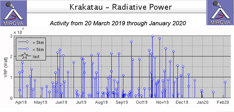 |
Figure 96. Thermal activity persisted at Anak Krakatau from 20 March 2019-January 2020. The wattage of Radiative Power increased from August through mid-October, and then decreased through January 2020. Courtesy of MIROVA. |
Activity during August-November 2019. The new profile of Anak Krakatau rose to about 155 m elevation as of August 2019, almost 100 m less than prior to the December 2018 explosions and flank collapse (figure 97). Smaller explosions continued during August 2019 and were reported by PVMBG in 12 different VONAs (Volcano Observatory Notice to Aviation) on days 1, 3, 6, 17, 19, 22, 23, 25, and 28. Most of the explosions lasted for less than two minutes, according to the seismic data. PVMBG reported steam plumes of 25-50 m height above the sea-level crater on 20 and 21 August. They reported a visible ash cloud on 22 August; it rose to an altitude of 457 m and drifted NNE according to the VONA. In their daily update, they noted that the eruption plume of 250-400 m on 22 August was white, gray, and black. The Darwin VAAC reported that the ash plume was discernable on HIMAWARI-8 satellite imagery for a short period of time. PVMBG noted ten eruptions on 24 August with white, gray, and black ejecta rising 100-300 m. A webcam installed at month’s end provided evidence of diffuse steam plumes rising 25-150 m above the crater during 28-31 August.
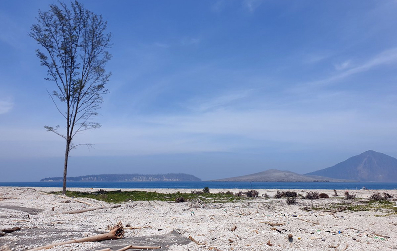 |
Figure 97. Only one tree survived on the once tree-covered spit off the NE end of Sertung Island after the December 2018 tsunami from Anak Krakatau covered it with ash and debris. The elevation of Anak Krakatau (center) was about 155 m on 8 August 2019, almost 100 m less than before the explosions and flank collapse. Panjang Island is on the left, and 746-m-high Rakata, the remnant of the 1883 volcanic island, is behind Anak Krakatau on the right. Courtesy of Amber Madden-Nadeau. |
VONAs were issued for explosions on 1-3, 11, 13, 17, 18, 21, 24-27 and 29 September 2019. The explosion on 2 September produced a steam plume that rose 350 m, and dense black ash and ejecta which rose 200 m from the crater and drifted N. Gray and white tephra and steam rose 450 m on 13 and 17 September; ejecta was black and gray and rose 200 m on 21 September (figure 98). During 24-27 and 29 September tephra rose at least 200 m each day; some days it was mostly white with gray, other days it was primarily gray and black. All of the ejecta plumes drifted N. On days without explosions, the webcam recorded steam plumes rising 50-150 m above the crater.
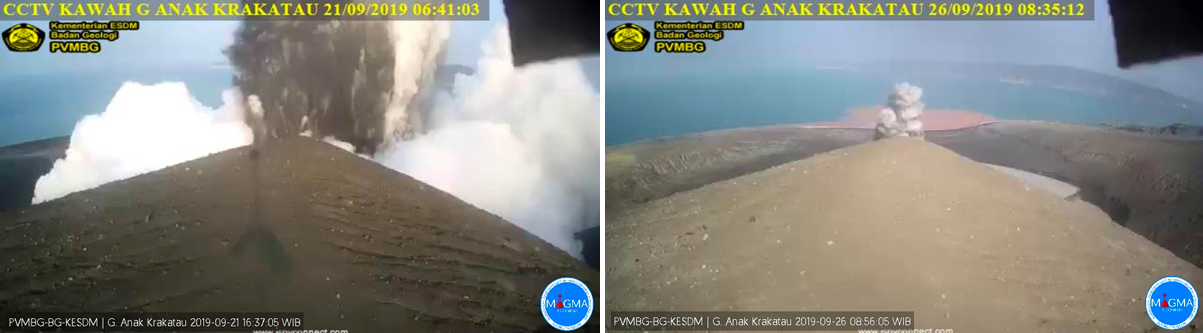 |
Figure 98. Explosions of steam and dark ejecta were captured by the webcam on Anak Krakatau on 21 (left) and 26 (right) September 2019. Courtesy of MAGMA Indonesia and PVMBG. |
Explosions were reported daily during 12-14, 16-20, 25-27, and 29 October (figure 99). PVMBG reported eight explosions on 19 October and seven explosions the next day. Most explosions produced gray and black tephra that rose 200 m from the crater and drifted N. On many of the days an ash plume also rose 350 m from the crater and drifted N. The seismic events that accompanied the explosions varied in duration from 45 to 1,232 seconds (about 20 minutes). The Darwin VAAC reported the 12 October eruption as visible briefly in satellite imagery before dissipating near the volcano. The first of four explosions on 26 October also appeared in visible satellite imagery moving NNW for a short time. The webcam recorded diffuse steam plumes rising 25-150 m above the crater on most days during the month.
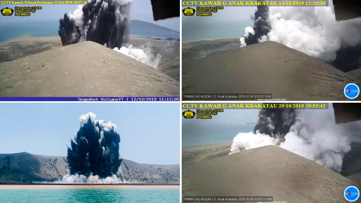 |
Figure 99. A number of explosions at Anak Krakatau were captured by the webcam and visitors near the island during October 2019, shown here on the 12th, 14th, 17th, and 29th. Black and gray ejecta and steam plumes jetted several hundred meters high from the crater lake during the explosions. Webcam images courtesy of PVMBG and MAGMA Indonesia, with 12 October 2019 (top left) via VolcanoYT. Bottom left photo on 17 October courtesy of Christoph Sator. |
Five VONAs were issued for explosions during 5-7 November, and one on 13 November 2019. The three explosions on 5 November produced 200-m-high plumes of steam and gray and black ejecta and ash plumes that rose 200, 450, and 550 m respectively; they all drifted N (figure 100). The Darwin VAAC reported ash drifting N in visible imagery for a brief period also. A 350-m-high ash plume accompanied 200-m-high ejecta on 6 November. Tephra rose 150-300 m from the crater during a 43 second explosion on 7 November. The explosion reported by PVMBG on 13 November produced black tephra and white steam 200 m high that drifted N. For the remainder of the month, when not obscured by fog, steam plumes rose daily 25-150 m from the crater.
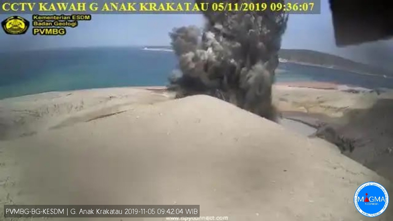 |
Figure 100. PVMBG’s KAWAH webcam captured an explosion with steam and dark ejecta from the crater lake at Anak Krakatau on 5 November 2019. Courtesy of PVMBG and MAGMA Indonesia. |
A joint expedition with PVMBG and the Earth Observatory of Singapore (EOS) installed geophysical equipment on Anak Krakatau and Rakata during 12 and 13 November 2019 (figure 101). Visitors to the island during 19-23 and 22-24 November recorded the short-lived landscape and continuing small explosions of steam and black tephra from the crater lake (figures 102 and 103).
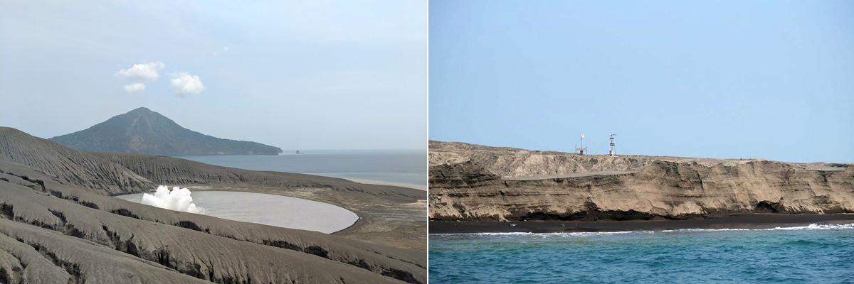 |
Figure 101. A joint expedition to Anak Krakatau with PVMBG and the Earth Observatory of Singapore (EOS) installed geophysical equipment on Anak Krakatau and Rakata (background, left) during 12 and 13 November 2019. Images of the crater lake from the same spot (left) in December and January show the changes at the island (figure 108). Monitoring equipment installed near the shore sits over the many layers of ash and tephra that make up the island (right). Courtesy of Anna Perttu. |
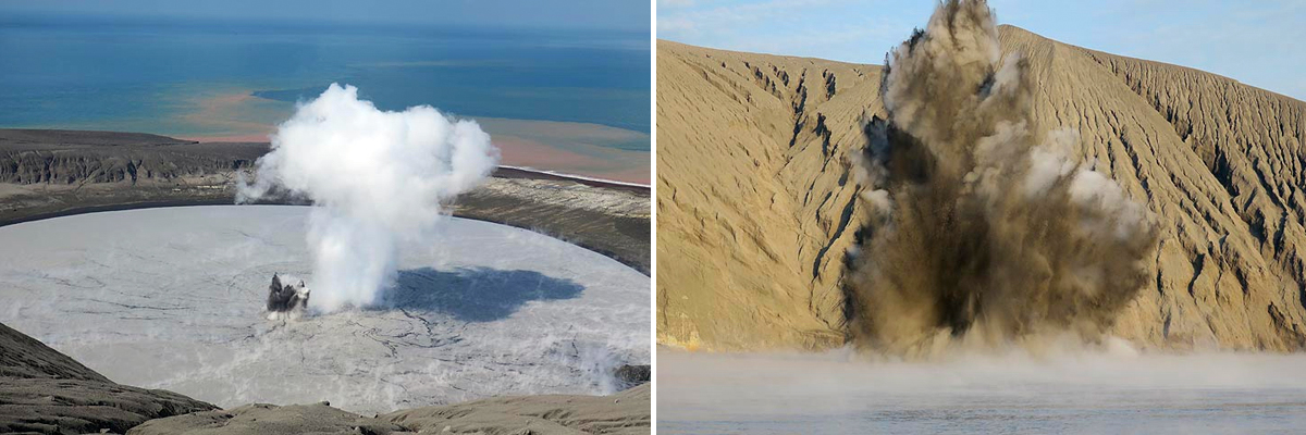 |
Figure 102.The crater lake at Anak Krakatau during a 19-23 November 2019 visit was the site of continued explosions with jets of steam and tephra that rose as high as 30 m. Courtesy of Andrey Nikiforov and Volcano Discovery, used with permission. |
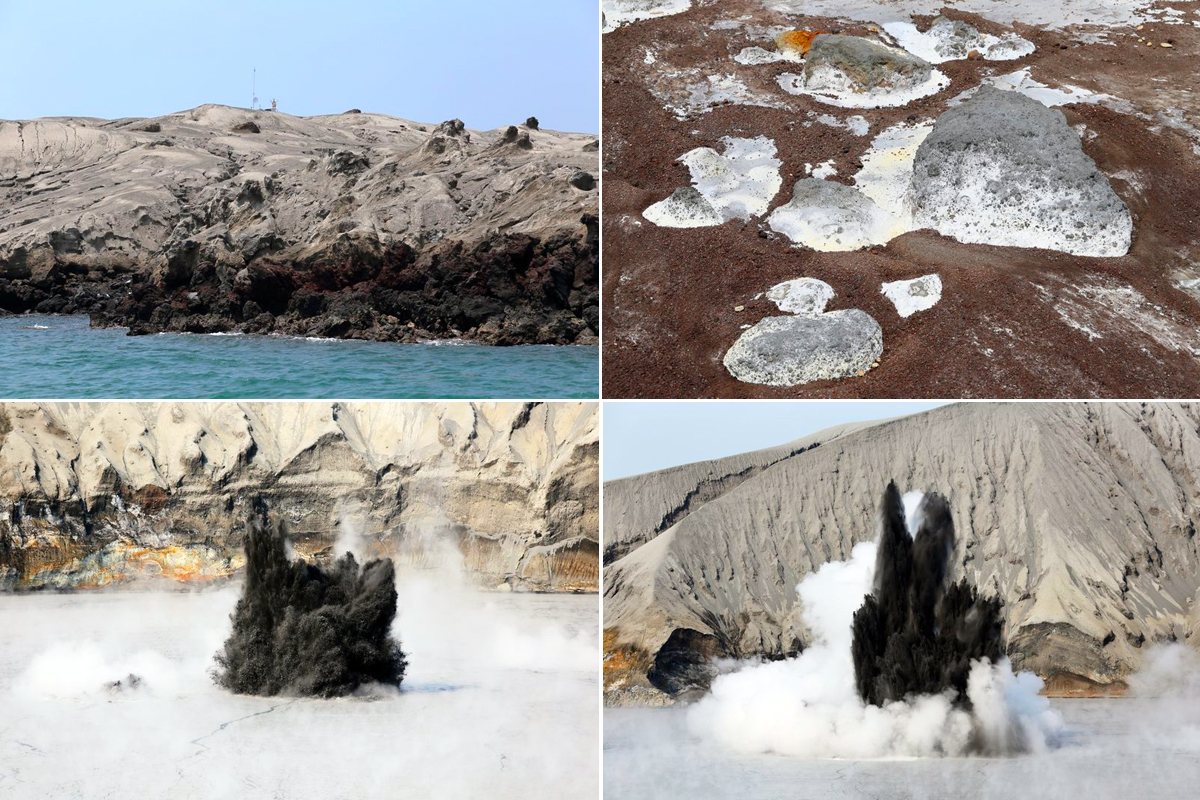 |
Figure 103. The landscape of Anak Krakatau recorded the rapidly evolving sequence of volcanic events during November 2019. Fresh ash covered recent lava near the shoreline on 22 November 2019 (top left). Large blocks of gray tephra (composed of other tephra fragments) were surrounded by reddish brown smaller fragments in the area between the crater and the ocean on 23 November 2019 (top right). Explosions of steam and black tephra rose tens of meters from the crater lake on 23 November 2019 (bottom). Courtesy of and copyright by Pascal Blondé. |
Activity during December 2019-January 2020. Very little activity was recorded for most of December 2019. The webcam captured daily images of diffuse steam plumes rising 25-50 m above the crater which occasionally rose to 150 m. A new explosion on 28 December produced black and gray ejecta 200 m high that drifted N; the explosion was similar to those reported during August-November. A new series of explosions from 30 December 2019 to 1 January 2020 produced ash plumes which rose significantly higher than the previous explosions, reaching 2.4-3.0 km altitude and drifting S, E, and SE according to PVMBG (figure 104). They were initially visible in satellite imagery and reported drifting SW by the Darwin VAAC. By 31 December meteorological clouds prevented observation of the ash plume but a hotspot remained visible for part of that day.
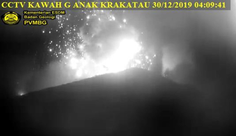 |
Figure 104.The KAWAH webcam at Anak Krakatau captured this image of incandescent ejecta exploding from the crater lake on 30 December 2019 near the start of a new sequence of large explosions. Courtesy of PVMBG and Alex Bogár. |
The explosions on 30 and 31 December 2019 were captured in satellite imagery (figure 105) and appeared to indicate that the crater lake was largely destroyed and filled with tephra from a new growing cone, according to Simon Carn. This was confirmed in both satellite imagery and ground-based photography in early January (figures 106 and 107).
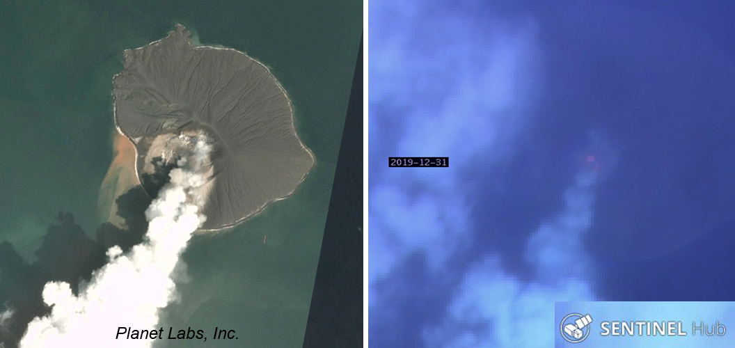 |
Figure 105. Satellite imagery of the explosions at Anak Krakatau on 30 and 31 December 2019 showed dense steam rising from the crater (left) and a thermal anomaly visible through moderate cloud cover (right). Left image courtesy of Simon Carn, and copyright by Planet Labs, Inc. Right image uses Atmospheric Penetration rendering (bands 12, 11, and 8a) to show the thermal anomaly at the base of the steam plume, courtesy of Sentinel Hub Playground. |
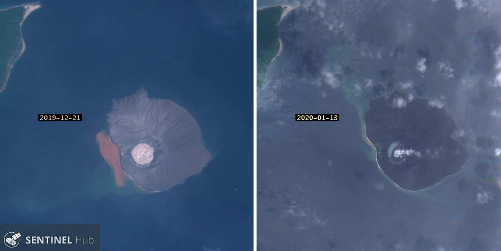 |
Figure 106. Sentinel-2 images of Anak Krakatau before (left, 21 December 2019) and after (right, 13 January 2020) explosions on 30 and 31 December 2019 show the filling in of the crater lake with new volcanic material. Natural color rendering based on bands 4,3, and 2. Courtesy of Sentinel Hub Playground. |
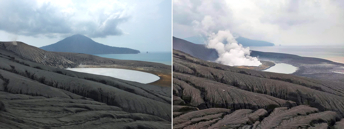 |
Figure 107. The crater lake at Anak Krakatau changed significantly between the first week of December 2019 (left) and 8 January 2020 (right) after explosions on 30 and 31 December 2019. Compare with figure 101, taken from the same location in mid-November 2019. Left image courtesy of Piotr Smieszek. Right image courtesy of Peter Rendezvous. |
Steam plumes rose 50-200 m above the crater during the first week of January 2020. An explosion on 7 January produced dense gray ash that rose 200 m from the crater and drifted E. Steam plume heights varied during the second week, with some plumes reaching 300 m above the crater. Multiple explosions on 15 January produced dense, gray and black ejecta that rose 150 m. Fog obscured the crater for most of the second half of the month; for a brief period, diffuse steam plumes were observed 25-1,000 m above the crater.
General Reference: Perttu A, Caudron C, Assink J D, Metz D, Tailpied D, Perttu B, Hibert C, Nurfiani D, Pilger C, Muzli M, Fee D, Andersen O L, Taisne B, 2020, Reconstruction of the 2018 tsunamigenic flank collapse and eruptive activity at Anak Krakatau based on eyewitness reports, seismo-acoustic and satellite observations, Earth and Planetary Science Letters, 541:116268. https://doi.org/10.1016/j.epsl.2020.116268.
Geological Summary. The renowned Krakatau (frequently mis-named as Krakatoa) volcano lies in the Sunda Strait between Java and Sumatra. Collapse of an older edifice, perhaps in 416 or 535 CE, formed a 7-km-wide caldera. Remnants of that volcano are preserved in Verlaten and Lang Islands; subsequently the Rakata, Danan, and Perbuwatan cones were formed, coalescing to create the pre-1883 Krakatau Island. Caldera collapse during the catastrophic 1883 eruption destroyed Danan and Perbuwatan, and left only a remnant of Rakata. This eruption caused more than 36,000 fatalities, most as a result of tsunamis that swept the adjacent coastlines of Sumatra and Java. Pyroclastic surges traveled 40 km across the Sunda Strait and reached the Sumatra coast. After a quiescence of less than a half century, the post-collapse cone of Anak Krakatau (Child of Krakatau) was constructed within the 1883 caldera at a point between the former Danan and Perbuwatan cones. Anak Krakatau has been the site of frequent eruptions since 1927.
Information Contacts: Pusat Vulkanologi dan Mitigasi Bencana Geologi (PVMBG, also known as Indonesian Center for Volcanology and Geological Hazard Mitigation, CVGHM), Jalan Diponegoro 57, Bandung 40122, Indonesia (URL: http://www.vsi.esdm.go.id/); MAGMA Indonesia, Kementerian Energi dan Sumber Daya Mineral (URL: https://magma.esdm.go.id/); MIROVA (Middle InfraRed Observation of Volcanic Activity), a collaborative project between the Universities of Turin and Florence (Italy) supported by the Centre for Volcanic Risk of the Italian Civil Protection Department (URL: http://www.mirovaweb.it/); Sentinel Hub Playground (URL: https://www.sentinel-hub.com/explore/sentinel-playground); Planet Labs, Inc. (URL: https://www.planet.com/); Amber Madden-Nadeau, Oxford University (URL: https://www.earth.ox.ac.uk/people/amber-madden-nadeau/, https://twitter.com/AMaddenNadeau/status/1159458288406151169); Anna Perttu, Earth Observatory of Singapore (URL: https://earthobservatory.sg/people/anna-perttu); Simon Carn, Michigan Tech University (URL: https://www.mtu.edu/geo/department/faculty/carn/; https://twitter.com/simoncarn/status/1211793124089044994); VolcanoYT, Indonesia (URL: https://volcanoyt.com/, https://twitter.com/VolcanoYTz/status/1182882409445904386/photo/1; Christoph Sator (URL: https://twitter.com/ChristophSator/status/1184713192670281728/photo/1); Tom Pfeiffer, Volcano Discovery (URL: http://www.volcanodiscovery.com/); Pascal Blondé, France (URL: https://pascal-blonde.info/portefolio-krakatau/, https://twitter.com/rajo_ameh/status/1199219837265960960); Alex Bogár, Budapest (URL: https://twitter.com/AlexEtna/status/1211396913699991557); Piotr (Piter) Smieszek, Yogyakarta, Java, Indonesia (URL: http://www.lombok.pl/, https://twitter.com/piotr_smieszek/status/1204545970962231296); Peter Rendezvous (URL: https://www.facebook.com/peter.rendezvous ); Wulkany swiata, Poland (URL: http://wulkanyswiata.blogspot.com/, https://twitter.com/Wulkany1/status/1214841708862693376).