Report on Unnamed (Tonga) — March 2020

Bulletin of the Global Volcanism Network, vol. 45, no. 3 (March 2020)
Managing Editor: Edward Venzke.
Edited by Kadie L. Bennis.
Unnamed (Tonga) Additional details and pumice raft drift maps from the August 2019 submarine eruption
Please cite this report as:
Global Volcanism Program, 2020. Report on Unnamed (Tonga) (Bennis, K.L., and Venzke, E., eds.). Bulletin of the Global Volcanism Network, 45:3. Smithsonian Institution. https://doi.org/10.5479/si.GVP.BGVN202003-243091
Unnamed
Tonga
18.325°S, 174.365°W; summit elev. -40 m
All times are local (unless otherwise noted)
In the northern Tonga region, approximately 80 km NW of Vava’u, large areas of floating pumice, termed rafts, were observed starting as early as 7 August 2019. The area of these andesitic pumice rafts was initially 195 km2 with the layers measuring 15-30 cm thick and were produced 200 m below sea level (Jutzeler et al. 2020). The previous report (BGVN 44:11) described the morphology of the clasts and the rafts, and their general westward path from 9 August to 9 October 2019, with the first sighting occurring on 9 August NW of Vava’u in Tonga. This report updates details regarding the submarine pumice raft eruption in early August 2019 using new observations and data from Brandl et al. (2019) and Jutzeler et al. (2020).
The NoToVE-2004 (Northern Tonga Vents Expedition) research cruise on the RV Southern Surveyor (SS11/2004) from the Australian CSIRO Marine National Facility traveled to the northern Tonga Arc and discovered several submarine basalt-to-rhyolite volcanic centers (Arculus, 2004). One of these volcanic centers 50 km NW of Vava’u was the unnamed seamount (volcano number 243091) that had erupted in 2001 and again in 2019, unofficially designated “Volcano F” for reference purposes by Arculus (2004) and also used by Brandl et al. (2019). It is a volcanic complex that rises more than 1 km from the seafloor with a central 6 x 8.7 km caldera and a volcanic apron measuring over 50 km in diameter (figures 19 and 20). Arculus (2004) described some of the dredged material as “fresh, black, plagioclase-bearing lava with well-formed, glassy crusts up to 2cm thick” from cones by the eastern wall of the caldera; a number of apparent flows, lava or debris, were observed draping over the northern wall of the caldera.
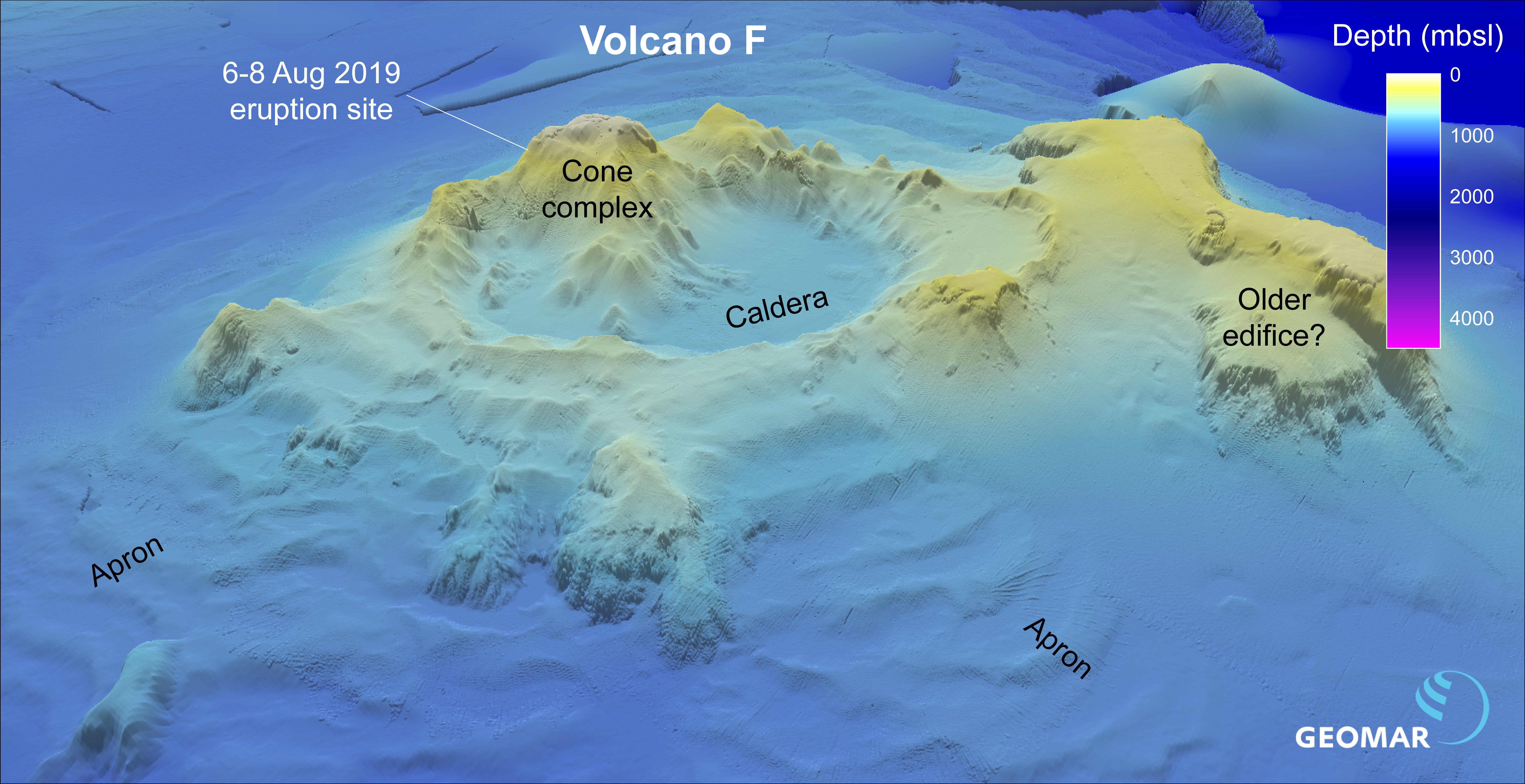 |
Figure 19. Visualization of the unnamed submarine Tongan volcano (marked “Volcano F”) using bathymetric data to show the site of the 6-8 August 2020 eruption and the rest of the cone complex. Courtesy of Philipp Brandl via GEOMAR. |
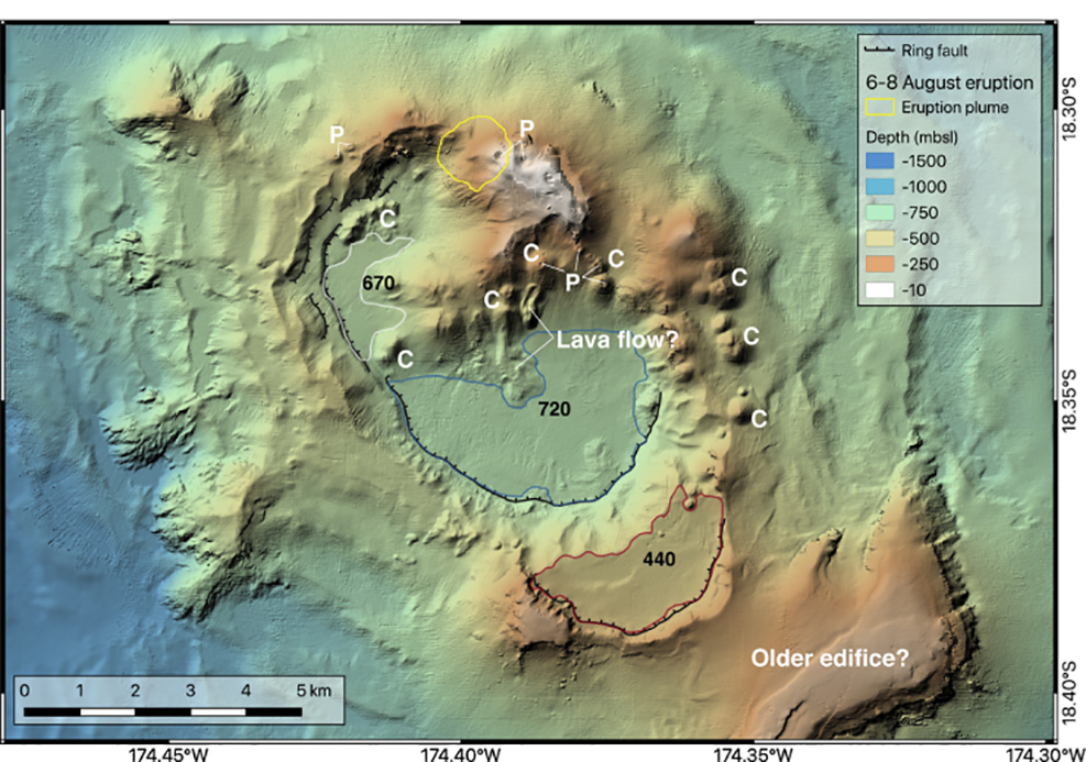 |
Figure 20. Map of the unnamed submarine Tongan volcano using satellite imagery, bathymetric data, with shading from the NW. The yellow circle indicates the location of the August 2019 activity. Young volcanic cones are marked “C” and those with pit craters at the top are marked with “P.” Courtesy of Brandl et al. (2019). |
The International Seismological Centre (ISC) Preliminary Bulletin listed a particularly strong (5.7 Mw) earthquake at 2201 local time on 5 August, 15 km SSW of the volcano at a depth of 10 km (Brandl et al. 2019). This event was followed by six slightly lower magnitude earthquakes over the next two days.
Sentinel-2 satellite imagery showed two concentric rings originating from a point source (18.307°S 174.395°W) on 6 August (figure 21), which could be interpreted as small weak submarine plumes or possibly a series of small volcanic cones, according to Brandl et al. (2019). The larger ring is about 1.2 km in diameter and the smaller one measures 250 m. By 8 August volcanic activity had decreased, but the pumice rafts that were produced remained visible through at least early October (BGVN 44:11). Brandl et al. (2019) states that, due to the lack of continued observed activity rising from this location, the eruption was likely a 2-day-long event during 6-8 August.
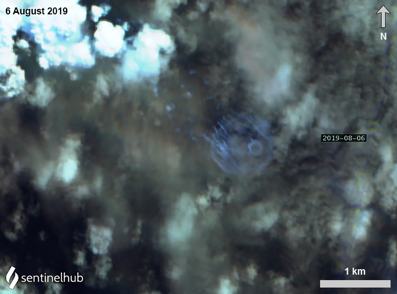 |
Figure 21. Sentinel-2 satellite image of possible gas/vapor emissions (streaks) on 6 August 2019 drifting NW, which is the interpreted site for the unnamed Tongan seamount. The larger ring is about 1.2 km in diameter and the smaller one measures 250 m. Image using False Color (urban) rendering (bands 12, 11, 4); courtesy of Sentinel Hub Playground. |
The pumice was first observed on 9 August occurred up to 56 km from the point of origin, according to Jutzeler et al. (2020). By calculating the velocity (14 km/day) of the raft using three satellites, Jutzeler et al. (2020) determined the pumice was erupted immediately after the satellite image of the submarine plumes on 6 August (UTC time). Minor activity at the vent may have continued on 8 and 11 August (UTC time) with pale blue-green water discoloration (figure 22) and a small (less than 1 km2) diffuse pumice raft 2-5 km from the vent.
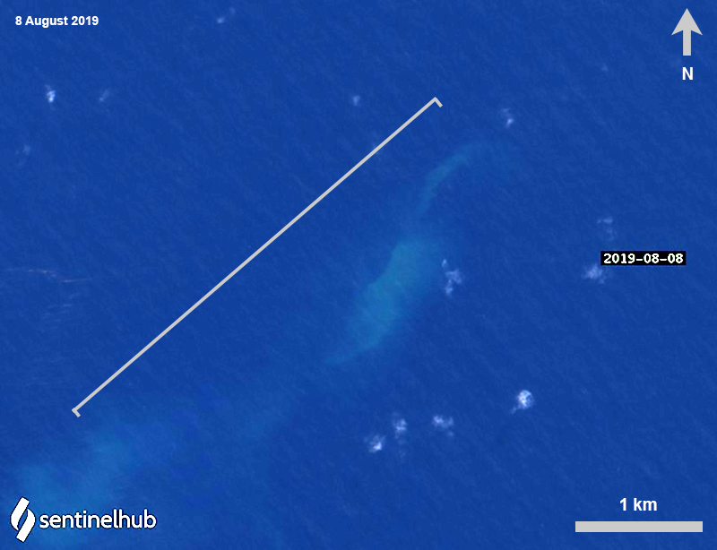 |
Figure 22. Sentinel-2 satellite image of the last visible activity occurring W of the unnamed submarine Tongan volcano on 8 August 2019, represented by slightly discolored blue-green water. Image using Natural Color rendering (bands 4, 3, 2) and enhanced with color correction; courtesy of Sentinel Hub Playground. |
Continuous observations using various satellite data and observations aboard the catamaran ROAM tracked the movement and extent of the pumice raft that was produced during the submarine eruption in early August (figure 23). The first visible pumice raft was observed on 8 August 2019, covering more than 136.7 km2 between the volcanic islands of Fonualei and Late and drifting W for 60 km until 9 August (Brandl et al. 2019; Jutzeler 2020). The next day, the raft increased to 167.2-195 km2 while drifting SW for 74 km until 14 August. Over the next three days (10-12 August) the size of the raft briefly decreased in size to less than 100 km2 before increasing again to 157.4 km2 on 14 August; at least nine individual rafts were mapped and identified on satellite imagery (Brandl et al. 2019). On 15 August sailing vessels observed a large pumice raft about 75 km W of Late Island (see details in BGVN 44:11), which was the same one as seen in satellite imagery on 8 August.
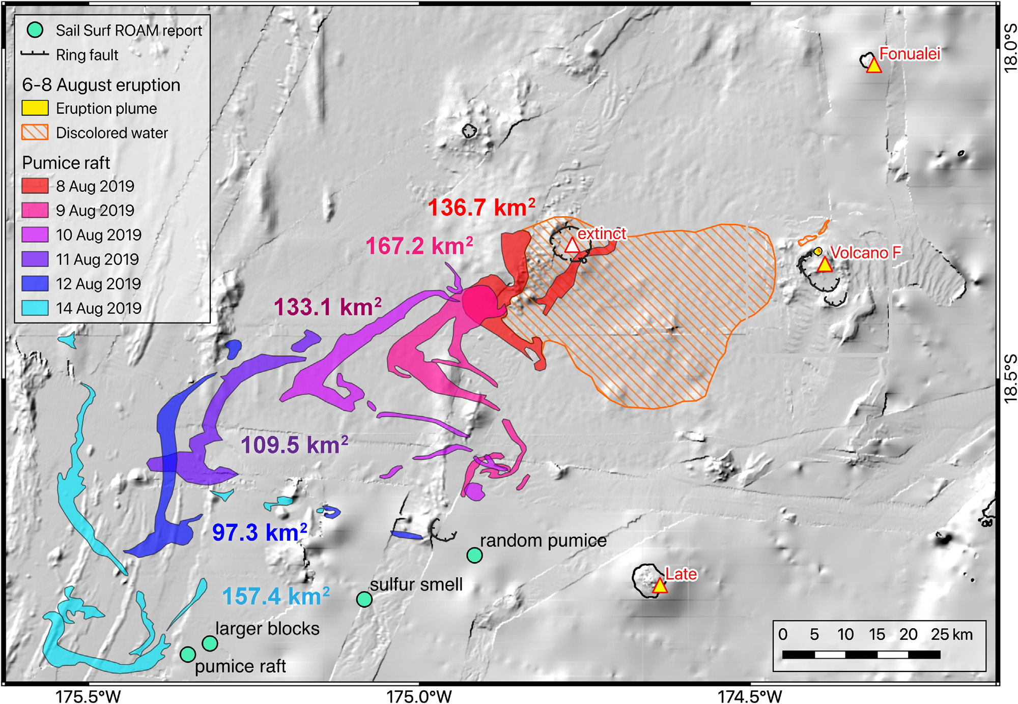 |
Figure 23. Map of the extent of discolored water and the pumice raft from the unnamed submarine Tongan volcano between 8 and 14 August 2019 using imagery from NASA’s MODIS, ESA’s Sentinel-2 satellite, and observations from aboard the catamaran ROAM (BGVN 44:11). Back-tracing the path of the pumice raft points to a source location at the unnamed submarine Tongan volcano. Courtesy of Brandl et al. (2019). |
By 17 August high-resolution satellite images showed an area of large and small rafts measuring 222 km2 and were found within a field of smaller rafts for a total extent of 1,350 km2, which drifted 73 km NNW through 22 August before moving counterclockwise for three days (figure f; Jutzeler et al., 2020). Small pumice ribbons encountered the Oneata Lagoon on 30 August, the first island that the raft came into contact (Jutzeler et al. 2020). By 2 September, the main raft intersected with Lakeba Island (460 km from the source) (figure 24), breaking into smaller ribbons that started to drift W on 8 September. On 19 September the small rafts (less than 100 m x less than 2 km) entered the strait between Viti Levu and Vanua Levu, the two main islands of Fiji, while most of the others were stranded 60 km W in the Yasawa Islands for more than two months (Jutzeler et al., 2020).
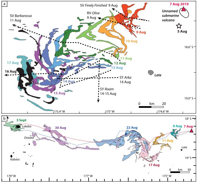 |
Figure 24. Time-series map of the raft dispersal from the unnamed submarine Tongan volcano using multiple satellite images. A) Map showing the first days of the raft dispersal starting on 7 August 2019 and drifting SW from the vent (marked with a red triangle). Precursory seismicity that began on 5 August is marked with a white star. By 15-17 August the raft was entrained in an ocean loop or eddy. The dashed lines represent the path of the sailing vessels. B) Map of the raft dispersal using high-resolution Sentinel-2 and -3 imagery. Two dispersal trails (red and blue dashed lines) show the daily dispersal of two parts of the raft that were separated on 17 August 2019. Courtesy of Jutzeler et al. (2020). |
References: Arculus R J, SS2004/11 shipboard scientists, 2004. SS11/2004 Voyage Summary: NoToVE-2004 (Northern Tonga Vents Expedition): submarine hydrothermal plume activity and petrology of the northern Tofua Arc, Tonga. https://www.cmar.csiro.au/data/trawler/survey_details.cfm?survey=SS200411
Brandl P A, Schmid F, Augustin N, Grevemeyer I, Arculus R J, Devey C W, Petersen S, Stewart M , Kopp K, Hannington M D, 2019. The 6-8 Aug 2019 eruption of ‘Volcano F’ in the Tofua Arc, Tonga. Journal of Volcanology and Geothermal Research: https://doi.org/10.1016/j.jvolgeores.2019.106695
Jutzeler M, Marsh R, van Sebille E, Mittal T, Carey R, Fauria K, Manga M, McPhie J, 2020. Ongoing Dispersal of the 7 August 2019 Pumice Raft From the Tonga Arc in the Southwestern Pacific Ocean. AGU Geophysical Research Letters: https://doi.orh/10.1029/2019GL086768.
Geological Summary. A submarine volcano along the Tofua volcanic arc ~45 km NW of Vava'u Island was first observed in September 2001, ~35 km S of Fonualei and 60 km NE of Late volcano. The site of the eruption is at an approximate bathymetric depth of 300 m. T-phase waves were recorded on 27-28 September 2001, and on the 27th local fishermen observed an ash-rich eruption column that rose above the ocean surface. No eruptive activity was reported after the 28th, but water discoloration was documented the following month. In early November rafts and strandings of dacitic pumice were reported along the coasts of Kadavu and Viti Levu in Fiji. The depth of the summit of the submarine cone following the eruption was determined to be 40 m during a 2007 survey; the crater of the 2001 eruption was open to the E.
Information Contacts: Jan Steffen, Communication and Media, GEOMAR Helmholtz Centre for Ocean Research, Kiel, Germany; Sentinel Hub Playground (URL: https://www.sentinel-hub.com/explore/sentinel-playground).