Report on Tinakula (Solomon Islands) — July 2020
Bulletin of the Global Volcanism Network, vol. 45, no. 7 (July 2020)
Managing Editor: Edward Venzke.
Edited by Kadie L. Bennis.
Tinakula (Solomon Islands) Intermittent small thermal anomalies and gas-and-steam plumes during January-June 2020
Please cite this report as:
Global Volcanism Program, 2020. Report on Tinakula (Solomon Islands) (Bennis, K.L., and Venzke, E., eds.). Bulletin of the Global Volcanism Network, 45:7. Smithsonian Institution. https://doi.org/10.5479/si.GVP.BGVN202007-256010
Tinakula
Solomon Islands
10.386°S, 165.804°E; summit elev. 796 m
All times are local (unless otherwise noted)
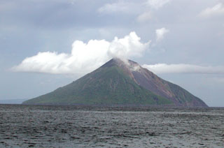
Tinakula is a remote stratovolcano located 100 km NE of the Solomon Trench at the N end of the Santa Cruz. In 1971, an eruption with lava flows and ash explosions caused the small population to evacuate the island. Volcanism has previously been characterized by an ash explosion in October 2017 and the most recent eruptive period that began in December 2018 with renewed thermal activity. Activity since then has consisted of intermittent thermal activity and dense gas-and-steam plumes (BGVN 45:01), which continues into the current reporting period. This report updates information from January-June 2020 using primary source information from various satellite data, as ground observations are rarely available.
MIROVA (Middle InfraRed Observation of Volcanic Activity) analysis of MODIS satellite data showed weak, intermittent, but ongoing thermal activity during January-June 2020 (figure 41). A small cluster of slightly stronger thermal signatures was detected in late February to early March, which is correlated to MODVOLC thermal alert data; four thermal hotspots were recorded on 20, 27, and 29 February and 1 March. However, observations using Sentinel-2 satellite imagery were often obscured by clouds. In addition to the weak thermal signatures, dense gas-and-steam plumes were observed in Sentinel-2 satellite imagery rising from the summit during this reporting period (figure 42).
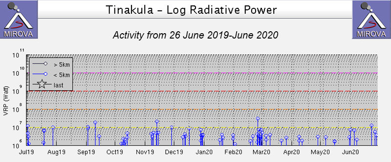 |
Figure 41. Weak thermal anomalies at Tinakula from 26 June 2019 through June 2020 as recorded by the MIROVA system (Log Radiative Power) were intermittent and clustered more strongly in late February to early March. Courtesy of MIROVA. |
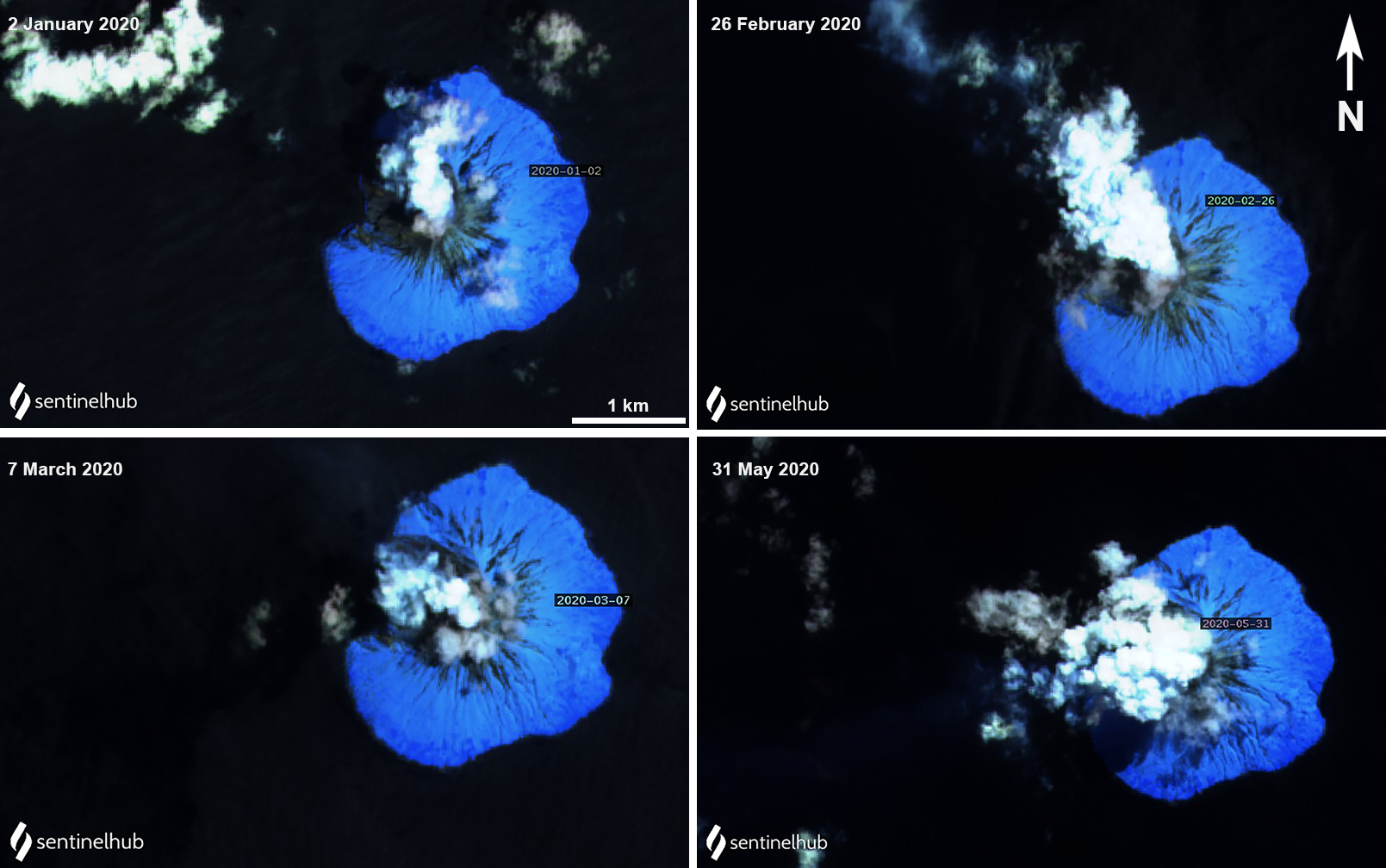 |
Figure 42. Sentinel-2 satellite imagery shows ongoing gas-and-steam plumes rising from Tinakula during January through May 2020. Images with atmospheric penetration (bands 12, 11, 8a) rendering; courtesy of Sentinel Hub Playground. |
Three distinct thermal anomalies were observed in Sentinel-2 thermal satellite imagery on 22 January, 11 April, and 6 May 2020, accompanied by some gas-and-steam emissions (figure 43). The hotspot on 22 January was slightly weaker than the other two days, and was seen on the W flank, compared to the other two that were observed in the summit crater. According to MODVOLC thermal alerts, a hotspot was recorded on 6 May, which corresponded to a Sentinel-2 thermal satellite image with a notable anomaly in the summit crater (figure 43). On 10 June no thermal anomaly was seen in Sentinel-2 satellite imagery due to the presence of clouds; however, what appeared to be a dense gas-and-steam plume was extending W from the summit.
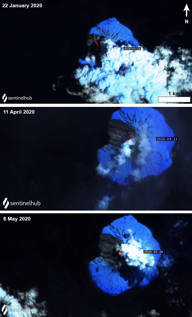 |
Figure 43. Sentinel-2 thermal satellite images showing a weak thermal activity (bright yellow-orange) on 22 January 2020 on the W flank of Tinakula (top) and slightly stronger thermal hotspots on 11 April (middle) and 6 May (bottom) in at the summit, which are accompanied by gas-and-steam emissions. Images with atmospheric penetration (bands 12, 11, 8a) rendering; courtesy of Sentinel Hub Playground. |
Geological Summary. The small 3.5-km-wide island of Tinakula is the exposed summit of a massive stratovolcano at the NW end of the Santa Cruz islands. It has a breached summit crater that extends from the summit to below sea level. Landslides enlarged this scarp in 1965, creating an embayment on the NW coast. The Mendana cone is located on the SE side. The dominantly andesitic volcano has frequently been observed in eruption since the era of Spanish exploration began in 1595. In about 1840, an explosive eruption apparently produced pyroclastic flows that swept all sides of the island, killing its inhabitants. Recorded eruptions have frequently originated from a cone constructed within the large breached crater. These have left the upper flanks and the steep apron of lava flows and volcaniclastic debris within the breach unvegetated.
Information Contacts: MIROVA (Middle InfraRed Observation of Volcanic Activity), a collaborative project between the Universities of Turin and Florence (Italy) supported by the Centre for Volcanic Risk of the Italian Civil Protection Department (URL: http://www.mirovaweb.it/); Hawai'i Institute of Geophysics and Planetology (HIGP) - MODVOLC Thermal Alerts System, School of Ocean and Earth Science and Technology (SOEST), Univ. of Hawai'i, 2525 Correa Road, Honolulu, HI 96822, USA (URL: http://modis.higp.hawaii.edu/); Sentinel Hub Playground (URL: https://www.sentinel-hub.com/explore/sentinel-playground).