Report on Tofua (Tonga) — August 2020
Bulletin of the Global Volcanism Network, vol. 45, no. 8 (August 2020)
Managing Editor: Edward Venzke.
Edited by Kadie L. Bennis.
Tofua (Tonga) Intermittent thermal anomalies in the Lofia crater from October 2015 through July 2020
Please cite this report as:
Global Volcanism Program, 2020. Report on Tofua (Tonga) (Bennis, K.L., and Venzke, E., eds.). Bulletin of the Global Volcanism Network, 45:8. Smithsonian Institution. https://doi.org/10.5479/si.GVP.BGVN202008-243060
Tofua
Tonga
19.75°S, 175.07°W; summit elev. 515 m
All times are local (unless otherwise noted)
Tofua is a remote volcano located in the central part of the Tonga Islands group. The summit contains a 5-km-wide caldera; three post-caldera cones were constructed at the N end of a caldera lake. The easternmost cone has three craters that have produced young basaltic-andesite lava flows, some of which traveled into the caldera lake. The largest and northernmost of the cones, Lofia, has a steep-sided crater that is 70 m wide and 120 m deep and has been the source of historical eruptions, first reported in the 18th century. The previous report described few thermal alerts primarily during the latter part of 2014 using satellite data (BGVN 40:04), after which no thermal anomalies were detected between 18 October 2014 and 1 October 2015. A new eruptive period began on 2 October 2015 when a thermal anomaly was detected on the N end of the caldera. A posting of satellite imagery by Cultur Volcan about this ongoing activity resulted in this report; it updates activity from July 2015-July 2020 and includes information from various satellite data, primarily looking at thermal anomalies.
Summary of activity during October 2015-July 2020. No ash advisories from the Wellington Volcanic Ash Advisory Centre were issued during the reporting period. There was no activity detected in available satellite data from 18 October 2014 to 1 October 2015; however, on 2 October 2015 the MODVOLC system registered a single MODIS thermal anomaly in the N end of the caldera, marking the beginning of a new eruptive period. Intermittent hotspots were detected by Sentinel-2 thermal satellite imagery, Suomi NPP/VIIRS sensor data, and the MODVOLC system throughout the reporting period, with more frequent anomalies observed beginning in February 2018 through July 2020 (figure 8).
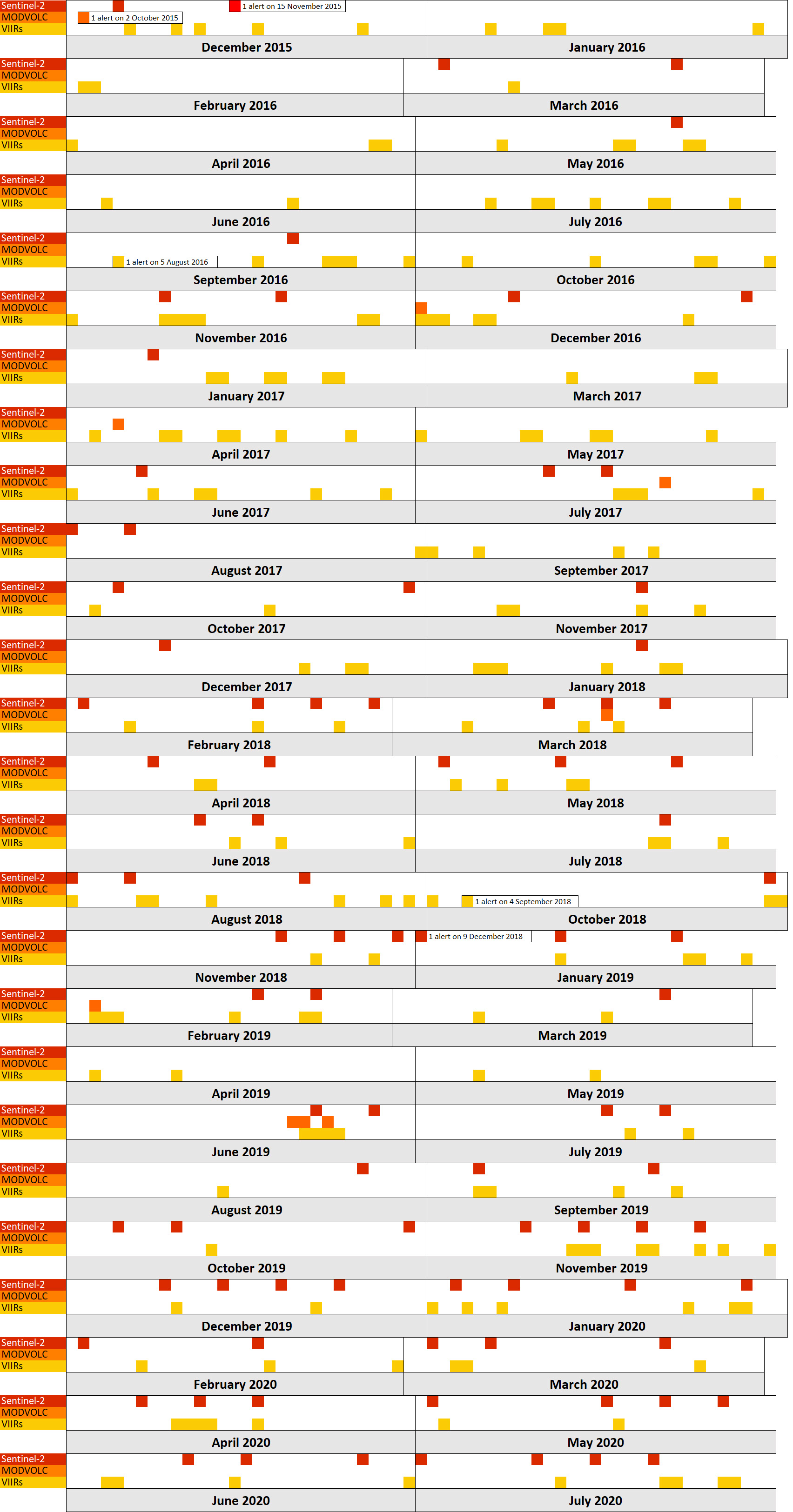 |
Figure 8. Timeline summary of observed activity at Tofua from October 2015 through July 2020. For Sentinel-2, MODVOLC, and VIIRS data, the dates indicated represent detected thermal anomalies. White areas indicate no activity was observed, which may also be due to cloud cover. Each cell represents one calendar day. Data courtesy of Sentinel Hub Playground, HIGP, and NASA Worldview using the “Fire and Thermal Anomalies” layer. |
Sentinel-2 thermal satellite imagery and NASA Worldview captured intermittent variable-strength thermal anomalies during November 2015 through July 2020, primarily in the Lofia crater on the N end of the caldera lake (figures 9 and 10). Activity was relatively lower from November 2015 through 2017 compared to that of 2018 through July 2020. Some anomalies may have been obscured by cloud coverage. A significant thermal anomaly was observed during 22 June 2019, located in the N end of the caldera. Planet Labs satellite imagery shows gas-and-steam emissions rising from the Lofia crater and drifting NW during March and May 2020 (figure 11).
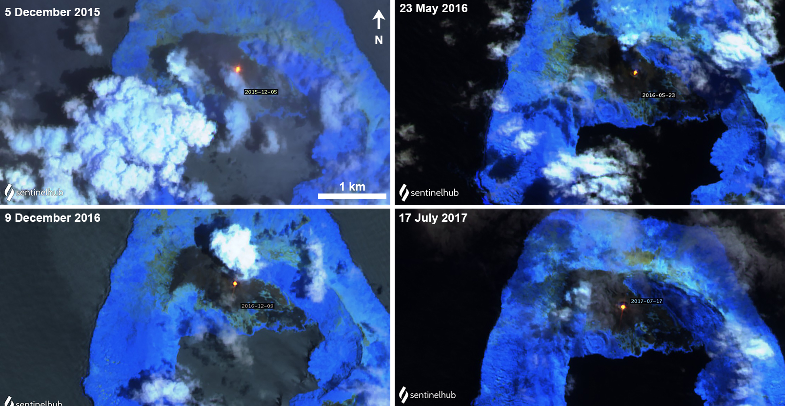 |
Figure 9. Sentinel-2 thermal satellite imagery detected thermal anomalies (bright yellow-orange) at Tofua occurred primarily in the Lofia crater on the N end of the caldera lake during 2015-2017. Sentinel-2 atmospheric penetration (bands 12, 11, 8A) images courtesy of Sentinel Hub Playground. |
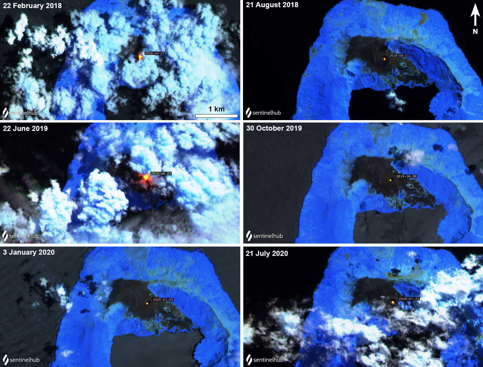 |
Figure 10. A consistent thermal anomaly (bright yellow-orange) was detected in Sentinel-2 thermal satellite imagery at Tofua continued primarily in the Lofia crater on the N end of the caldera lake during 2018-2020. Sentinel-2 atmospheric penetration (bands 12, 11, 8A) images courtesy of Sentinel Hub Playground. |
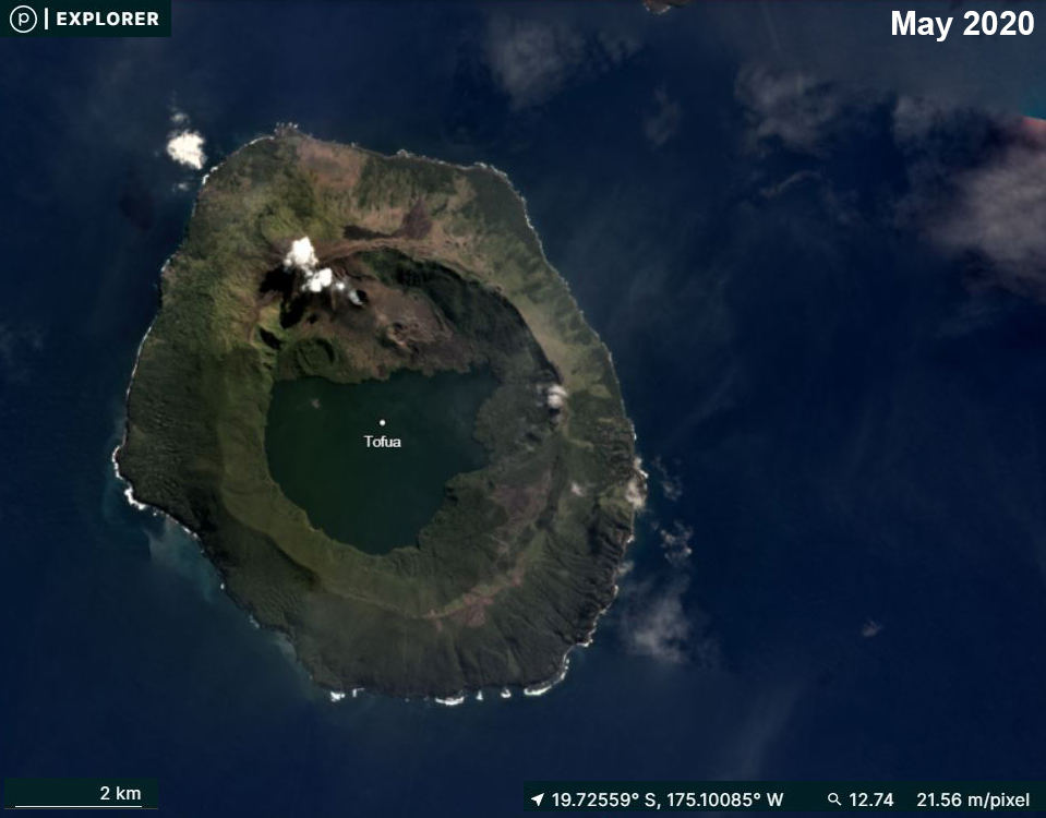 |
Figure 11. Planet Labs imagery showing a small gas-and-steam plume rising from Tofua during May 2020 drifting NW. Courtesy of Planet Labs. |
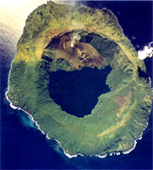
Geological Summary. The low, forested Tofua Island in the central part of the Tonga Islands group is the emergent summit of a large stratovolcano that was seen in eruption by Captain Cook in 1774. The summit contains a 5-km-wide caldera whose walls drop steeply about 500 m. Three post-caldera cones were constructed at the northern end of a cold fresh-water caldera lake, whose surface lies only 30 m above sea level. The easternmost cone has three craters and produced young basaltic andesite lava flows, some of which traveled into the caldera lake. The largest and northernmost of the cones, Lofia, has a steep-sided crater that is 70 m wide and 120 m deep and has been the source of historical eruptions, first reported in the 18th century. The fumarolically active crater of Lofia has a flat floor formed by a ponded lava flow.
Information Contacts: Hawai'i Institute of Geophysics and Planetology (HIGP) - MODVOLC Thermal Alerts System, School of Ocean and Earth Science and Technology (SOEST), Univ. of Hawai'i, 2525 Correa Road, Honolulu, HI 96822, USA (URL: http://modis.higp.hawaii.edu/); Sentinel Hub Playground (URL: https://www.sentinel-hub.com/explore/sentinel-playground); NASA Worldview (URL: https://worldview.earthdata.nasa.gov/); Planet Labs, Inc. (URL: https://www.planet.com/); Cultur Volcan, Journal d’un volcanophile, (URL: https://laculturevolcan.blogspot.com).