Report on Barren Island (India) — August 2020

Bulletin of the Global Volcanism Network, vol. 45, no. 8 (August 2020)
Managing Editor: Edward Venzke.
Edited by Kadie L. Bennis.
Barren Island (India) Intermittent weak thermal anomalies during February-July 2020
Please cite this report as:
Global Volcanism Program, 2020. Report on Barren Island (India) (Bennis, K.L., and Venzke, E., eds.). Bulletin of the Global Volcanism Network, 45:8. Smithsonian Institution. https://doi.org/10.5479/si.GVP.BGVN202008-260010
Barren Island
India
12.278°N, 93.858°E; summit elev. 354 m
All times are local (unless otherwise noted)
Barren Island is a remote island east of India in the Andaman Islands. Its most recent eruptive period began in September 2018 with volcanism characterized by thermal anomalies and small ash plumes (BGVN 45:02). This report updates information from February through July 2020 using various satellite data as a primary source of information.
MIROVA (Middle InfraRed Observation of Volcanic Activity) analysis of MODIS satellite data showed intermittent low-power thermal anomalies within 5 km of the summit from early September 2019 through July 2020 (figure 44). The frequency of the thermal anomalies decreased during mid-May 2020 with only six detected between June and July 2020. Sentinel-2 thermal satellite imagery showed weak thermal hotspots in the summit crater on 5 and 10 February, and 5 April (figure 45). In comparison, Suomi NPP/VIIRS sensor data registered elevated temperatures during 13-14 May and 18 July. Intermittent gas-and-steam emissions were also observed in Sentinel-2 satellite imagery on days with little to no cloud coverage. A small ash plume was observed in Sentinel-2 satellite imagery drifting NW on 24 June; there was no thermal anomaly detected that day (figure 46).
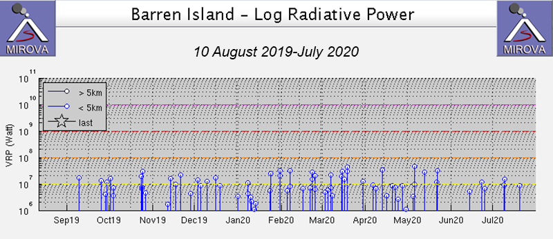 |
Figure 44. Intermittent thermal anomalies at Barren Island for 10 August 2019 through July 2020 were detected by the MIROVA graph (Log Radiative Power). The frequency of the anomalies decreased after mid-May. Courtesy of MIROVA. |
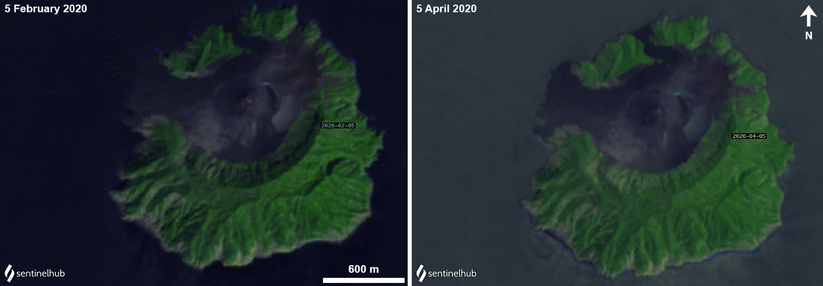 |
Figure 45. Sentinel-2 thermal images show weak thermal anomalies (bright yellow-orange) at Barren Island on 5 February (left) and 5 April (right) 2020. Images with False color (bands 12, 11, 4) rendering courtesy of Sentinel Hub Playground. |
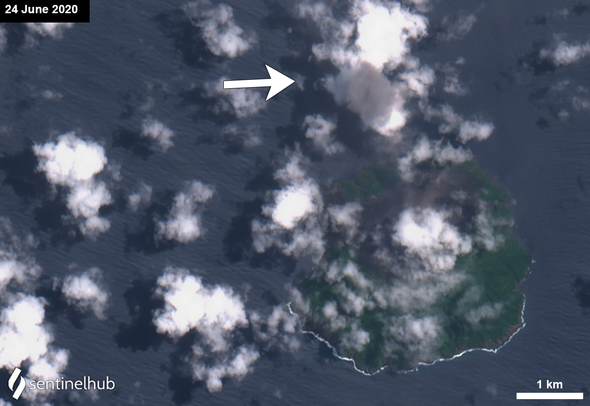 |
Figure 46. Sentinel-2 satellite image showing a small ash plume rising from Barren Island and drifting NW on 24 June 2020. Image with Natural color (bands 4, 3, 2) rendering courtesy of Sentinel Hub Playground. |
Geological Summary. Barren Island, a possession of India in the Andaman Sea about 135 km NE of Port Blair in the Andaman Islands, is the only historically active volcano along the N-S volcanic arc extending between Sumatra and Burma (Myanmar). It is the emergent summit of a volcano that rises from a depth of about 2250 m. The small, uninhabited 3-km-wide island contains a roughly 2-km-wide caldera with walls 250-350 m high. The caldera, which is open to the sea on the west, was created during a major explosive eruption in the late Pleistocene that produced pyroclastic-flow and -surge deposits. Historical eruptions have changed the morphology of the pyroclastic cone in the center of the caldera, and lava flows that fill much of the caldera floor have reached the sea along the western coast.
Information Contacts: MIROVA (Middle InfraRed Observation of Volcanic Activity), a collaborative project between the Universities of Turin and Florence (Italy) supported by the Centre for Volcanic Risk of the Italian Civil Protection Department (URL: http://www.mirovaweb.it/); Sentinel Hub Playground (URL: https://www.sentinel-hub.com/explore/sentinel-playground); NASA Worldview (URL: https://worldview.earthdata.nasa.gov/).