Report on Whakaari/White Island (New Zealand) — December 2020

Bulletin of the Global Volcanism Network, vol. 45, no. 12 (December 2020)
Managing Editor: Edward Venzke.
Edited by Kadie L. Bennis.
Whakaari/White Island (New Zealand) Gas-and-steam emissions with some re-suspended ash in November 2020
Please cite this report as:
Global Volcanism Program, 2020. Report on Whakaari/White Island (New Zealand) (Bennis, K.L., and Venzke, E., eds.). Bulletin of the Global Volcanism Network, 45:12. Smithsonian Institution. https://doi.org/10.5479/si.GVP.BGVN202012-241040
Whakaari/White Island
New Zealand
37.52°S, 177.18°E; summit elev. 294 m
All times are local (unless otherwise noted)
Whakaari/White Island, located in the Bay of Plenty 50 km offshore of North Island, has been New Zealand’s most active volcano since 1976. Activity has been previously characterized by phreatic activity, explosions, and ash emissions (BGVN 42:05). The most recent eruption occurred on 9 December 2019, which consisted of an explosion that generated an ash plume and pyroclastic surge that affected the entire crater area, resulting in 21 fatalities and many injuries (BGVN 45:02). This report updates information from February through November 2020, which includes dominantly gas-and-steam emissions along with elevated surface temperatures, using reports from the New Zealand GeoNet Project, the Wellington Volcanic Ash Advisory Centre (VAAC), and satellite data.
Activity at Whakaari/White Island has declined and has been dominated by white gas-and-steam emissions during the reporting period; no explosive eruptive activity has been detected since 9 December 2019. During February through 22 June, the Volcanic Activity Level (VAL) remained at a 2 (moderate to heightened volcanic unrest) and the Aviation Color Code was Yellow. GeoNet reported that satellite data showed some subsidence along the W wall of the Main Crater and near the 1914 landslide scarp, though the rate had reduced compared to previous months. Thermal infrared data indicated that the fumarolic gases and five lobes of lava that were first observed in early January 2020 in the Main Crater were 550-570°C on 4 February and 660°C on 19 February. A small pond of water had begun to form in the vent area and exhibited small-scale gas-and-steam-driven water jetting, similar to the activity during September-December 2019. Gas data showed a steady decline in SO2 and CO2 levels, though overall they were still slightly elevated.
Similar activity was reported in March and April; the temperatures of the fumaroles and lava in the Main Crater were 746°C on 10 March, the highest recorded temperature to date. SO2 and CO2 gas emissions remained elevated, though had overall decreased since December 2019. Small-scale water jetting continued to be observed in the vent area. During April, public reports mentioned heightened gas-and-steam activity, but no eruptions were detected. A GeoNet report issued on 16 April stated that high temperatures were apparent in the vent area at night.
Whakaari remained at an elevated state of unrest during May, consisting of dominantly gas-and-steam emissions. Monitoring flights noted that SO2 and CO2 emissions had increased briefly during 20-27 May. On 20 May, the lava lobes remained hot, with temperatures around 500°C; a nighttime glow from the gas emissions surrounding the lava was visible in webcam images. Tremor levels remained low with occasional slightly elevated episodes, which included some shallow-source volcanic earthquakes. Satellite-based measurements recorded several centimeters of subsidence in the ground around the active vent area since December 2019. During a gas observation flight on 28 May there was a short-lived gas pulse, accompanied by an increase in SO2 and CO2 emissions, and minor inflation in the vent area (figure 96).
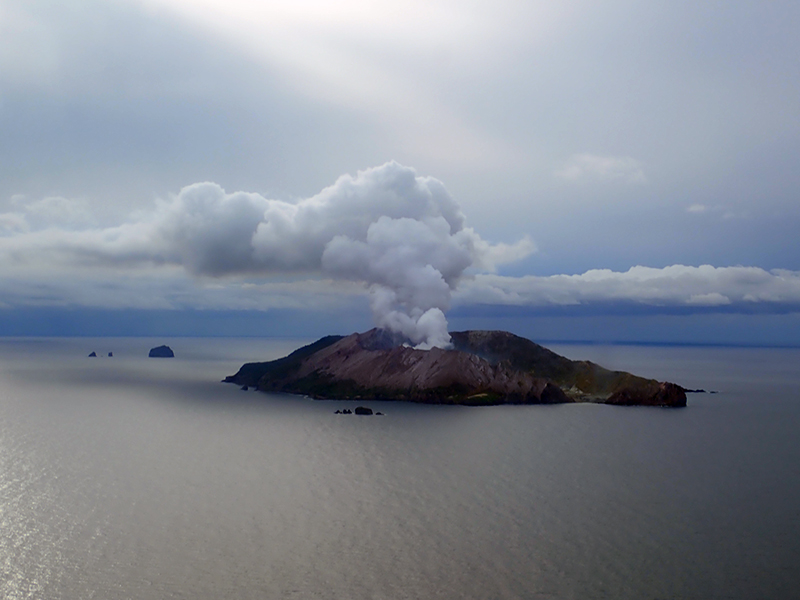 |
Figure 96. Photo of a strong gas-and-steam plume rising above Whakaari/White Island on 28 May 2020. Courtesy of GeoNet. |
An observation flight made on 3 June reported a decline in gas flux compared to the measurements made on 28 May. Thermal infrared images taken during the flight showed that the lava lobes were still hot, at 450°C, and continued to generate incandescence that was visible at night in webcams. On 16 June the VAL was lowered to 1 (minor volcanic unrest) and on 22 June the Aviation Color Code had decreased to Green.
Minor volcanic unrest continued in July; the level of volcanic tremors has remained generally low, with the exception of two short bursts of moderate volcanic tremors in at the beginning of the month. Temperatures in the active vents remained high (540°C) and volcanic gases persisted at moderate rate, similar to those measured since May, according to an observation flight made during the week of 30 July. Subsidence continued to be observed in the active vent area, as well as along the main crater wall, S and W of the active vents. Recent rainfall has created small ponds of water on the crater floor, though they did not infiltrate the vent areas.
Gas-and-steam emissions persisted during August through October at relatively high rates (figures 97 and 98). A short episode of moderate volcanic tremor was detected in early August, but otherwise seismicity remained low. Updated temperatures of the active vent area were 440°C on 15 September, which had decreased 100°C since July. Rain continued to collect at the crater floor, forming a small lake; minor areas of gas-and-steam emissions can be seen in this lake. Ongoing subsidence was observed on the Main Crater wall and S and W of the 2019 active vents.
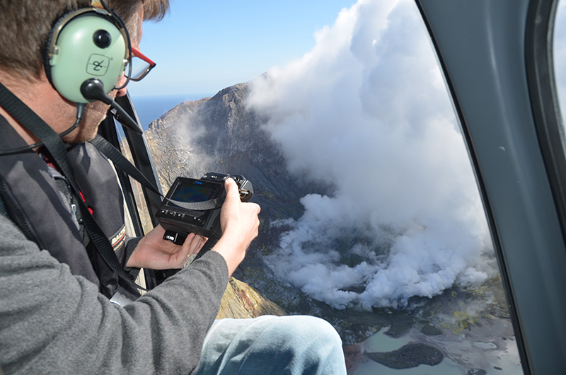 |
Figure 97. Photo of an observation flight over Whakaari/White Island on 8 September 2020 showing white gas-and-steam emissions from the vent area. Photo courtesy of Brad Scott, GeoNet. |
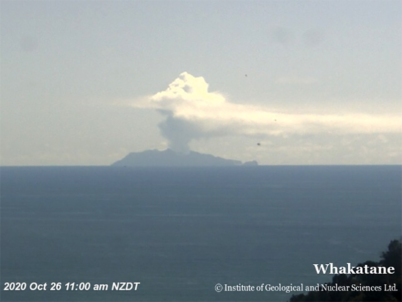 |
Figure 98. Image of Whakaari/White Island from Whakatane in the North Island of New Zealand showing a white gas-and-steam plume on 26 October 2020. Courtesy of GeoNet. |
Activity during November was primarily characterized by persistent, moderate-to-large gas-and-steam plumes that drifted downwind for several kilometers but did not reach the mainland. The SO2 flux was 618 tons/day and the CO2 flux was 2,390 tons/day. New observations on 11 November noted some occasional ash deposits on the webcams in conjunction with mainland reports of a darker than usual plume (figure 99). Satellite images provided by MetService, courtesy of the Japan Meteorological Agency, confirmed the ash emission, but later images showed little to no apparent ash; GNS confirmed that no eruptive activity had occurred. Initial analyses indicated that the ash originated from loose material around the vent was being entrained into the gas-and-steam plumes. Observations from an overflight on 12 November showed that there was no substantial change in the location and size of the active vents; rainfall continued to collect on the floor of the 1978/90 Crater, reforming the shallow lake. A small sequence of earthquakes was detected close to the volcano with several episodes of slightly increased volcanic tremors.
During 12-14 November the Wellington VAAC issued multiple advisories noting gas, steam, and ash plumes that rose to 1.5-1.8 km altitude and drifted E and SE, based on satellite data, reports from pilots, and reports from GeoNet. As a result, the VAL was increased to 2 and the Aviation Color Code was raised to Yellow. Scientists on another observation flight on 16 November reported that small amounts of ash continued to be present in gas-and-steam emissions, though laboratory analyses showed that this ash was resuspended material and not from new eruptive or magmatic activity. The SO2 and CO2 flux remained above background levels but were slightly lower than the previous week’s measurements: 710 tons/day and 1,937 tons/day. Seismicity was similar to the previous week, characterized by a sequence of small earthquakes, a larger than normal volcanic earthquake located near the volcano, and ongoing low-level volcanic tremors. During 16-17 November plumes with resuspended ash were observed rising to 460 m altitude, drifting E and NE, according to a VAAC advisory (figure 99). During 20-24 November gas-and-steam emissions that contained a minor amount of resuspended ash rose to 1.2 km altitude and drifted in multiple directions, based on webcam and satellite images and information from GeoNet.
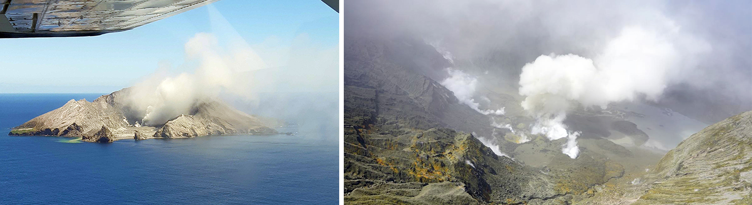 |
Figure 99. Left: Photo of a gas observation flight over Whakaari/White Island on 11 November 2020 showing some dark particles in the gas-and-steam plumes, which were deposited on some webcams. Photo has been color corrected and straightened. Courtesy of GeoNet. Right: Photo showing gas, steam, and ash emissions rising above the 2019 Main Crater area on 16 November 2020. Courtesy of GNS Science (17 November 2020 report). |
MIROVA (Middle InfraRed Observation of Volcanic Activity) analysis of MODIS satellite data shows a total of eleven low-power thermal anomalies during January to late March 2020; a single weak thermal anomaly was detected in early July (figure 100). The elevated surface temperatures during February-May 2020 were detected in Sentinel-2 thermal satellite images in the Main Crater area, occasionally accompanied by gas-and-steam emissions (figure 101). Persistent white gas-and-steam emissions rising above the Main Crater area were observed in satellite imagery on clear weather days and drifting in multiple directions (figure 102). The small lake that had formed due to rainfall was also visible to the E of the active vents.
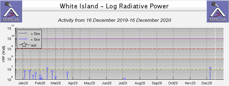 |
Figure 100. Low-power, infrequent thermal activity at Whakaari/White Island was detected during January through late March 2020, as reflected in the MIROVA data (Log Radiative Power). A single thermal anomaly was shown in early July. Courtesy of MIROVA. |
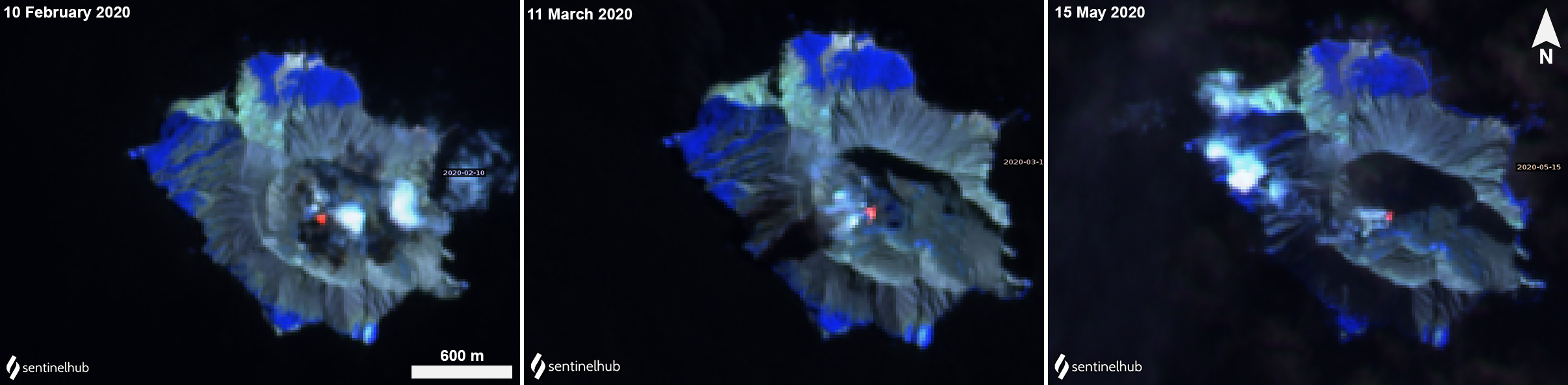 |
Figure 101. Sentinel-2 thermal satellite images in the Main Crater area of Whakaari/White Island show residual elevated temperatures from the December 2019 eruption, accompanied by gas-and-steam emissions and drifting in different directions during February-May 2020. Images using “Atmospheric penetration” rendering (bands 12, 11, 8a). Courtesy of Sentinel Hub Playground. |
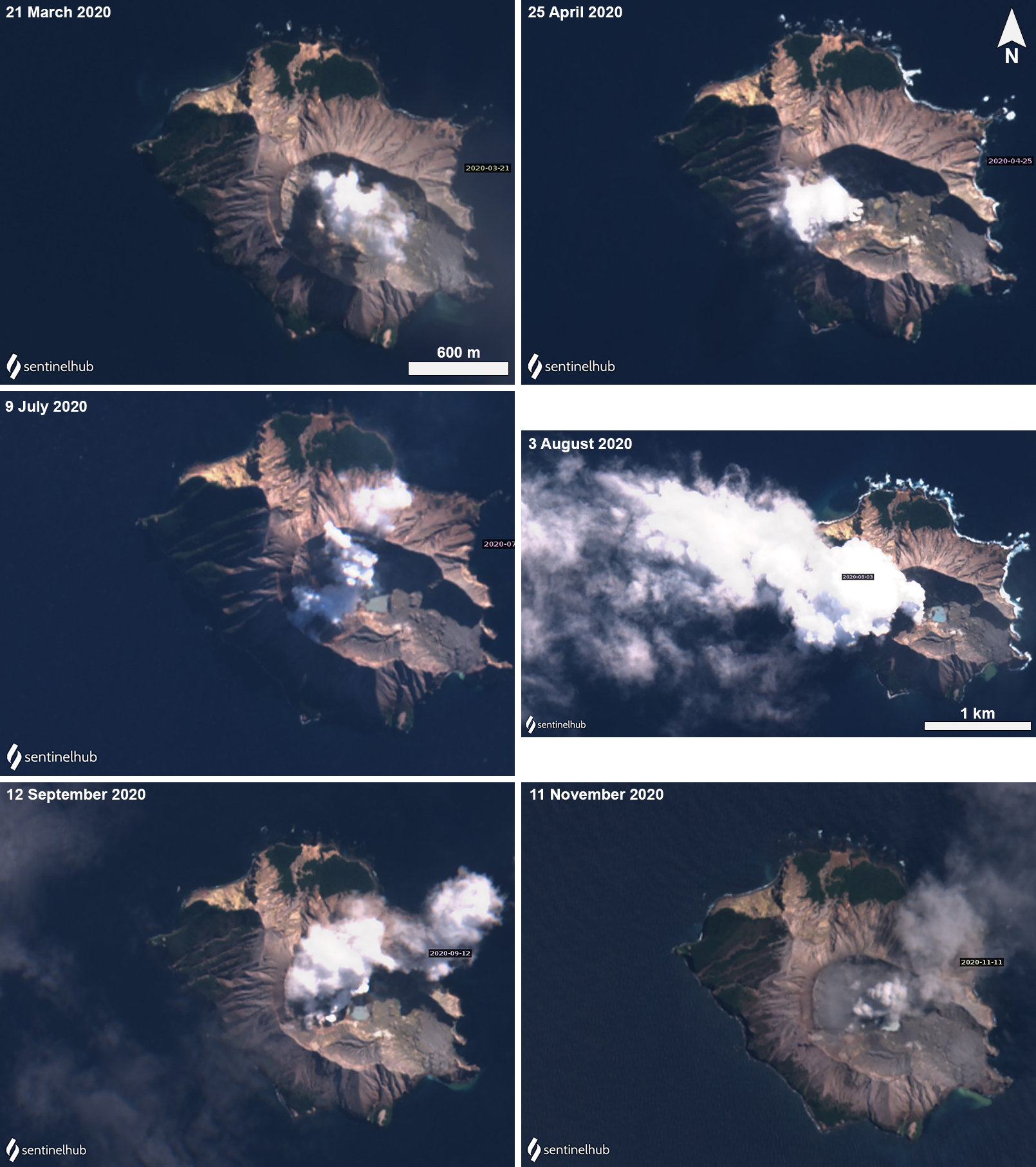 |
Figure 102. Sentinel-2 images showing persistent white gas-and-steam plumes rising from Main Crater area of Whakaari/White Island during March-November 2020 and drifting in multiple directions. A small pond of water (light blue-green) is visible in the vent area to the E of the plumes. On 11 November (bottom right), the color of the plume is gray and contains a small amount of ash. Images using “Natural color” rendering (bands 4, 3, 2). Courtesy of Sentinel Hub Playground. |
Geological Summary. The uninhabited Whakaari/White Island is the 2 x 2.4 km emergent summit of a 16 x 18 km submarine volcano in the Bay of Plenty about 50 km offshore of North Island. The island consists of two overlapping andesitic-to-dacitic stratovolcanoes. The SE side of the crater is open at sea level, with the recent activity centered about 1 km from the shore close to the rear crater wall. Volckner Rocks, sea stacks that are remnants of a lava dome, lie 5 km NW. Descriptions of volcanism since 1826 have included intermittent moderate phreatic, phreatomagmatic, and Strombolian eruptions; activity there also forms a prominent part of Maori legends. The formation of many new vents during the 19th and 20th centuries caused rapid changes in crater floor topography. Collapse of the crater wall in 1914 produced a debris avalanche that buried buildings and workers at a sulfur-mining project. Explosive activity in December 2019 took place while tourists were present, resulting in many fatalities. The official government name Whakaari/White Island is a combination of the full Maori name of Te Puia o Whakaari ("The Dramatic Volcano") and White Island (referencing the constant steam plume) given by Captain James Cook in 1769.
Information Contacts: New Zealand GeoNet Project, a collaboration between the Earthquake Commission and GNS Science, Wairakei Research Centre, Private Bag 2000, Taupo 3352, New Zealand (URL: http://www.geonet.org.nz/); GNS Science, Wairakei Research Centre, Private Bag 2000, Taupo 3352, New Zealand (URL: http://www.gns.cri.nz/); Wellington Volcanic Ash Advisory Centre (VAAC), Meteorological Service of New Zealand Ltd (MetService), PO Box 722, Wellington, New Zealand (URL: http://www.metservice.com/vaac/, http://www.ssd.noaa.gov/VAAC/OTH/NZ/messages.html); MIROVA (Middle InfraRed Observation of Volcanic Activity), a collaborative project between the Universities of Turin and Florence (Italy) supported by the Centre for Volcanic Risk of the Italian Civil Protection Department (URL: http://www.mirovaweb.it/); Sentinel Hub Playground (URL: https://www.sentinel-hub.com/explore/sentinel-playground); Brad Scott, GNS Science, Wairakei Research Centre, Private Bag 2000, Taupo 3352, New Zealand (URL: https://twitter.com/Eruptn).