Report on Aira (Japan) — August 2021

Bulletin of the Global Volcanism Network, vol. 46, no. 8 (August 2021)
Managing Editor: Edward Venzke.
Edited by Kadie L. Bennis.
Aira (Japan) Intermittent explosions, ash plumes, ashfall, and incandescent ejecta through June 2021
Please cite this report as:
Global Volcanism Program, 2021. Report on Aira (Japan) (Bennis, K.L., and Venzke, E., eds.). Bulletin of the Global Volcanism Network, 46:8. Smithsonian Institution. https://doi.org/10.5479/si.GVP.BGVN202108-282080
Aira
Japan
31.5772°N, 130.6589°E; summit elev. 1117 m
All times are local (unless otherwise noted)
The Aira caldera is located in the northern half of Kagoshima Bay in Kyushu, Japan and contains the active post-caldera Sakurajima volcano. Though several craters have been historically active, current activity is focused in the Minamidake summit crater, which has recently been erupting since March 2017. Activity is characterized by intermittent explosions, ash plumes and resulting ashfall, ballistic ejecta, and crater incandescence (BGVN 46:01). This report updates similar activity from January through June 2021 and uses information primarily from the Japan Meteorological Agency (JMA) and various satellite data.
During the reporting period, the number of eruptions had decreased significantly compared to previous months; at the Minamidake crater there were about 127 ash eruptions, 83 of which were explosive (compared to 432 and 221, respectively during the previous year). No eruptions were reported in the Showa crater through June. Ash was reported most frequently during March and April for 14 and 22 days, respectively (table 25). The tallest ash plume reached 4 km above the crater on 27 March, while the most amount of ashfall was 42 g/m2 during April. A decline in eruptive events after April was reflected both in JMA reports and thermal data (figure 118). Sentinel-2 infrared and natural color satellite imagery captured both thermal anomalies in the summit craters as well as significant ash plumes that resulted from the explosive eruptions (figure 119). Recorded sulfur dioxide emissions were relatively high during the beginning of the year and began to decrease to 1,300 tons/day in May.
Table 25. Number of monthly explosive eruptions, total eruptions, days of ashfall, ashfall amounts, and sulfur dioxide emissions from Sakurajima’s Minamidake crater at Aira during January-June 2021. Note that smaller events that did not reach the threshold of explosions or eruptions also occurred. Ashfall was measured at Kagoshima Local Meteorological Observatory. Data courtesy of JMA.
| Month | Explosive eruptions | Ash eruptions | Days of ashfall | Ashfall amount (g/m2) | SO2 emissions (tons/day) |
| Jan 2021 | 18 | 21 | 7 | 3 | 1,500-5,000 |
| Feb 2021 | 11 | 22 | 7 | 11 | 1,100-4,300 |
| Mar 2021 | 14 | 31 | 14 | 21 | 1,800-2,900 |
| Apr 2021 | 34 | 42 | 22 | 42 | 1,800-2,900 |
| May 2021 | 6 | 11 | 4 | 16 | 1,300 |
| Jun 2021 | 0 | -- | 1 | Less than 0.5 | 600-2,700 |
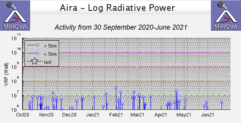 |
Figure 118. Clusters of low-intensity thermal anomalies were detected at Aira’s Sakurajima volcano during January-June 2021 based on the MIROVA graph (Log Radiative Power). The number of relatively higher thermal anomalies seemed to decrease after April. Courtesy of MIROVA. |
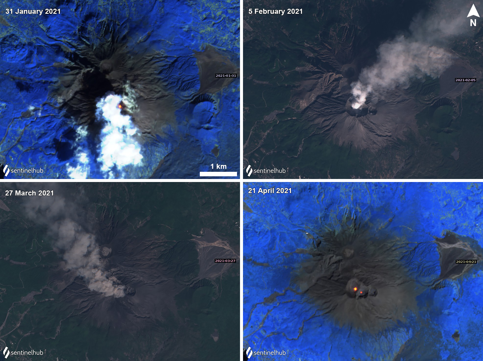 |
Figure 119. Sentinel-2 infrared satellite images showing white gas-and-steam plumes rising from Aira’s Sakurajima volcano on 31 January (top left) 2021 accompanied by a thermal anomaly in the summit crater and two thermal anomalies in the summit crater on 21 April (bottom right). On 5 February (top right) and 27 March (bottom left) natural color satellite images showed distinct ash plumes drifting NE and NW, respectively, due to explosive eruptions. Images using “Atmospheric penetration” (bands 12, 11, 8A) rendering on 31 January and 21 April, and “Natural Color” (bands 4, 3, 2) rendering on 5 February and 27 March. Courtesy of Sentinel Hub Playground. |
During January a total of 21 ash eruptions were detected, 18 of which were explosive. The number of volcanic earthquakes notably increased from 55 in December 2020 to 117, accompanied by white gas-and-steam emissions that rose 200 m above the crater and nighttime crater incandescence, as captured by a high-sensitivity surveillance camera. An explosion at 1642 on 4 January produced an ash plume that rose 1.8 km above the Minamidake crater. On 31 January an explosion at 0720 generated an ash plume that rose 2.3 km above the crater and ejected bombs 1.3-1.7 km high. JMA reported that sulfur dioxide emissions had been high since September 2020, and during January reported 1,500-5,000 tons/day, with the highest value recorded on 6 January. During seven days in the month, 3 g/m2 of ash fell, according to the Kagoshima Local Meteorological Observatory in Higashikorimoto (11 km WSW). Overall, about 100,000 tons of ash had fallen during the month.
Similar eruptive events continued in February, with 22 ash eruptions, 11 of which were explosive and ejected volcanic bombs 1-1.3 km from the Minamidake crater. The number of volcanic earthquakes increased to 292. During seven days of the month, ashfall was reported, accumulating to 11 g/m2; observation data showed that about 90,000 tons of ash had fallen during the month. SO2 emissions were between 1,100-4,300 tons/day, the higher of which was measured on 16 February. On 28 February an explosion at 2247 ejected bombs up to 1.3 km from the summit, produced an ash plume that rose 2.3 km above the crater, and was accompanied by crater incandescence.
Activity increased slightly during March and April, with 31 and 42 ash eruptions, respectively. The number of volcanic earthquakes decreased slightly from 195 in March to 148 in April. Explosions ejected incandescent material as far as 1.7 km from the Minamidake crater, accompanied by nighttime crater incandescence. An explosion on 5 March generated an ash plume that rose 2.7 km above the crater and ejected material as far as 1.1 km from the summit. On 27 March an eruption at 0236 produced an ash plume that rose 2.5-4 km above the crater and drifted NW, resulting in a large amount of ashfall in Kagoshima City (10 km W) (figure 120). Bombs were ejected up to 1.3 km from the crater. On 29 March at 1557 an ash plume rose 2.2 km above the crater and drifted SE, an accompanying pyroclastic flow was observed down the SE flank and ashfall was reported in Kagoshima City and the Kagoshima Prefecture. An explosion on 30 March at 0433 generated an ash plume 2.7 km above the crater and drifted E, ejecting material as far as 900 m from the crater and resulting in ashfall in Kagoshima City. Ashfall was reported on 14 days in March (21 g/m2) and 22 days in April (42 g/m2). A single thermal alert was detected by the MODVOLC system on 4 April; an explosion the following morning at 0641 on 5 April produced an ash plume 3 km above the crater. On 25 April an explosion at 0109 ejected material 1-1.3 km from the crater and an ash plume 2.3 km high. The explosion generated what was initially described as a pyroclastic flow that descended 1.8 km down the SW side of the crater; later field inspections did not observe pyroclastic flow deposits or damaged vegetation, and concluded that the plume was generated by winds. About 110,000-120,000 tons of ash was measured during the two months, and sulfur dioxide emissions remained consistent at 1,800-2,900 tons/day, according to JMA.
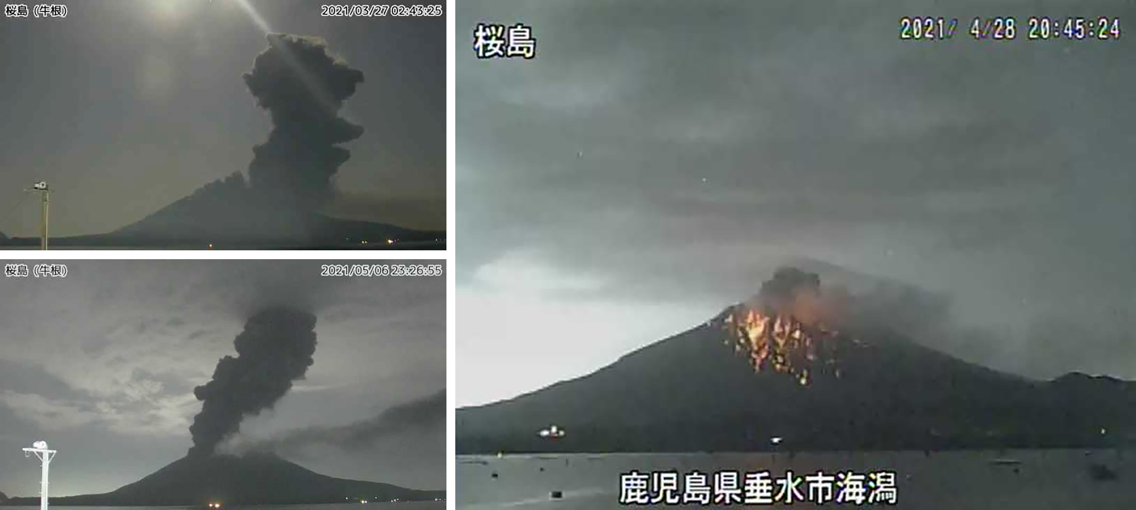 |
Figure 120. Webcam images of Aira’s Sakurajima volcano showing dense gray ash plumes on 27 March (top left) rising 3.2 km above the crater, on 6 May (bottom left) rising 2.5 km above the crater, and on 28 April (right) 2021 incandescent material was visible on the flanks of the volcano accompanied by a small ash plume. Images courtesy of JMA (Sakurajima March, April, and May 2021 monthly reports). |
During May and June, the number of eruptive events declined; 11 eruptions were detected during May, six of which were explosive and ejected material 800-1,100 m from the crater. On 6 May an explosion produced an ash plume that rose 2.5 km above the crater (figure 120). In June small, intermittent eruptions were detected, though none were explosive. Resulting ash plumes rose 1-2.5 km above the crater and were accompanied by nighttime crater incandescence, based on imagery from a high-sensitivity surveillance camera. The number of volcanic earthquakes continued to decrease each month from 91 to 18, respectively. During May ashfall was reported for four days, accumulating to 16 g/m2; about 50,000 tons of ash was measured. Less than 0.5 g/m2 was reported over the course of a day in June. SO2 emissions also gradually decreased from May at 1,300 tons/day to 600-2,700 tons/day in June.
Geological Summary. The Aira caldera in the northern half of Kagoshima Bay contains the post-caldera Sakurajima volcano, one of Japan's most active. Eruption of the voluminous Ito pyroclastic flow accompanied formation of the 17 x 23 km caldera about 22,000 years ago. The smaller Wakamiko caldera was formed during the early Holocene in the NE corner of the caldera, along with several post-caldera cones. The construction of Sakurajima began about 13,000 years ago on the southern rim and built an island that was joined to the Osumi Peninsula during the major explosive and effusive eruption of 1914. Activity at the Kitadake summit cone ended about 4,850 years ago, after which eruptions took place at Minamidake. Frequent eruptions since the 8th century have deposited ash on the city of Kagoshima, located across Kagoshima Bay only 8 km from the summit. The largest recorded eruption took place during 1471-76.
Information Contacts: Japan Meteorological Agency (JMA), 1-3-4 Otemachi, Chiyoda-ku, Tokyo 100-8122, Japan (URL: http://www.jma.go.jp/jma/indexe.html); Hawai'i Institute of Geophysics and Planetology (HIGP) - MODVOLC Thermal Alerts System, School of Ocean and Earth Science and Technology (SOEST), Univ. of Hawai'i, 2525 Correa Road, Honolulu, HI 96822, USA (URL: http://modis.higp.hawaii.edu/); MIROVA (Middle InfraRed Observation of Volcanic Activity), a collaborative project between the Universities of Turin and Florence (Italy) supported by the Centre for Volcanic Risk of the Italian Civil Protection Department (URL: http://www.mirovaweb.it/); Sentinel Hub Playground (URL: https://www.sentinel-hub.com/explore/sentinel-playground).