Report on Merapi (Indonesia) — September 2021

Bulletin of the Global Volcanism Network, vol. 46, no. 9 (September 2021)
Managing Editor: Edward Venzke.
Edited by A. Elizabeth Crafford.
Merapi (Indonesia) Dome growth, incandescent avalanches, and block-and-ash flows during March-August 2021
Please cite this report as:
Global Volcanism Program, 2021. Report on Merapi (Indonesia) (Crafford, A.E., and Venzke, E., eds.). Bulletin of the Global Volcanism Network, 46:9. Smithsonian Institution. https://doi.org/10.5479/si.GVP.BGVN202109-263250
Merapi
Indonesia
7.54°S, 110.446°E; summit elev. 2910 m
All times are local (unless otherwise noted)
Merapi volcano in central Java, Indonesia, has a lengthy history of major eruptive episodes. Activity has included lava flows, pyroclastic flows, lahars, Plinian explosions with heavy ashfall, incandescent block avalanches, block-and-ash flows, and dome growth and destruction. Fatalities from these events were reported in 1994, 2006, and in 2010 when hundreds of thousands of people were evacuated. Renewed phreatic explosions in May 2018 cancelled airline fights and generated significant SO2 plumes. A new lava dome appeared in early August 2018; gradual dome growth and destruction was accompanied by block avalanches, block-and-ash flows, periodic explosions, and pyroclastic flows. Two new domes appeared in early 2021, one inside the summit crater and one at the top of the SW flank. Activity during March-August 2021 is covered in this report with Information provided by Balai Penyelidikan dan Pengembangan Teknologi Kebencanaan Geologi (BPPTKG), the Center for Research and Development of Geological Disaster Technology, a branch of PVMBG which specifically monitors Merapi, the Pusat Vulkanologi dan Mitigasi Bencana Geologi (PVMBG, also known as Indonesian Center for Volcanology and Geological Hazard Mitigation, CVGHM), MAGMA Indonesia, and the Darwin Volcanic Ash Advisory Centre (VAAC).
Two lava domes at the summit continued to grow during March-August 2021. On 17 February 2021 the volume of the dome on the SW flank was 397,500 m3, and the volume of the dome at the center of the summit crater was 426,000 m3. Six months later, on 1 September 2021, the SW dome volume was estimated at 1,440,000 m3 and the central dome volume was 2,842,000 m3 (figure 110). Tens of daily block avalanches, many incandescent, were recorded throughout the period, generally traveling 500-2,000 m down the flanks. Most of the activity was related to the SW flank dome, but there were also periods of activity on the SE flank produced by the central dome. Tens of block-and-ash flows also occurred each month, moving down the SW and SE flanks, some as far as 3 km from the summit. Ash from explosions and block-and-ash flows occasionally produced ashfall. Ash emissions increased substantially at the end of July and throughout August; the plumes resulted in ashfall over a larger area multiple times during August. The MODIS Log Radiative Power graph produced by the MIROVA project shows a marked increase in thermal activity during July and August (figure 111), corresponding to the increased number incandescent block avalanches and block-and-ash flows.
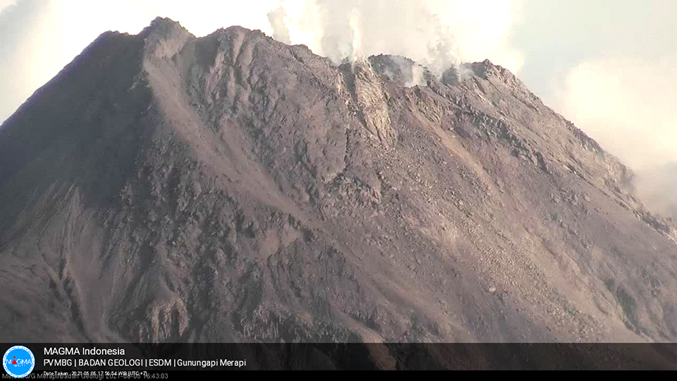 |
Figure 110. The active dome inside the summit crater at Merapi is visible within the steam plumes rising from the summit on 8 August 2021. The volumes of both the center dome and the SW flank dome continued to grow throughout March-August 2021. Courtesy of MAGMA Indonesia. |
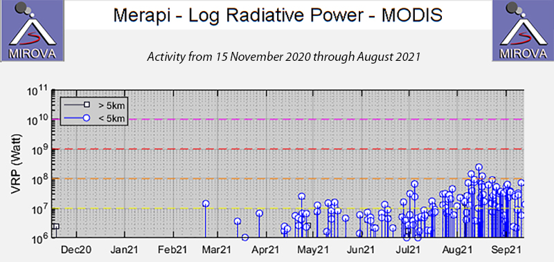 |
Figure 111. The MIROVA graph of Log Radiative Power for Merapi from 15 November 2020 through August 2021 showed a steady increase in thermal energy throughout the period. Explosive activity produced an increasing number of incandescent block avalanches and block-and-ash flows into August. Courtesy of MIROVA. |
The number of daily block avalanches during March 2021 ranged from a high of 210 on 5 March to a low of 97 on 20 March. On 6 March incandescent blocks were observed 24 times on the SW flank, traveling up to 1,000 m and on 8 March they were noted 20 times in the same place. Every day from 16 March through the end of the month, multiple incandescent block avalanches were reported. Most frequently, they descended 800-1,200 m down the SW flank, and were also periodically observed inside the summit crater on the growing central dome. Sentinel-2 satellite imagery showed a faint thermal anomaly on the SW flank on 19 March (figure 112), likely due to incandescent blocks and block-and-ash flows. Larger explosions on 27 March produced 27 incandescent block avalanches, with another 33 observed on 30 March.
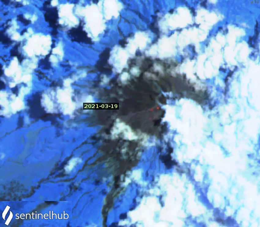 |
Figure 112. A faint thermal anomaly on the SW flank of Merapi near the summit on 19 March 2021 was likely caused by incandescent block avalanches from the growing SW-flank dome. Image uses Atmospheric penetration rendering (bands 12, 11, 8a). Courtesy of Sentinel Hub Playground. |
Thirty-four different block-and-ash flows were reported on 14 days of March, usually one or two in a day. On 8 March, three block-and-ash flows traveled 1,300 m down the SW flank. Eight block-and-ash flows on 27 March extended 1,800 m down the SW flank (figure 113). On 30 March one block-and-ash flow traveled 1,500 m down the SW flank. During the last week of the month small amounts of ashfall were reported in Ngadirojo, Stabelan (4 km NW), Takeran, Tlogolele (5 km NW), Selo (3 km NNW), Pos Babadan (4 km NW), and Pasar Talun (12 km W), and around Talun Market. Based on photos taken from the SW flank, the summit dome grew from 45 m high on 11 March to 70 m high on 1 April. The Darwin VAAC issued an ash advisory on 27 March based on a ground report of ash emissions that rose to 3.7 km altitude. PVMBG reported the ash plume 500 m above the summit.
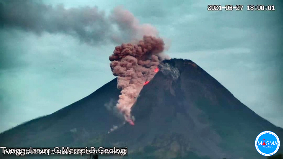 |
Figure 113. Eight block-and-ash flows were recorded at Merapi on 27 March 2021, producing minor ashfall to the NW and sending incandescent blocks down the SW flank. Courtesy of MAGMA Indonesia. |
Over 100 block avalanches occurred each day during April 2021, with few exceptions. The fewest, 74, occurred on 17 April, and the most, 225, occurred on 23 April. Incandescent block avalanches usually traveled 400-800 m down the SW flank. Sixteen were reported by BNPB on 2 April, and twenty were observed on 8 April, moving 700-1,000 m down the SW flank. On 12 April there were 29 incandescent block avalanches reaching 1,000 m down the SW flank; five more were observed 400 m down the SE flank. A total of 43 block-and-ash flows were noted on 17 days during the month, usually traveling 700-1,500 m from the summit. BNPB reported three block and ash flows on 2 April to a distance of 700-1,500 m down the SW flank (figure 114). Four of them traveled 1,800 m down the SW flank on 13 April and six traveled 1,300 m from the summit on 20 April; four moved 1,000-2,000 m down the SW flank on 23 April. Small amounts of ashfall were reported in Ngipiksari, Klangon, and Deles on 3 April 2021. An explosion on 23 April produced block-and-ash flows that traveled 2 km down the SW flank, produced an ash plume that rose 300 m above the summit, and caused ashfall in the Cepogo area of the Boyolali Regency in central Java.
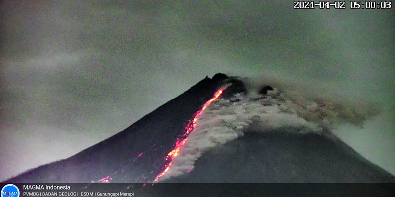 |
Figure 114. Sixteen incandescent block avalanches and three block-and-ash flows were reported on 2 April 2021 at Merapi. Courtesy of BNPB. |
Between 101 and 165 block avalanches were recorded daily during May 2021. PVMBG reported block-and-ash flows traveling 1,700 m on the SW flank on 1 May, and incandescent blocks traveling 600 m down the SW and SE flanks. Incandescent blocks and block-and-ash flows were observed daily during 4-9 May moving 700-2,000 m on the SW flank, and 700 m on the SE flank on 9 May. Similar activity occurred during 14-19, 22, and 27-31 May. Seventeen days of the month had block-and-ash flows, with a total of 31 reported.
The number of block avalanches reported each day during June 2021 ranged from 103 on 1 June to 377 on 30 June. The number was between 100-200 during the first half of the month but rose to over 200 about half the time during the second half of the month, with two days over 300 reported. Incandescent block avalanches were observed multiple times every day with blocks sliding 500-2,000 m down both the SW and SE flanks. Block-and-ash flows also increased in number and frequency during June, compared with the previous months. A total of 85 were reported on all but four days of the month. During most days 1-5 were reported, except 17 were noted on 30 June. The block-and-ash flows sent debris 900-3,000 m down the SW and SE flanks (figure 115). BNPB reported two block-and-ash flows early on 20 June that traveled 2,500 and 1,500 m down the SW flank. Four block-and-ash flows traveled 3 km SE on 25 June (figure 116). The larger explosions that day produced an ash plume that rose to 1 km above the summit (3.9 km altitude) and drifted SE resulting in ashfall in several areas on the SE flank. An ash emission on 29 June rose to 3.4 km altitude and drifted W. The next day 17 block-and-ash flows descended 900-1,500 m down both the SW and SE flanks.
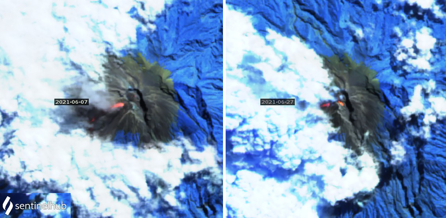 |
Figure 115. Incandescent block avalanches and block-and-ash flows at Merapi produced significant thermal anomalies on both the SW and SE flanks on 7 (left) and 27 (right) June 2021. Sentinel-2 satellite images use Atmospheric penetration rendering (bands 12, 11, 8a). Courtesy of Sentinel Hub Playground. |
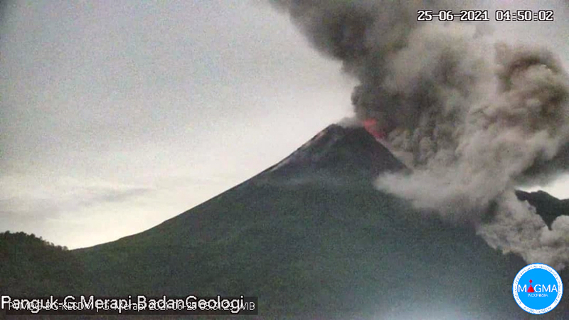 |
Figure 116. Four block-and-ash flows sent debris 3 km SE at Merapi on 25 June 2021. Courtesy of BNPB. |
For the first 20 days of July, the daily number of block avalanches was usually over 200, reaching a high of 338 on 10 July. Multiple incandescent block avalanches occurred on both the SW and SE flanks, extending as far as 2 km on many days (figure 117). Far fewer block-and-ash-flows occurred in July than were reported in June; only 19 during 1-5, 9, 26, and 29 July moving as far as to 2 km down the SW flank. BNPB reported block-and-ash flows on 8 and 9 July that traveled 1,100 m down the SW flank. The Darwin VAAC reported an ash emission on 24 July that rose to 3.0 km altitude and drifted WSW. Incandescent block avalanches caused fires on the SW flank on 25 July about 2.5 km from the summit.
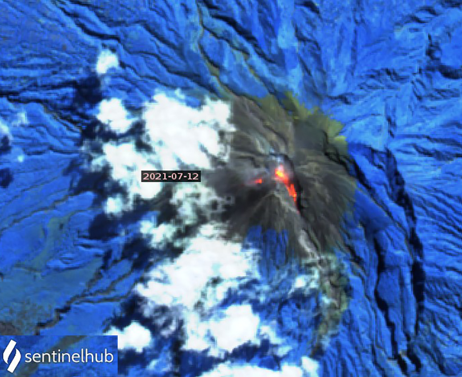 |
Figure 117. Multiple incandescent block avalanches descended both the SW and SE flanks of Merapi during July 2021. On 12 July the blocks traveled 1,700 m down the SW flank and 1,200 m down the SE flank creating significant thermal anomalies in this Sentinel-2 image that uses Atmospheric penetration rendering (bands 12, 11, 8a). Courtesy of Sentinel Hub Playground. |
Incandescent block avalanches were reported daily during August, reaching 1-2 km down the SW flank (figure 118). The number of daily block avalanches reported ranged from 61 to 385, exceeding 200 every day after 8 August (figure 119). Fifty-one block-and-ash flows were observed during sixteen days of August. Six were reported on 5 August, 7 on 12 August and 9 on 13 August. During other days 1-3 were observed. Most were reported moving 1,400 m down the SW flank. The largest events on 8, 10, and 12 August produced block-and-ash flows that traveled 2.5-3 km from the summit. They also traveled over 2 km from the summit on the SW flank on 13-15, 20, and 28 August.
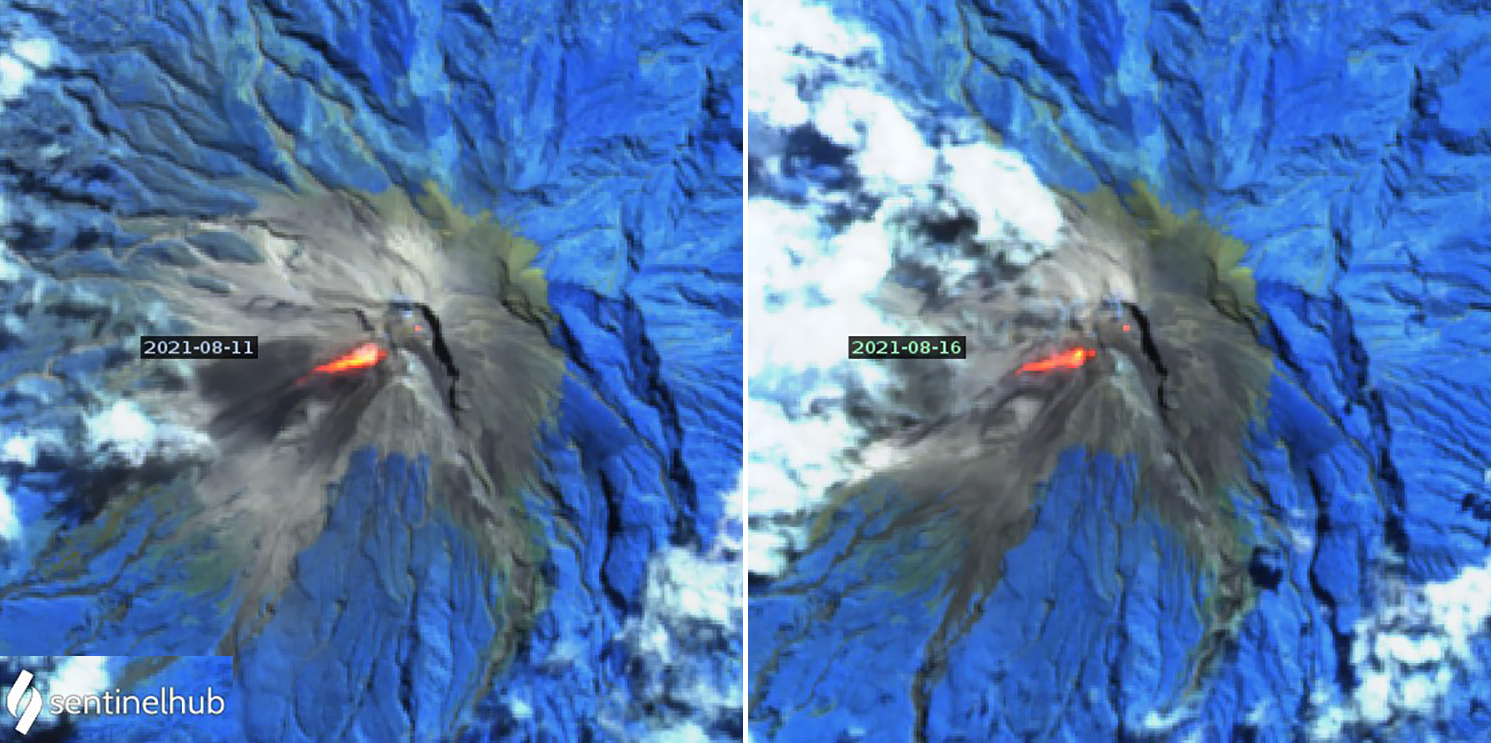 |
Figure 118. A large number of incandescent block avalanches and block-and-ash flows descended the SW flank of Merapi during August 2021. They were detected as large thermal anomalies in Sentinel-2 satellite images on 11 (left) and 16 (right) August. In addition, smaller anomalies were present at the summit crater dome. Images use Atmospheric penetration rendering (bands 12, 11, 8a). Courtesy of Sentinel Hub playground. |
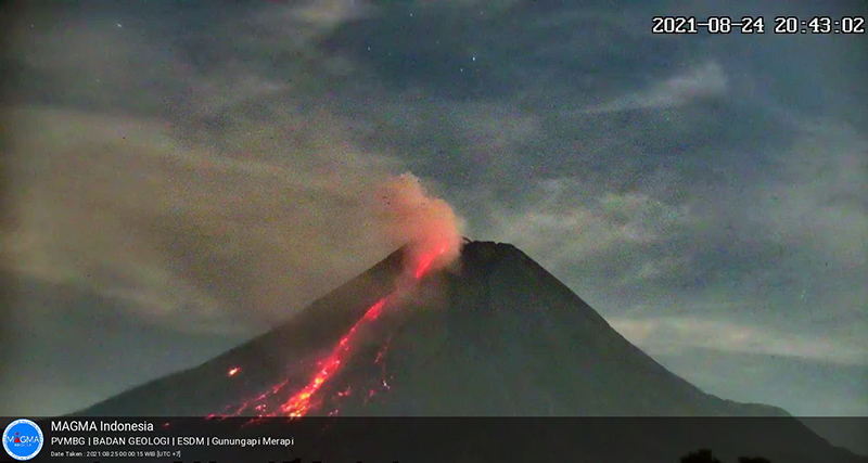 |
Figure 119. Incandescent block avalanches traveled hundreds of meters down the SW flank of Merapi daily throughout August, including on 24 August 2021, shown here. Courtesy of MAGMA Indonesia. |
The number of ash emissions increased significantly during August 2021, and ashfall was reported in surrounding communities on multiple occasions. The Darwin VAAC noted ash emissions continuously during 6-11, 14-19, and 28-29 August. They reported a minor ash emission visible in the webcam on 3 August that was not observed in satellite data, although a significant hotspot was apparent. An ash emission on 6 August rose to 4.3 km altitude and drifted SE. The next day a new emission rose to 3.7 km altitude and drifted NW; it was still clearly visible in satellite imagery early on 8 August moving WNW. Multiple discrete emissions were identifiable in satellite imagery throughout the day at 3.9 km altitude drifting W. An emission on 9 August rose to 3.0 km altitude and drifted WNW. The next day an emission that rose to 3.9 km altitude was discernible on multispectral satellite imagery. This was followed by another ash plume moving NW at 4.3 km altitude. On 11 August ash was observed in satellite imagery drifting NW at 3.0 km altitude. Later that day a plume appeared in satellite imagery moving SW at 4.3 km altitude. A new ash emission rose to 3.0 km altitude and drifted WSW on 14 August; the next day one rose to 3.7 km and drifted W. Ash to a similar altitude drifted W on 16 August and continued to be observed through 18 August, drifting SW (figure 120). On 19 August block-and-ash flows produced an ash plume near summit. Continuous ash emission was reported on 28 August drifting SW and W at 3.7 km altitude. An ash plume rose to 3.0 km altitude and drifted SW late in the day and continued into 29 August drifting NW before dissipating.
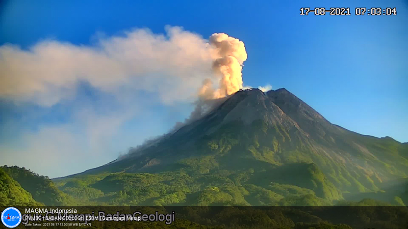 |
Figure 120. Continuous ash emissions were reported by the Darwin VAAC during 14-19 August 2021 at Merapi. On 17 August block-and-ash flows descended the SW flank while dense white steam and diffuse ash rose from the summit area and drifted W. Courtesy of MAGMA Indonesia. |
BNPB reported that 19 villages received ashfall on 11 August after block-and-ash flows traveled 2.5 km down the SW flank, sending ash emissions to 4.3 km altitude the previous day (figure 121). The communities were located in the Magelang Regency of central Java and included Paten and Sengi Villages in Dukun District; Ketep and Wonolelo Villages, Sawangan District; Pakis, Gejagan, Rejosari, Banyusidi, Ketundan, Petung and Daleman Kidul Villages in Pakis District; Pucungsari, Pesidi, and Lebak Villages in Grabag District; Kaliurang Village in Srumbung District; Kebonagung Village in Tegalrejo District; and Karangkajen, Donorejo, and Krincing Villages in the Secang District. On 10 and 12 August ashfall was also reported in Salam, Muntilan, and Mungkid. During the week of 13-19 August there were 20 block-and-ash flows that sent blocks as far as 3.5 km. Ashfall was reported on 16 August in the Dukun, Sawangan, Tegalrejo, Secang, Gowok, and Mertoyudan sub-districts in the Magelang District, and also in Selo, Boyolali, and Mojotengah in Wonosobo District. In addition, the sub-districts of Temanggung, Kedu, Pringsurat, Bulu, Tlogomulyo, Kranggan, and Parakan in Temanggung Regency were affected by ash. Ashfall was reported on 28 August and 1 September in several areas including in Srumbung, Salam, Ngluwar, Dukun, Mungkid, Sawangan, Muntilan, and Salaman sub-districts.
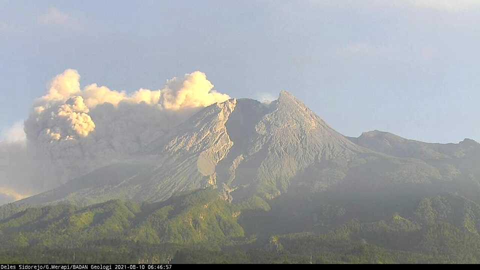 |
Figure 121. Substantial ash emissions from block-and-ash flows on the SW flank of Merapi on 10 August 2021 produced ashfall in numerous nearby villages. Courtesy of PBBTKG. |
Geological Summary. Merapi, one of Indonesia's most active volcanoes, lies in one of the world's most densely populated areas and dominates the landscape immediately north of the major city of Yogyakarta. It is the youngest and southernmost of a volcanic chain extending NNW to Ungaran volcano. Growth of Old Merapi during the Pleistocene ended with major edifice collapse perhaps about 2,000 years ago, leaving a large arcuate scarp cutting the eroded older Batulawang volcano. Subsequent growth of the steep-sided Young Merapi edifice, its upper part unvegetated due to frequent activity, began SW of the earlier collapse scarp. Pyroclastic flows and lahars accompanying growth and collapse of the steep-sided active summit lava dome have devastated cultivated lands on the western-to-southern flanks and caused many fatalities.
Information Contacts: Balai Penyelidikan dan Pengembangan Teknologi Kebencanaan Geologi (BPPTKG), Center for Research and Development of Geological Disaster Technology (URL: http://merapi.bgl.esdm.go.id/, Twitter: @BPPTKG); Pusat Vulkanologi dan Mitigasi Bencana Geologi (PVMBG, also known as Indonesian Center for Volcanology and Geological Hazard Mitigation, CVGHM), Jalan Diponegoro 57, Bandung 40122, Indonesia (URL: http://www.vsi.esdm.go.id/); MAGMA Indonesia, Kementerian Energi dan Sumber Daya Mineral (URL: https://magma.esdm.go.id/v1); Badan Nasional Penanggulangan Bencana (BNPB), National Disaster Management Agency, Graha BNPB - Jl. Scout Kav.38, East Jakarta 13120, Indonesia (URL: http://www.bnpb.go.id/); MIROVA (Middle InfraRed Observation of Volcanic Activity), a collaborative project between the Universities of Turin and Florence (Italy) supported by the Centre for Volcanic Risk of the Italian Civil Protection Department (URL: http://www.mirovaweb.it/); Darwin Volcanic Ash Advisory Centre (VAAC), Bureau of Meteorology, Northern Territory Regional Office, PO Box 40050, Casuarina, NT 0811, Australia (URL: http://www.bom.gov.au/info/vaac/); Sentinel Hub Playground (URL: https://www.sentinel-hub.com/explore/sentinel-playground).