Report on Villarrica (Chile) — September 2021

Bulletin of the Global Volcanism Network, vol. 46, no. 9 (September 2021)
Managing Editor: Edward Venzke.
Edited by A. Elizabeth Crafford.
Villarrica (Chile) Activity declines; thermal anomalies persist during March-August 2021
Please cite this report as:
Global Volcanism Program, 2021. Report on Villarrica (Chile) (Crafford, A.E., and Venzke, E., eds.). Bulletin of the Global Volcanism Network, 46:9. Smithsonian Institution. https://doi.org/10.5479/si.GVP.BGVN202109-357120
Villarrica
Chile
39.42°S, 71.93°W; summit elev. 2847 m
All times are local (unless otherwise noted)
Eruptions documented at Chile's Villarrica since 1558 have consisted largely of mild-to-moderate explosive activity with occasional lava effusion. An intermittently active lava lake at the summit has been the source of Strombolian activity, incandescent ejecta, and thermal anomalies for several decades; the current eruption has been ongoing since December 2014. Continuing low-level activity during March-August 2021 is covered in this report, with information provided by the Southern Andes Volcano Observatory (Observatorio Volcanológico de Los Andes del Sur, OVDAS), part of Chile's National Service of Geology and Mining (Servicio Nacional de Geología y Minería, SERNAGEOMIN), and Projecto Observación Villarrica Internet (POVI), part of the Fundacion Volcanes de Chile, a private research group that studies volcanoes across Chile. Sentinel satellite imagery also provided valuable data.
Activity decreased at Villarrica during March-August 2021, with no explosions reported, and rare incandescence at night. Low levels of seismicity, emissions, SO2, and thermal activity led SERNAGEOMIN to lower the Alert Level from Yellow to Green (on a 4-Level scale) in mid-April, and reduce the warning area to 100 m around the summit crater. They reported that analysis of satellite data in late February 2021 indicated that the surface of the lava lake was about 70-80 m below the crater rim. Persistent weak thermal anomalies in satellite data suggested that the lava lake remained at a deep level throughout the period.
Incandescence at night was reported once during the first half of March, and then not again through August. The number of LP seismic events decreased steadily each month from 6,986 events recorded during March to 172 events recorded during August 2021. Tremor and acoustic signals remained low, and VT seismic events were intermittent with six reported in early March, one or two each month during April-June, 4 in July, and 11 in August. Emissions were white, of variable intensity, and with little or no particulate material. Plumes reached about 1,000 m above the crater most months, dropping to less than 600 m during July and August. Thermal anomalies in Sentinel-2 satellite data were the only consistent evidence of activity throughout the period; anomalies were present in all clear satellite images. The intensity of the anomalies varied, and occasional steam plumes were also present (figure 114). A single series of thermal images from the POVI infrared webcam on 7 August was consistent with the interpretation of the deep level of the lava lake within the crater (figure 115).
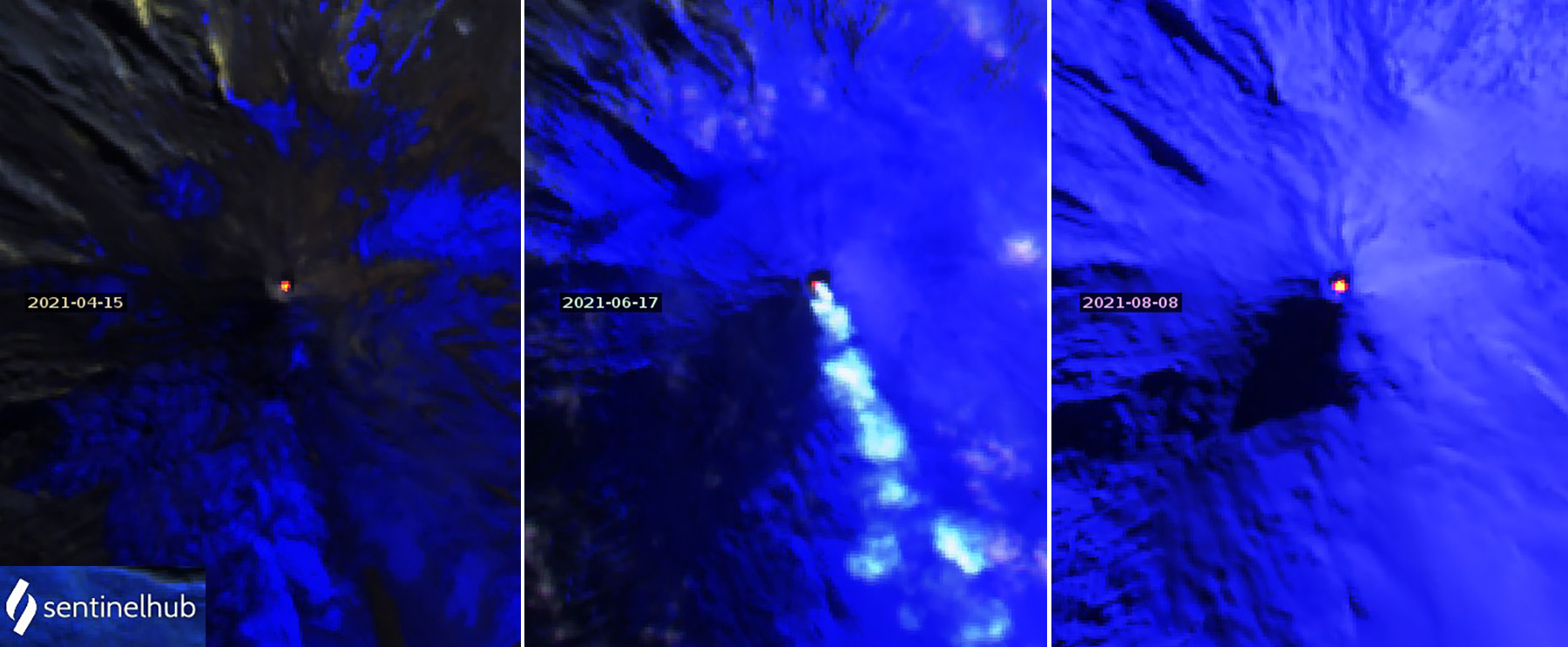 |
Figure 114. Thermal anomalies of varying intensity appeared in all clear Sentinel-2 satellite images of Villarrica during March-August 2021. A weak anomaly on 15 April (left), a steam plume with an anomaly on 17 June (center), and a bright anomaly on 8 August (right) show the range of values. Images use Atmospheric penetration rendering (bands 12, 11, 8a). Courtesy of Sentinel Hub Playground. |
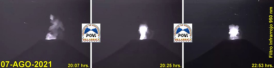 |
Figure 115. Low levels of incandescence recorded by the POVI webcam at Villarrica on 7 August 2021 were characteristic of the lava lake surface being located near the bottom of the crater. Courtesy of POVI. |
Geological Summary. The glacier-covered Villarrica stratovolcano, in the northern Lakes District of central Chile, is ~15 km south of the city of Pucon. A 2-km-wide caldera that formed about 3,500 years ago is located at the base of the presently active, dominantly basaltic to basaltic andesite cone at the NW margin of a 6-km-wide Pleistocene caldera. More than 30 scoria cones and fissure vents are present on the flanks. Plinian eruptions and pyroclastic flows that have extended up to 20 km from the volcano were produced during the Holocene. Lava flows up to 18 km long have issued from summit and flank vents. Eruptions documented since 1558 CE have consisted largely of mild-to-moderate explosive activity with occasional lava effusion. Glaciers cover 40 km2 of the volcano, and lahars have damaged towns on its flanks.
Information Contacts: Servicio Nacional de Geología y Minería (SERNAGEOMIN), Observatorio Volcanológico de Los Andes del Sur (OVDAS), Avda Sta María No. 0104, Santiago, Chile (URL: http://www.sernageomin.cl/); Proyecto Observación Villarrica Internet (POVI) (URL: http://www.povi.cl/); Sentinel Hub Playground (URL: https://www.sentinel-hub.com/explore/sentinel-playground).