Report on Pavlof (United States) — November 2021

Bulletin of the Global Volcanism Network, vol. 46, no. 11 (November 2021)
Managing Editor: Benjamin Andrews.
Edited by Kadie L. Bennis.
Pavlof (United States) Intermittent minor explosions and gas-and-ash emissions during August-October 2021
Please cite this report as:
Global Volcanism Program, 2021. Report on Pavlof (United States) (Bennis, K.L., and Andrews, B., eds.). Bulletin of the Global Volcanism Network, 46:11. Smithsonian Institution. https://doi.org/10.5479/si.GVP.BGVN202111-312030
Pavlof
United States
55.417°N, 161.894°W; summit elev. 2493 m
All times are local (unless otherwise noted)
Pavlof is located on the Alaska Peninsula, about 970 km SW of Anchorage, and was constructed along a line of vents extending NE from the Emmons Lake caldera. The volcano is about 7 km in diameter and contains active vents on the N and E flanks near the summit. Historical eruptions have been characterized by Strombolian to Vulcanian explosions from the summit vents, along with occasional lava flows; the largest eruption took place in 1911 when a fissure opened on the N flank and ejected large blocks and effused lava. More recently, there was a short eruption from March to July 2016 that consisted of a strong ash plume and several smaller ash events (BGVN 42:03). This report updates information from December 2017 through October 2021, which includes low-level gas-and-ash emissions, minor explosions, and local ash deposits during the second half of 2021, based on daily and weekly reports from the Alaska Volcano Observatory (AVO) and satellite data.
Summary of activity during 2019. No activity was reported during December 2017 through April 2019, according to the AVO weekly reports, although Sentinel-2 infrared satellite imagery showed occasional high temperatures at the summit crater during December 2017 and through 2018 (figure 17). Low-frequency seismic tremor was initially detected on 16 May 2019 that prompted AVO to raise the Aviation Color Code (ACC) and Volcano Alert Level (VAL) to Yellow and Advisory, respectively. Webcam images showed a gas-and-steam plume rising from the summit and overnight satellite images indicated warm surface temperatures. This activity continued to be reported through 11 June 2019, after which seismicity declined to background levels. As a result, the ACC and VAL were lowered to Green and Normal, respectively. Gas-and-steam emissions continued intermittently, along with elevated surface temperatures, but were described as normal background behavior (figure 18). Small explosion signals were detected on infrasound and seismic networks on 19 October 2019, though no ash cloud was visible due to weather conditions. Clear satellite images and webcam images later that week also did not show any deposits associated with these events, according to AVO. Weakly elevated surface temperatures and small gas-and-steam plumes were visible, however, which continued to be detected through 30 October. On 28 December seismicity increased again, though no eruptive activity or emissions were reported, which caused AVO to raise the ACC and VAL to Yellow and Advisory, respectively.
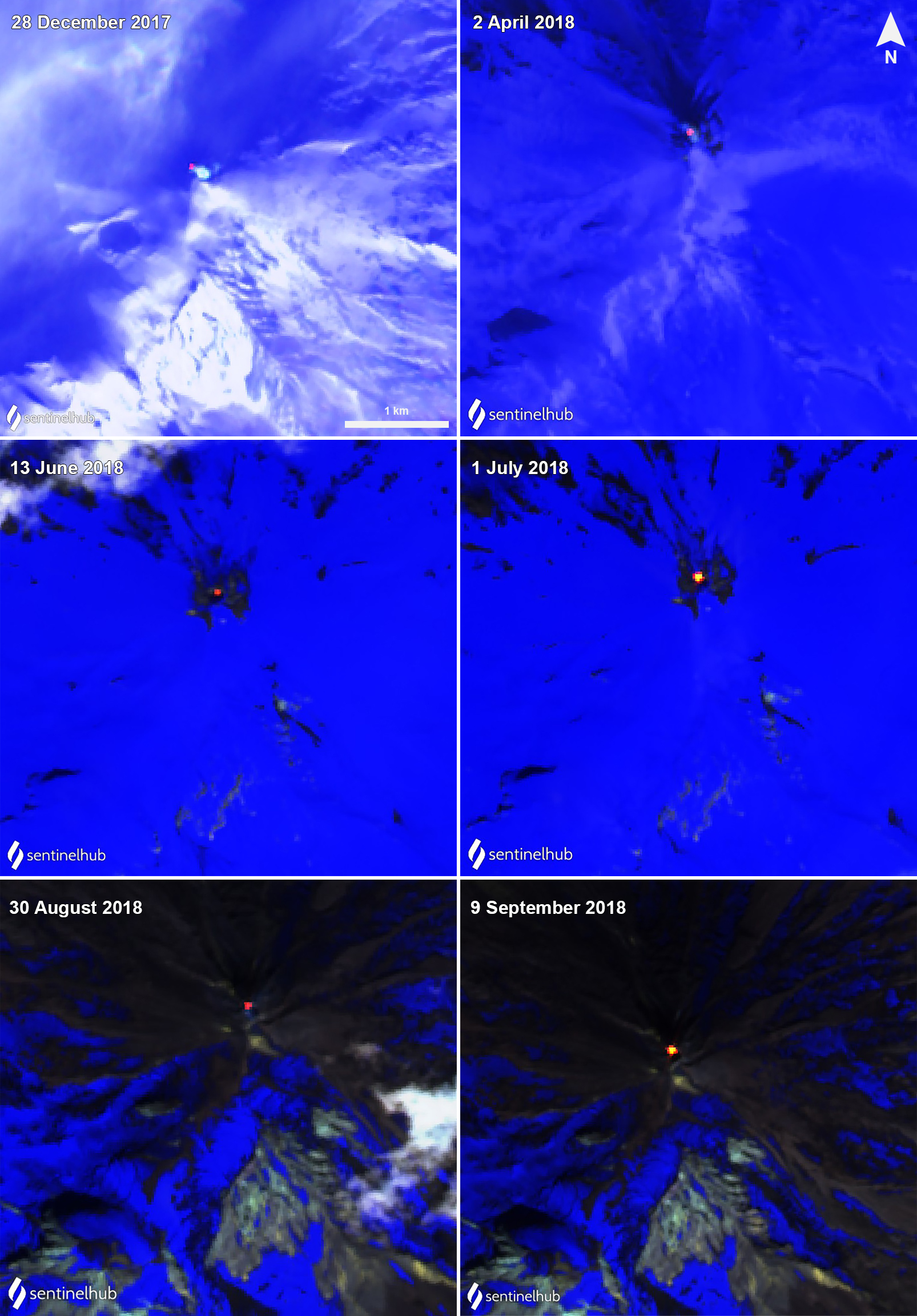 |
Figure 17. Sentinel-2 infrared satellite imagers showing a small, yet persistent thermal anomaly in the summit crater of Pavlof on 28 December 2017 (top left), 2 April (top right), 13 June (middle left), 1 July (middle right), 30 August (bottom left), and 9 September (bottom right) 2018. Some anomalies are accompanied by white gas-and-steam emissions. Sentinel-2 images with "Atmospheric penetration" (bands 12, 11, 8A) rendering. Courtesy of Sentinel Hub Playground. |
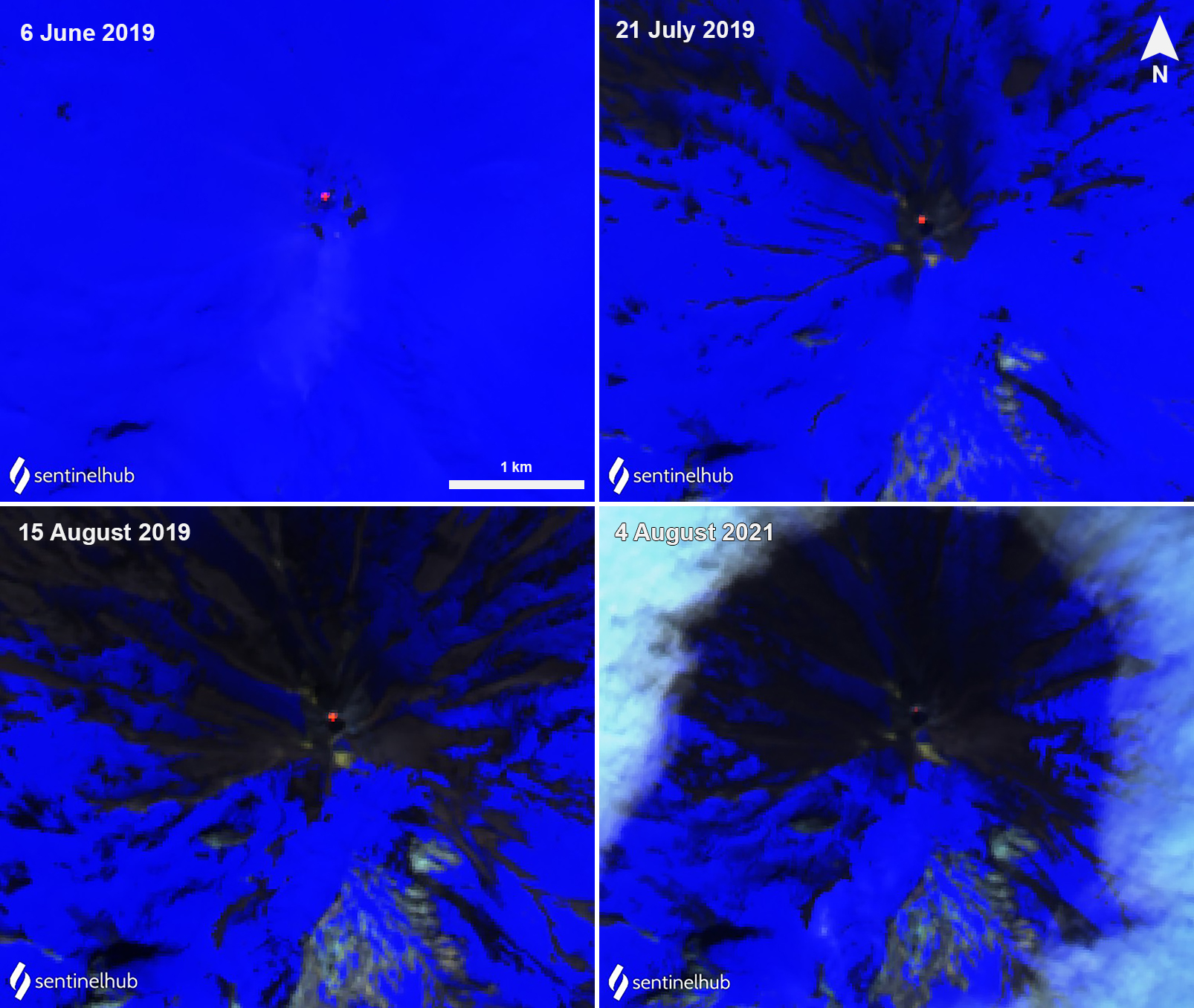 |
Figure 18. Sentinel-2 infrared satellite images showing a continued thermal anomaly in the summit crater of Pavlof on 6 June (top left), 21 July (top right), 15 August (bottom left) 2019 and renewed activity marked with a weaker anomaly on 4 August 2021 (bottom right). Sentinel-2 images with "Atmospheric penetration" (bands 12, 11, 8A) rendering. Courtesy of Sentinel Hub Playground. |
Summary of activity during 2020. Slightly elevated seismicity and surface temperatures continued to be reported through 2 March 2020. Little to no activity was detected from March through much of September. Then, increased seismic tremors accompanied by occasional small earthquakes were reported during 21-30 September, which prompted AVO to raise the ACC and VAL to Yellow and Advisory. Clouds often obscured the summit, but occasional gas-and-steam emissions were observed during clear weather.
Activity during July-October 2021. Activity remained low through most of 2021. On 9 July the ACC and VAL were raised to Yellow and Advisory, respectively, due to increased seismic activity and near-continuous tremor that was observed in infrasound and regional seismic data. No eruptive activity or emissions from the summit were observed, however. During the following week, intermittent periods of seismic tremor lasted tens of minutes to several hours and were accompanied by minor gas-and-steam emissions and elevated temperatures in the summit crater, as detected by satellite and webcam images. A thin deposit of ash, likely carried out by gas-and-steam emissions, was visible on the flank that extended a short distance from the summit crater on 18 July. Weakly elevated surface temperatures were detected on 19 July. A pilot on 23 July reported a small, resuspended ash cloud that rose 2 km altitude and extended 32-40 km SE, which was a result of high winds.
Sentinel-2 infrared satellite imagery showed renewed, but weak thermal activity beginning on 4 August (figure 18). During the morning of 5 August minor ash emissions were reported for an hour just above the summit and drifted almost 10 km SE before dissipating; seismic tremor and small explosions were detected by local seismic and infrasound instruments, according to AVO. This prompted AVO to raise the ACC and VAL to Orange and Watch, respectively. Local ash fallout was visible on the SE flank. Intermittent small explosions and low-level ash emissions continued to be reported during most of August, although cloud cover prevented a clear view of the activity. Weakly elevated surface temperatures were reported at night in satellite data. On 25 August an explosion generated an ash plume that rose to 3.7 km altitude, based on a pilot report.
Weather clouds often prevent clear views of the summit during September, but intermittent explosions and low-level ash emissions persisted. Elevated seismicity was detected but remained at low levels. A series of four minor ash emissions were visible in webcam images for a period of five hours on 10 September, which produced minor and diffuse ash emissions that rose from a vent on the E flank. A small explosion occurred early on 12 September that likely produced a minor ash cloud surrounding the vent near the summit, although views were obscured by clouds. During the morning of 18 September clear webcam views showed a recent ash deposit on the upper flanks that was associated with at least one minor ash emission event; periods of increased seismic tremor were also detected over the past day (figure 19). Subsequent ash emission events were noted in webcam images and by local observers at 0900 and 1500 on 19 September. Emissions remained low and dispersed quickly, though satellite images showed deposits on the surrounding flanks. Periods of increased tremor accompanied these ash emissions. During 22-23 September low level ash emissions rose possibly several hundred meters above the summit, according to webcam data. Small explosions were detected in seismic and infrasound data during 25-28 September; on 26 September explosions were visible in webcam images at 2016 and during the next morning at 0716. A small ash emission was observed in webcam images at 1601. Ash deposits resulting from the explosions were visible on the E and SE flanks (figure 20). Regional infrasound data also recorded a small explosion on 28 September.
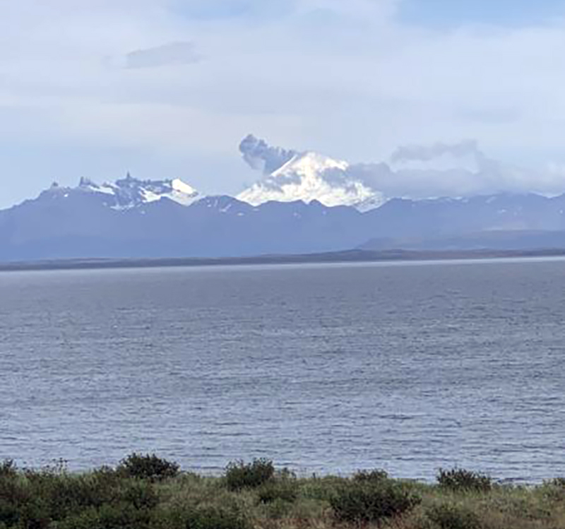 |
Figure 19. Photo of a small ash cloud rising above Pavlof on 18 September 2021 at 1513, as seen from Cold Bay, AK. Photo by Robert Nielsen, courtesy of AVO. |
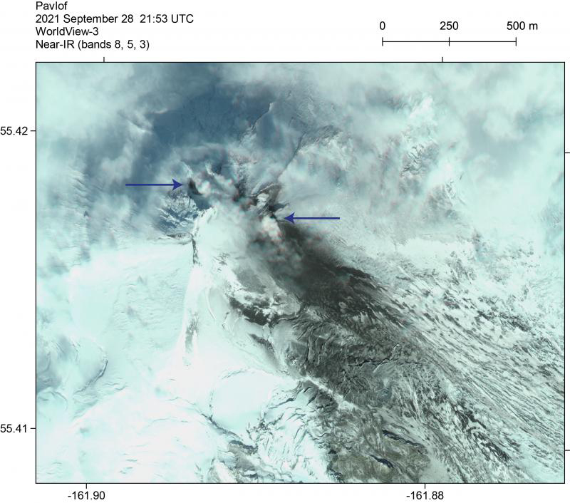 |
Figure 20. Worldview-3 near IR satellite image of Pavlof on 28 September 2021 showing ash deposits on the SE flanks from intermittent explosions and gas-and-steam plumes from the N and SE vents (blue arrows). Photo by Matt Loewen, courtesy of AVO. |
Activity during October consisted of minor gas-and-steam and ash emissions and intermittent minor explosions, although clouds often prevented clear views of the summit. As a result, low-level ash emissions and local ash deposits were visible on the flanks only during clear weather. Explosions during the latter half of October were focused at the vent on the upper SE flank, near the location of the 2007 vent. Seismicity remained elevated through the month, as well as slightly elevated surface temperatures.
Geological Summary. The most active volcano of the Aleutian arc, Pavlof is a Holocene stratovolcano that was constructed along a line of vents extending NE from the Emmons Lake caldera. Pavlof and Pavlof Sister to the NE form a dramatic pair of symmetrical, glacier-covered stratovolcanoes that overlook Pavlof and Volcano bays. Little Pavlof is a smaller cone on the SW flank of Pavlof volcano, near the rim of Emmons Lake caldera. Unlike Pavlof Sister, eruptions have frequently been reported from Pavlof, typically Strombolian to Vulcanian explosive eruptions from the summit vents and occasional lava flows. The active vents lie near the summit on the north and east sides. The largest recorded eruption took place in 1911, at the end of a 5-year-long eruptive episode, when a fissure opened on the N flank, ejecting large blocks and issuing lava flows.
Information Contacts: Alaska Volcano Observatory (AVO), a cooperative program of a) U.S. Geological Survey, 4200 University Drive, Anchorage, AK 99508-4667 USA (URL: https://avo.alaska.edu/), b) Geophysical Institute, University of Alaska, PO Box 757320, Fairbanks, AK 99775-7320, USA, and c) Alaska Division of Geological & Geophysical Surveys, 3354 College Rd., Fairbanks, AK 99709, USA (URL: http://dggs.alaska.gov/); Sentinel Hub Playground (URL: https://www.sentinel-hub.com/explore/sentinel-playground).