Report on Merapi (Indonesia) — March 2022

Bulletin of the Global Volcanism Network, vol. 47, no. 3 (March 2022)
Managing Editor: Edward Venzke.
Edited by Kadie L. Bennis.
Merapi (Indonesia) Dome growth, pyroclastic flows, lava avalanches, and ash emissions through February 2022
Please cite this report as:
Global Volcanism Program, 2022. Report on Merapi (Indonesia) (Bennis, K.L., and Venzke, E., eds.). Bulletin of the Global Volcanism Network, 47:3. Smithsonian Institution. https://doi.org/10.5479/si.GVP.BGVN202203-263250
Merapi
Indonesia
7.54°S, 110.446°E; summit elev. 2910 m
All times are local (unless otherwise noted)
The frequently active Merapi is located immediately north of the major city of Yogyakarta in central Java, Indonesia. Volcanism has included lava flows, pyroclastic flows, lahars, explosions with heavy ashfall, incandescent block avalanches, block-and-ash flows, and cycles of dome growth and destruction. The current eruption period began in December 2020 and has recently consisted of explosions, dome growth, incandescent avalanches, and block-and-ash flows (BGVN 46:09). Two new domes appeared in January and February 2021: one inside the summit crater and one at the top of the SW flank. This report updates similar activity from September 2021 through February 2022 using information primarily from Balai Penyelidikan dan Pengembangan Teknologi Kebencanaan Geologi (BPPTKG), the Center for Research and Development of Geological Disaster Technology, a branch of PVMBG which specifically monitors Merapi. Additional information came from the Pusat Vulkanologi dan Mitigasi Bencana Geologi (PVMBG, also known as Indonesian Center for Volcanology and Geological Hazard Mitigation, CVGHM), MAGMA Indonesia, and the Darwin Volcanic Ash Advisory Centre (VAAC).
BPPTKG reported that the two lava domes, located just below the SW rim and in the summit crater, continued to grow during September; the SW dome had grown 7 m taller and had an estimated volume of 1.6 million cubic meters and the summit lava dome had grown 1 m wider and had an estimated volume of 2.85 million cubic meters. A total of seven pyroclastic flows descended the SW flank as far as 2.5 km, and 67-144 lava avalanches traveled a maximum of 2 km SW. On 1 September ashfall was reported in several areas, including Srumbung, Salam, Ngluwar, Dukun, Mungkid, Sawangan, Muntilan, and the Salaman sub-districts. White gas-and-steam emissions rose 500 m high, based on observations from the Kaliurang Mount Merapi Observation Post. During 9-10 September a continuous ash emission was observed in satellite imagery and rose to 3 km altitude and drifted E and NW.
Both lava domes continued to grow during October; the SW dome had grown about 5 m higher, with an estimated volume of 1.67 million cubic meters, and the summit dome rose another 4 m with an estimated volume of 2.927 million cubic meters. Two pyroclastic flows descended 2.5 km down the SW flank. There were 30-76 lava avalanches reported that traveled a maximum of 2 km SW. White gas-and-steam emissions rose 700 m high. During 15-21 October a thin ash deposit was reported in the Selo area.
Similar activity continued during November, with active lava domes and 106-212 lava avalanches that traveled 2 km SW. Two pyroclastic flows were reported descending 1.5-2 km on the SW flank; one pyroclastic flow traveled 1.8 km down the SW flank on 13 November and another occurred on 20 November (figure 122). The estimated volume of the SW dome was 1.61 million cubic meters, with the summit dome at almost 2.93 million cubic meters.
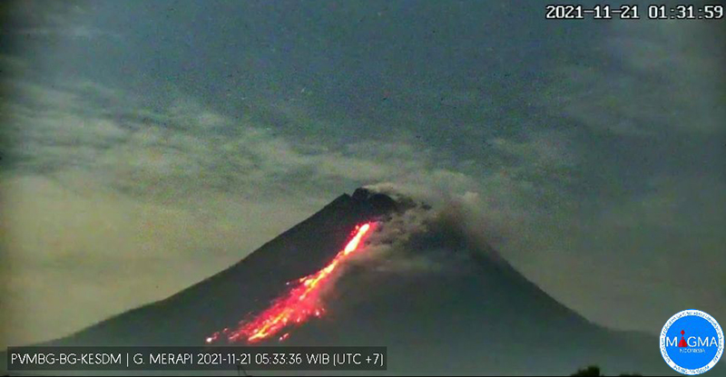 |
Figure 122. Webcam image of an incandescent lava avalanche descending the SW flank at Merapi on 21 November 2021, which generates ash plumes. Courtesy of MAGMA Indonesia. |
CVGHM reported a discrete ash plume that rose to 3.9 km altitude and drifted E on 1 December, but it was not detected in satellite imagery due to cloud cover. Two pyroclastic flows traveled 3 km down the SW flank on 1 December. According to a VONA issued by PVMBG, around 2104 on 1 December an ash plume rose 1 km above the summit and drifted E. The height of the SW lava dome decreased about 2 m during 26 November and 2 December, but the estimated volumes at both remained stable at 1.63 million cubic meters for the SW dome and just over 3 million cubic meters for the summit dome. Between 112-190 lava avalanches moved as far as 2 km SW down the Bebeng drainage. On 6 December a pyroclastic flow traveled 1.8 km down the Bebeng drainage on the SW flank at 1644, which lasted two minutes and forty seconds, based on seismic data, according to BPPTKG. At 1643 on 18 December a pyroclastic flow advanced 2 km SW, which produced an ash plume that rose 400 m high (figure 123). During 24-30 December the height of the SW lava dome had decreased by 3 m.
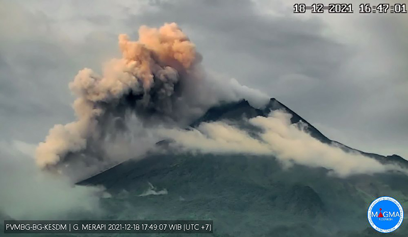 |
Figure 123. Webcam image of a pyroclastic flow at Merapi extending 2 km down the SW flank, which generated a 400-m-high ash plume on 18 December 2021. Courtesy of MAGMA Indonesia. |
Observations during early January 2022 showed that the height of the SW lava dome had increased about 2 m between 31 December and 6 January 2022. Seismicity was recorded at higher levels with more intense earthquakes compared to the previous months. The estimated volume of the SW dome was over 1.67 million cubic meters and just over 3 million cubic meters at the summit dome. The weekly number of detected lava avalanches ranged between 30 and 123, which traveled a maximum of 2.2 km SW down the Bebeng drainage (figure 124). A total of seven pyroclastic flows were reported descending 2-2.5 km down the SW flank.
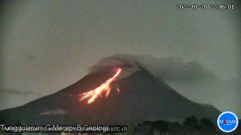 |
Figure 124. Webcam image of an incandescent lava avalanche moving down the SW flank at Merapi on 28 January 2022. Courtesy of MAGMA Indonesia. |
In February, no significant morphological changes were detected at the lava domes, though seismicity remained relatively high. The estimated volumes of the SW and summit domes was 1.58 million cubic meters and 3.23 million cubic meters, respectively. In the Bebeng drainage, 105-173 weekly lava avalanches were reported, moving as far as 2 km SW, and one of which went 300 m NW. Nine pyroclastic flows extended 1.8-2.8 km. On 2 February the Darwin VAAC issued a notice describing resuspended ash that rose to 3.7 km altitude based on satellite data; no eruption was associated with this event. A ground report indicated that on 6 February ash plumes rose 600 m above the summit and drifted E, though it was likely resuspended. Ashfall was reported in multiple areas within about 20 km to the S, SE, and E, including the Cangkringan, Sleman and Musuk districts. On 18 February minor ashfall was reported in the Pakem District.
The MODIS Log Radiative Power graph produced by the MIROVA project showed that thermal activity was stronger and more frequent during September-October 2021 compared to December through February 2022 (figure 125). This pattern is also reflected in the MODVOLC hotspot detection program, which detected a total of 25 thermal anomalies over the days of 3, 10, 17, and 30 September, 5, 14, 21, 28, and 30 October, 29 November, 26 December 2021, 2 and 9 January, and 24 February 2022. This thermal activity was also detected in Sentinel-2 infrared satellite imagery representing incandescent lava and block avalanches dominantly moving down the SW flank (figure 126).
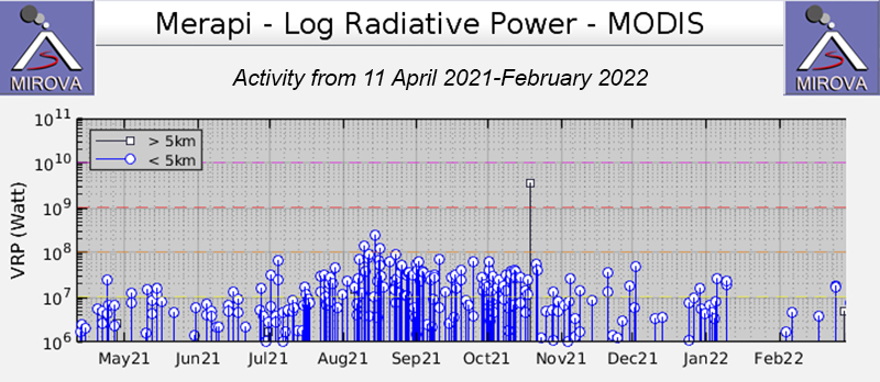 |
Figure 125. Frequent low- to moderate-power thermal anomalies at Merapi persisted during September 2021 through February 2022, according to the MIROVA graph (Log Radiative Power). The frequency of the anomalies visibly decreased during mid-October and there was a break in activity during January. The overall strength of the anomalies also declined from September through February. Courtesy of MIROVA. |
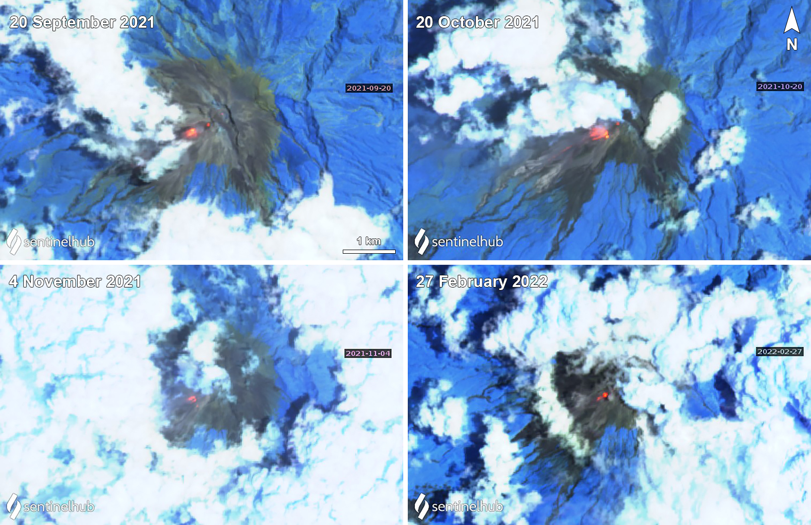 |
Figure 126. Incandescent block avalanches and block-and-ash flows at Merapi produced significant thermal anomalies, mainly on the SW flank. Examples from Sentinel-2 infrared satellite imagery are shown here for 20 September (top left), 20 October (top right), 4 November (bottom left) 2021, and 27 February (bottom right) 2022. Sentinel-2 satellite images use Atmospheric penetration rendering (bands 12, 11, 8a). Courtesy of Sentinel Hub Playground. |
Geological Summary. Merapi, one of Indonesia's most active volcanoes, lies in one of the world's most densely populated areas and dominates the landscape immediately north of the major city of Yogyakarta. It is the youngest and southernmost of a volcanic chain extending NNW to Ungaran volcano. Growth of Old Merapi during the Pleistocene ended with major edifice collapse perhaps about 2,000 years ago, leaving a large arcuate scarp cutting the eroded older Batulawang volcano. Subsequent growth of the steep-sided Young Merapi edifice, its upper part unvegetated due to frequent activity, began SW of the earlier collapse scarp. Pyroclastic flows and lahars accompanying growth and collapse of the steep-sided active summit lava dome have devastated cultivated lands on the western-to-southern flanks and caused many fatalities.
Information Contacts: Balai Penyelidikan dan Pengembangan Teknologi Kebencanaan Geologi (BPPTKG), Center for Research and Development of Geological Disaster Technology (URL: http://merapi.bgl.esdm.go.id/, Twitter: @BPPTKG); MAGMA Indonesia, Kementerian Energi dan Sumber Daya Mineral (URL: https://magma.esdm.go.id/v1); Pusat Vulkanologi dan Mitigasi Bencana Geologi (PVMBG, also known as Indonesian Center for Volcanology and Geological Hazard Mitigation, CVGHM), Jalan Diponegoro 57, Bandung 40122, Indonesia (URL: http://www.vsi.esdm.go.id/); Darwin Volcanic Ash Advisory Centre (VAAC), Bureau of Meteorology, Northern Territory Regional Office, PO Box 40050, Casuarina, NT 0811, Australia (URL: http://www.bom.gov.au/info/vaac/); MIROVA (Middle InfraRed Observation of Volcanic Activity), a collaborative project between the Universities of Turin and Florence (Italy) supported by the Centre for Volcanic Risk of the Italian Civil Protection Department (URL: http://www.mirovaweb.it/); Hawai'i Institute of Geophysics and Planetology (HIGP) - MODVOLC Thermal Alerts System, School of Ocean and Earth Science and Technology (SOEST), Univ. of Hawai'i, 2525 Correa Road, Honolulu, HI 96822, USA (URL: http://modis.higp.hawaii.edu/); Sentinel Hub Playground (URL: https://www.sentinel-hub.com/explore/sentinel-playground).