Report on Ibu (Indonesia) — April 2022

Bulletin of the Global Volcanism Network, vol. 47, no. 4 (April 2022)
Managing Editor: Edward Venzke.
Edited by Kadie L. Bennis.
Ibu (Indonesia) Intermittent ash plumes and thermal activity during September 2021-February 2022
Please cite this report as:
Global Volcanism Program, 2022. Report on Ibu (Indonesia) (Bennis, K.L., and Venzke, E., eds.). Bulletin of the Global Volcanism Network, 47:4. Smithsonian Institution. https://doi.org/10.5479/si.GVP.BGVN202204-268030
Ibu
Indonesia
1.488°N, 127.63°E; summit elev. 1325 m
All times are local (unless otherwise noted)
Ibu is located along the NW coast of Halmahera Island in Indonesia and contains an inner crater measuring 1-km-wide and 400 m deep, and an outer crater that measures 1.2-km-wide breached on the N side. The first observed and recorded eruption occurred in 1911 and consisted of a small explosion in the summit crater. The current eruption period began in April 2008 and has recently been characterized by intermittent low-level ash plumes, light ashfall, and thermal anomalies (BGVN 46:09). This report covers similar activity of low-level ash plumes, minor ashfall, and thermal activity during September 2021 through February 2022 using information from the Pusat Vulkanologi dan Mitigasi Bencana Geologi (PVMBG, also known as Indonesian Center for Volcanology and Geological Hazard Mitigation, CVGHM), Darwin Volcanic Ash Advisory Centre (VAAC), and various satellite data. The Volcano Alert Level remained at 2 (on a scale of 1-4), and the public was warned to stay at least 2 km away from the active crater and 3.5 km away on the N side.
Activity during this reporting period was relatively low, primarily consisting of occasional ash plumes rising to 2.4 km altitude, minor ashfall, and thermal activity. Daily explosions ranged from 55-102; the greatest number of eruption events was detected on 8 September 2021. Frequent white-and-gray emissions rose 200-1,000 m above the summit and drifted in different directions, according to PVMBG. Data from the MIROVA plot (Log Radiative Power) showed intermittent low-to-moderate thermal anomalies during September 2021 through mid-February 2022, including a short break in activity during late November to mid-December 2021 (figure 36). According to MODIS data from MODVOLC, a total of 10 thermal alerts were detected on 28 September, 15 and 19 October, 13, 16, and 27 November 2021, 28 January 2022, and 4 February. Thermal anomalies were also captured in Sentinel-2 infrared satellite images on 2 September and 12 October 2021, and again on 5 January and 14 February 2022 (figure 37).
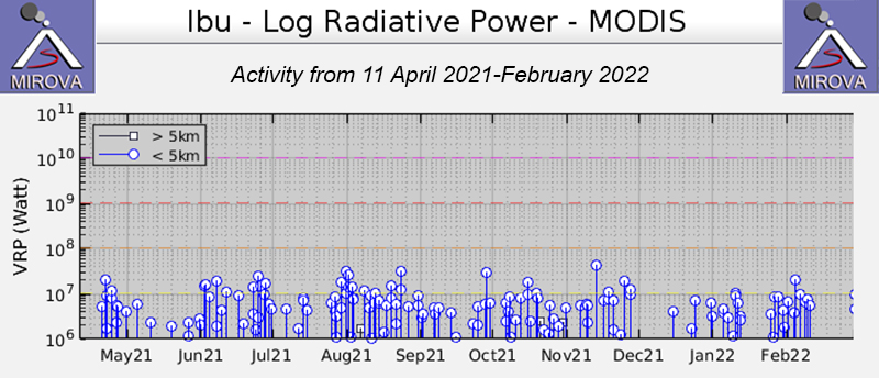 |
Figure 36. Persistent low- to- moderate-power thermal anomalies were detected at the summit crater of Ibu during September 2021 through mid-February 2022, though a short break in activity occurred during late November to mid-December 2021, as shown by the MIROVA graph (Log Radiative Power). Courtesy of MIROVA. |
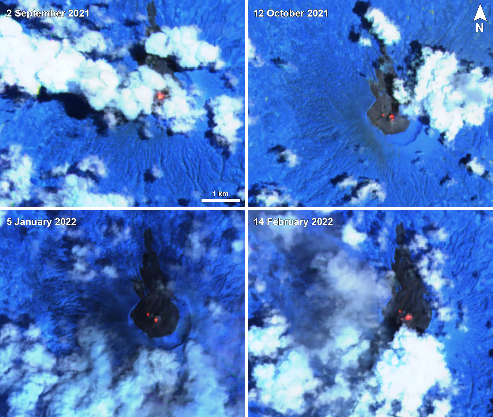 |
Figure 37. Thermal anomalies of varying intensity were visible in the summit crater of Ibu on 2 September 2021 (top left), 12 October 2021 (top right), 5 January 2022 (bottom left), and 14 February 2022 (bottom right). Two anomalies, one in the summit crater and a smaller one to the NW of it, appeared on 12 October, 5 January, and 14 February. Images using “Atmospheric penetration” (bands 12, 11, 8A) rendering. Courtesy of Sentinel Hub Playground. |
Intermittent ash plumes were reported during September 2021 while white-and-gray emissions rose 200-800 m above the summit each day. Daily eruption events ranged from 55-102, the higher number occurring on 8 September, according to PVMBG daily reports. On 6 September an ash plume rose 400 m above the summit at 0916 and drifted N. Another ash plume on 18 September rose 1 km above the summit at 1135 and drifted W (figure 38). Two avalanches were reported on 30 September traveling 1 km to the W.
 |
Figure 38. Images of various ash plumes rising above Ibu on 18 September (top left), 11 November (top right), 18 December (bottom left) 2021, and 16 February (bottom right) 2022 and drifting in different directions. The ash plume on 18 September rose 1 km above the summit and drifted W. The ash plume on 16 February rose to 2.1 km altitude and drifted S. Courtesy of MAGMA Indonesia. |
White-and-gray emissions persisted every day during October, rising 200-800 m above the summit. Daily eruption events ranged from 0-81, the most of which occurred on 28 October. Some light ashfall was reported in the towns to the W of the volcano on 1 October. On 7 and 19 October an explosion generated an ash plume that rose 800 m above the summit. According to a VONA issued on 9 October, an ash plume rose to 1.7 km altitude at 1651 and drifted NE. Another VONA published on 16 October described an ash plume that rose 600 m above the summit at 0838 and drifted N. On 31 October, an ash plume rose 500 m above the summit at 0818.
Similar low activity continued in November; white-and-gray emissions rose 200-800 m above the summit and intermittent ash plumes rose as high as 2.3 km altitude. Daily eruption events ranged from 1-87, the most of which occurred on 26 November. On 6 November an ash plume rose to 2.3 km altitude at 0637 and drifted W and S. Two days later, on 8 November, an ash plume rose 1 km above the summit at 0957 and drifted S. During 10-11 November, ash plumes drifted W, causing some light ashfall in communities to the W of the volcano. VONAs issued on 16 and 19 November described ash plumes rising 1-8-2.3 km altitude that drifted N and S.
During December, the primary form of activity was white-and-gray emissions rising 200-1,000 m above the summit. Daily eruption events ranged from 56-87, the most of which occurred on 18 December. On 20 December, an avalanche traveled 100-400 m to the NW.
Low activity during January 2022 consisted of daily white-and-gray emissions that rose 200-1,000 m above the summit. During 1-4 January, avalanches were detected each day, but they were not visually observed. Daily eruption events ranged from 66-94, the most of which occurred on 17 January. During 8-9 January, strong rumbling sounds were heard and minor ashfall was reported to the W of the volcano.
During February, white-and-gray emissions persisted, rising 200-1,000 m above the summit, while intermittent ash plumes rose to 2.3 km altitude. Daily eruption events ranged from 46-82, the most of which occurred on 2 and 4 February. Ash plumes were reported on 14, 16, 18, and 23 February, according to VONA notices, rising to 2.1-2.3 km altitude and drifting W, S, and SW (figure 38).
Geological Summary. The truncated summit of Gunung Ibu stratovolcano along the NW coast of Halmahera Island has large nested summit craters. The inner crater, 1 km wide and 400 m deep, has contained several small crater lakes. The 1.2-km-wide outer crater is breached on the N, creating a steep-walled valley. A large cone grew ENE of the summit, and a smaller one to the WSW has fed a lava flow down the W flank. A group of maars is located below the N and W flanks. The first observed and recorded eruption was a small explosion from the summit crater in 1911. Eruptive activity began again in December 1998, producing a lava dome that eventually covered much of the floor of the inner summit crater along with ongoing explosive ash emissions.
Information Contacts: Pusat Vulkanologi dan Mitigasi Bencana Geologi (PVMBG, also known as Indonesian Center for Volcanology and Geological Hazard Mitigation, CVGHM), Jalan Diponegoro 57, Bandung 40122, Indonesia (URL: http://www.vsi.esdm.go.id/); MAGMA Indonesia, Kementerian Energi dan Sumber Daya Mineral (URL: https://magma.esdm.go.id/v1); Darwin Volcanic Ash Advisory Centre (VAAC), Bureau of Meteorology, Northern Territory Regional Office, PO Box 40050, Casuarina, NT 0811, Australia (URL: http://www.bom.gov.au/info/vaac/); MIROVA (Middle InfraRed Observation of Volcanic Activity), a collaborative project between the Universities of Turin and Florence (Italy) supported by the Centre for Volcanic Risk of the Italian Civil Protection Department (URL: http://www.mirovaweb.it/); Hawai'i Institute of Geophysics and Planetology (HIGP) - MODVOLC Thermal Alerts System, School of Ocean and Earth Science and Technology (SOEST), Univ. of Hawai'i, 2525 Correa Road, Honolulu, HI 96822, USA (URL: http://modis.higp.hawaii.edu/); Sentinel Hub Playground (URL: https://www.sentinel-hub.com/explore/sentinel-playground).