Report on Villarrica (Chile) — April 2022

Bulletin of the Global Volcanism Network, vol. 47, no. 4 (April 2022)
Managing Editor: Benjamin Andrews.
Edited by Kadie L. Bennis.
Villarrica (Chile) Gas-and-steam emissions, seismicity, and crater incandescence during September 2021-February 2022
Please cite this report as:
Global Volcanism Program, 2022. Report on Villarrica (Chile) (Bennis, K.L., and Andrews, B., eds.). Bulletin of the Global Volcanism Network, 47:4. Smithsonian Institution. https://doi.org/10.5479/si.GVP.BGVN202204-357120
Villarrica
Chile
39.42°S, 71.93°W; summit elev. 2847 m
All times are local (unless otherwise noted)
Villarrica has had documented eruptions dating back to 1558, which have consisted largely of mild-to-moderate explosive activity and occasional lava effusions. Its currently active cone has a 2-km-wide caldera at its base. The current eruption period has been ongoing since December 2014 and more recently has been characterized by low-level activity of thermal anomalies, gas-and-steam emissions, and sulfur dioxide emissions. This reporting period of September 2021 through February 2022 continues this pattern of low-level activity. Information for this report primarily comes from the Southern Andes Volcano Observatory (Observatorio Volcanológico de Los Andes del Sur, OVDAS), part of Chile's National Service of Geology and Mining (Servicio Nacional de Geología y Minería, SERNAGEOMIN) and satellite data.
Seismicity and thermal activity were relatively low in September. Continuous tremor, as many as 162 long period (LP), and 4 volcano-tectonic (VT) seismic events were recorded. Gas-and-steam emissions rose less than 500 m above the crater rim. A single thermal anomaly was visible above the volcano on 20 September, according to MIROVA data, and three anomalies were detected in Sentinel-2L2A satellite imagery on 7, 10, and 20 September (figure 116).
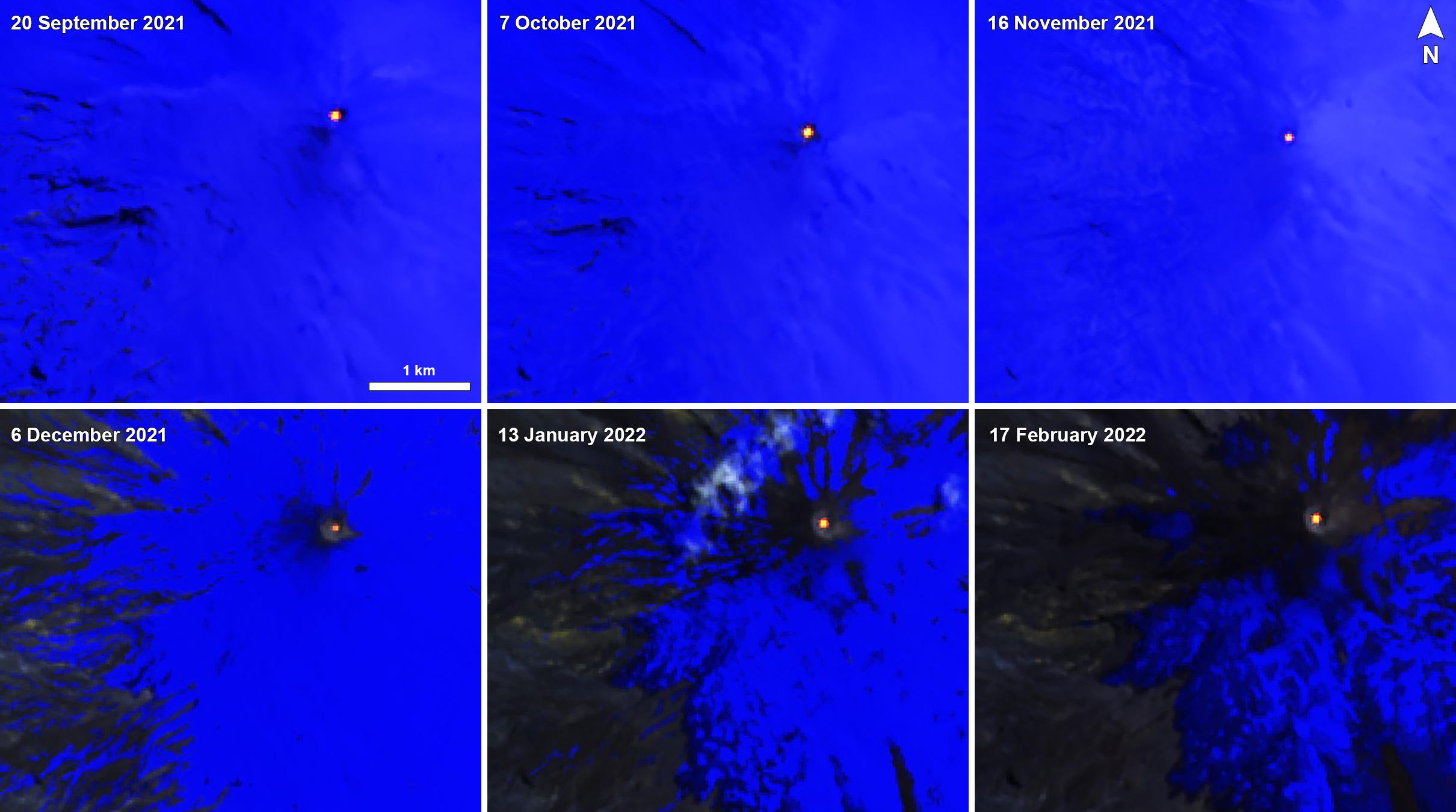 |
Figure 116. Intermittent thermal anomalies of varying intensity were visible in Sentinel-2 infrared satellite images of Villarrica during September 2021 through February 2022 on clear weather days. Images use Atmospheric penetration rendering (bands 12, 11, 8a). Courtesy of Sentinel Hub Playground. |
The number of LP-type events increased during October; as many as 2,142 were detected, in addition to 5 VT-type events. White gas-and-steam emissions of varying intensities throughout the month rose 1 km above the crater rim. MIROVA reported only one thermal anomaly, on 26 October, and Sentinel-2L2A imagery showed six anomalies on 7, 10, 12, 17, 27, and 30 October, according to SERNAGEOMIN (figure 116).
LP, tremor (TR), and VT-type seismic events were detected during November; about 504 LP and 88 VT-type earthquakes were recorded. The highest magnitude earthquake was 3.4, detected on 28 November about 10.8 km ESE of the crater. Throughout the month, gas-and-steam emissions rose less than 500 m above the crater rim. According to a notice from the Buenos Aires VAAC, an ash plume rose to 3.4 km altitude and drifted SE on 6 November. Analysis of Sentinel-2L2A satellite images showed nine thermal anomalies that occurred on 1, 6, 11, 16,19, 21, 24, 26, and 29 November (figure 116).
The number of LP earthquakes increased during December. About 2,888 LP earthquakes were recorded over the month, in addition to as many as 614 TR-type events. Gas-and-steam emissions persisted, rising less than 500 m above the crater rim. According to data from Sentinel-2L2A satellite imagery, ten thermal anomalies were visible in the crater on 4, 9, 14, 16, 19, 21, 24, 26, 29, and 31 December. SERNAGEOMIN used equipment for Differential Absorption Optical Spectroscopy (DOAS) to measure an average sulfur dioxide value of 412 and 608 t/d on 28 and 30 December, respectively.
During January 2022, LP and TR-type seismicity persisted, the latter of which presented an energy value (RSAM) between 0.1 and 0.4 units. About 3,766 earthquakes were detected, most of which were LP type, 53 were TR-type events, and five were VT-type events. Consistent gas-and-steam emissions rose to a maximum height of 540 m on 6 January. Based on DOAS measurements of sulfur dioxide emissions, an average value of 595 t/d was recorded, with a daily maximum value of 1,763 t/d on 19 January. Sentinel-2L2A satellite images showed a total of 8 thermal hotspots within the crater on 5, 8, 10, 13, 15, 25, 28, and 30 January (figure 116).
Seismicity in February was considered low, with the RSAM units measuring between 0.2 and 0.5. About 2,811 LP-type, 4 TR-type, and 1 VT-type seismic events were detected. The average value of sulfur dioxide emissions was 451 t/d, with a daily maximum value of 774 t/d on 15 February. On 2 February an ash plume rose to 2.7-4.6 km altitude and drifted E at 1050, based on data from two webcam images and information from SERNAGEOMIN. By 1130 the plume was barely visible in satellite images. Webcam images showed continuous gas-and-steam emissions with sporadic puffs of ash rising as high as 4.9 km altitude, although by 2330, the ash was no longer visible. There were seven thermal anomalies detected during the month on 2, 4, 7, 9, 12, 14, and 17 February (figure 116). Low-intensity incandescence was visible from 12 to 15 February. Gas-and-steam emissions persisted, with a maximum height of 520 m above the crater rim on 21 February.
Geological Summary. The glacier-covered Villarrica stratovolcano, in the northern Lakes District of central Chile, is ~15 km south of the city of Pucon. A 2-km-wide caldera that formed about 3,500 years ago is located at the base of the presently active, dominantly basaltic to basaltic andesite cone at the NW margin of a 6-km-wide Pleistocene caldera. More than 30 scoria cones and fissure vents are present on the flanks. Plinian eruptions and pyroclastic flows that have extended up to 20 km from the volcano were produced during the Holocene. Lava flows up to 18 km long have issued from summit and flank vents. Eruptions documented since 1558 CE have consisted largely of mild-to-moderate explosive activity with occasional lava effusion. Glaciers cover 40 km2 of the volcano, and lahars have damaged towns on its flanks.
Information Contacts: Servicio Nacional de Geología y Minería (SERNAGEOMIN), Observatorio Volcanológico de Los Andes del Sur (OVDAS), Avda Sta María No. 0104, Santiago, Chile (URL: http://www.sernageomin.cl/); Buenos Aires Volcanic Ash Advisory Center (VAAC), Servicio Meteorológico Nacional-Fuerza Aérea Argentina, 25 de mayo 658, Buenos Aires, Argentina (URL: http://www.smn.gov.ar/vaac/buenosaires/inicio.php); MIROVA (Middle InfraRed Observation of Volcanic Activity), a collaborative project between the Universities of Turin and Florence (Italy) supported by the Centre for Volcanic Risk of the Italian Civil Protection Department (URL: http://www.mirovaweb.it/); Sentinel Hub Playground (URL: https://www.sentinel-hub.com/explore/sentinel-playground).