Report on Krakatau (Indonesia) — May 2022

Bulletin of the Global Volcanism Network, vol. 47, no. 5 (May 2022)
Managing Editor: Edward Venzke.
Edited by A. Elizabeth Crafford.
Krakatau (Indonesia) Explosive events during February-April 2022; new lava flow on 23 April
Please cite this report as:
Global Volcanism Program, 2022. Report on Krakatau (Indonesia) (Crafford, A.E., and Venzke, E., eds.). Bulletin of the Global Volcanism Network, 47:5. Smithsonian Institution. https://doi.org/10.5479/si.GVP.BGVN202205-262000
Krakatau
Indonesia
6.1009°S, 105.4233°E; summit elev. 285 m
All times are local (unless otherwise noted)
Krakatau volcano in the Sunda Strait between Java and Sumatra, Indonesia, had a major caldera collapse around 535 CE; this event formed a 7-km-wide caldera ringed by the three islands of Verlaten, Lang, and Rakata. A new island grew that was then destroyed in the 1883 caldera-forming eruption. Anak Krakatau (Child of Krakatau), constructed beginning in late 1927 (BGVN 44:03, figure 56), was the site of over 40 smaller eruptions until 22 December 2018 when a large explosion destroyed most of the 338-m-high edifice and generated a deadly tsunami (BGVN 44:03). Intermittent ash-bearing explosions from the sea-level crater since May 2021 have contributed to the growth of a new pyroclastic cone to about 150 m elevation. Activity from December 2021 to April 2022, including a new lava flow in April 2022, is covered in this report with information provided by the Indonesian Center for Volcanology and Geological Hazard Mitigation, referred to as Pusat Vulkanologi dan Mitigasi Bencana Geologi (PVMBG), the Darwin Volcanic Ash Advisory Center (VAAC), and several sources of satellite data. Additional information not previously reported of eruptive activity during 2011 and 2013 is also provided.
Anak Krakatau was quiet from 7 November 2021 until a series of explosions during 3-6 February 2022. Steam and ash plumes rose 2 km above the summit and drifted in multiple directions. Multiple explosions during 24-30 March 2022 produced plumes of dense gray and black ash that also rose 2 km above the summit. Renewed explosions during 15-23 April 2022 rose 500-2,000 m above the summit and drifted in multiple directions. Activity increased significantly on 23 April, causing PVMBG to raise the Alert Level from II to III. A lava flow emerged from the summit onto the W flank and reached the sea. Continuous ash emissions rose to 6 km altitude until 25 April when activity tapered off before ceasing by 27 April 2022 (figure 119). Thermal activity remained low throughout the period until increased explosive and effusive activity began in late April (figure 120).
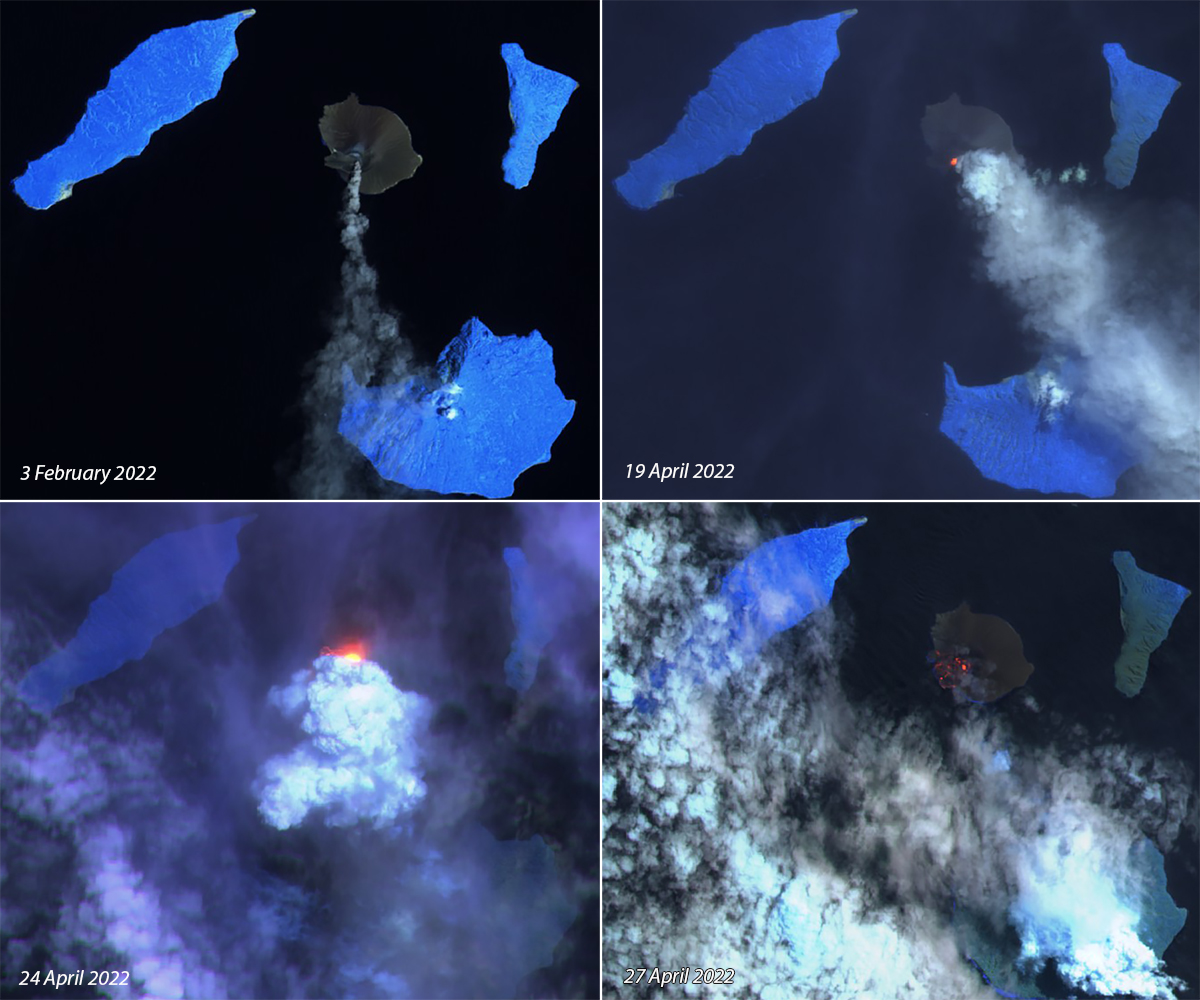 |
Figure 119. Explosions resumed at Krakatau after three months of quiet on 3 February 2022 (top left) with steam and ash plumes that rose 2 km above the summit and drifted S. A series of explosions that began on 15 April produced ash and steam on 19 April (top right) that drifted SE. Activity intensified on 23 April and a lava flow emerged and traveled down the SW flank of the cone, producing a strong thermal anomaly and dense steam emissions on 24 April (bottom left). Remnants of the cooling flow were still visible as thermal anomalies on the SW flank on 27 April 2022 (bottom right). Courtesy of Sentinel Hub Playground. |
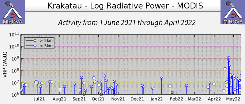 |
Figure 120. Thermal activity remained low at Anak Krakatau until late April 2022 when explosions and a lava flow caused a spike in the thermal signature recorded in the MIROVA project graph of log radiative power from 1 June 2021 through April 2022. Courtesy of MIROVA. |
Activity during December 2021-April 2022. Anak Krakatau was quiet during December 2021 and January 2022, with only diffuse steam plumes 25-100 m high reported on many days. Low levels of seismicity consisted of continuous tremor, harmonic tremor, and seismicity from fumarolic degassing on most days, with infrequent deeper low-magnitude earthquakes.
A VONA issued by the Anak Krakatau Volcano Observatory on 3 February 2022 indicated that gray ash emissions rose 200 m above the summit and drifted NE. The first explosion recorded in the early morning the following day produced a dense white and gray plume that rose 500 m above the summit and drifted SW; subsequent explosions produced plumes of dense, black ash that rose 600-1,000 m above the summit and drifted S and E (figure 121). Overnight on 4-5 February ash plumes rose to altitudes of 400-1,600 m. By midday local time on 5 February the plumes were rising 2,000 m above the summit and drifting slowly SE. Multiple explosions on 6 February sent ash plumes to 750-1,650 m altitude that drifted E before activity ceased by the end of the day. Multiple earthquakes from the explosions were recorded each day on 5 and 6 February. For the remainder of the month, white steam plumes rose 25-100 m and no further explosive activity was reported.
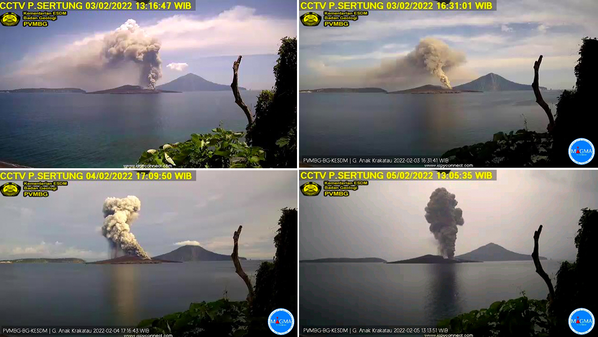 |
Figure 121. An eruption at Anak Krakatau during 3-6 February 2022 initially produced white and gray emissions that became dense black ash emissions to as high as 2 km above the summit (2,150 m altitude). Courtesy of MAGMA Indonesia. |
Steam plumes rose 25-100 m above the crater during 1-23 March 2022. The background seismicity included continuous tremor, shallow and deep earthquakes, and multiple earthquakes from steam and gas venting on most days. A new series of explosions that began on 24 March produced white and gray steam and ash emissions that rose 25-1,000 m above the summit that day. Four eruption earthquakes were recorded. Multiple gray and black ash plumes also rose 1,000-2,000 m above the summit on 25 March and drifted E (figure 122), and 19 eruption earthquakes were recorded. Activity diminished on 26 and 27 March with gray plumes rising 400-600 m above the summit and drifting SE and NE; one eruption earthquake occurred on 26 March and two on 27 March. Gray and black ash emissions rose 1,000 m above the summit on 28 March and drifted E (figure 123). On 29 and 30 March gray and black ash emissions rose 500-700 m above the summit and drifted E and NE. One eruption earthquake was recorded on 28 March, three on 29 March, and four on the 30th.
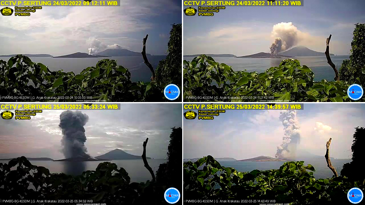 |
Figure 122. Explosions at Anak Krakatau on 24 and 25 March 2022 produced gray and black ash plumes that rose as high as 2,000 m above the summit. Courtesy of MAGMA Indonesia. |
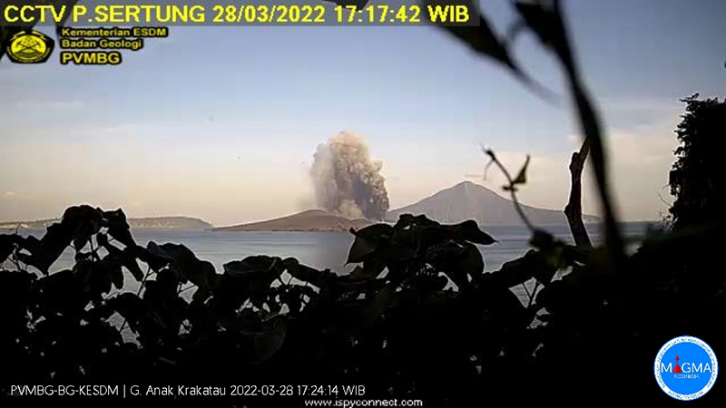 |
Figure 123. Explosions continued at Anak Krakatau during 26-30 March 2022 with gray and black ash plumes reaching 1,000 m above the summit and drifting in multiple directions, shown here on 28 March. Courtesy of MAGMA Indonesia. |
Explosions began again early on 15 April 2022 local time; three eruption earthquakes were recorded, and a white and black ash plume was reported at 1,000 m above the summit drifting SW, followed by plumes that rose 700-800 m above the 150-m-high peak (figure 124). Two eruption earthquakes on 17 April were recorded along with Strombolian activity. Multiple VONA’s were issued for dense gray and black ash plumes that rose 800 m and drifted SW. The Darwin VAAC reported continuous ash emissions drifting SW at 1.2-2 km altitude. Seven eruption earthquakes were recorded on 18 April. Three dense black ash plumes rose 700 m above the summit and drifted SW during the first half of the day (figure 124). This was followed in the afternoon by two larger gray and black plumes that rose 2,000 and 1,000 m above the summit. Continuous gray emissions rose 50-500 m during 19-21 April; the gray and black ash plume rose 800 m above the summit and drifted E.
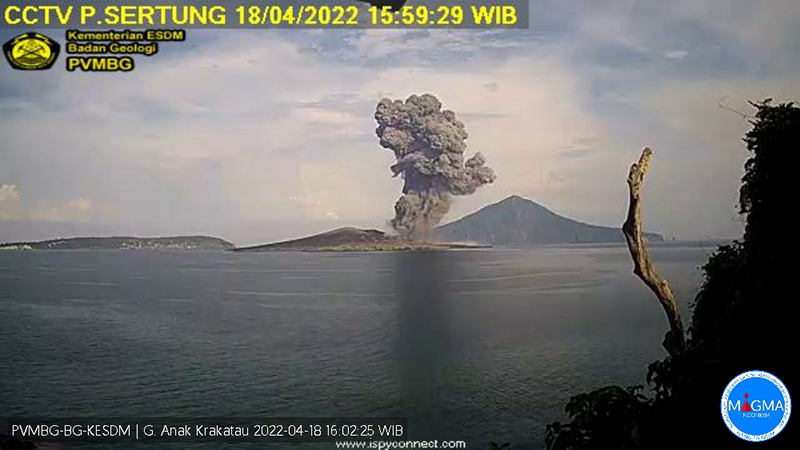 |
Figure 124. During 15-18 April 2022 multiple gray and black ash plumes rose up to 1,000 m above the summit of Anak Krakatau and drifted mostly SW including this one on 18 April. Courtesy of MAGMA Indonesia. |
Multiple explosions were observed on 22 April; dense, black ash plumes rose 500-1,500 m above the summit and drifted SW, rumbling sounds from the explosions were heard at the Observatory, and eight eruption earthquakes were recorded that day. Continuous high-amplitude tremor on 23 April accompanied ash emissions that rose 300-3,000 m above the summit and drifted SE and S. In a VONA released by the Observatory at 1434 local time they noted a lava flow on the W side of the crater that remained active the next day (figure 125). The Darwin VAAC reported continuous localized ash emissions to 4.6 km altitude extending SE, and plumes to 6.1 km later in the day. Explosions could be heard at the Pasauran PGA post on 24 April and they reported dense gray and black ash emissions rising to 3 km altitude, and drifting SE and S.
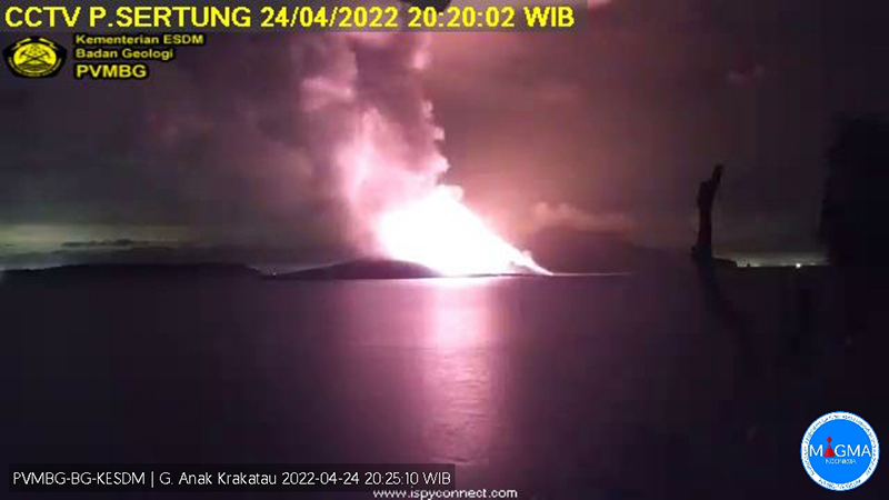 |
Figure 125. Bright incandescence from Anak Krakatau on 24 April 2022 was from a lava flow on the W flank, which produced steam as it entered the ocean. Courtesy of MAGMA Indonesia. |
The sharp increases in seismic amplitude, eruption intensity, inflation and deflation patterns, and SO2 emissions beginning on 23 April (figure 126) led PVMBG to raise the Alert Level from II to III the next day. The Darwin VAAC reported continuous ash emissions extending SW at 6.1 km altitude until early on 25 April when they dropped to 3 km altitude and drifted NE. Emissions were drifting E and SE at 1.5 km altitude on 26 and 27 April. During an overflight on 28 April BNPB officials observed a new lava flow on the SW flank that had emerged from the summit and entered the ocean (figure 127). Multiple MODVOLC thermal alerts were recorded during 20-29 April.
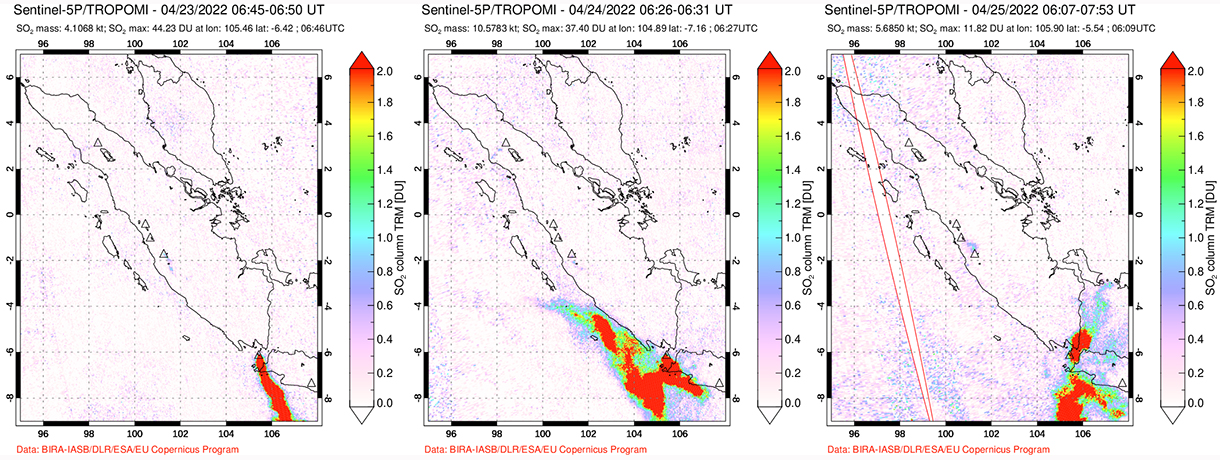 |
Figure 126. Large amounts of SO2 from Anak Krakatau were detected beginning on 23 April 2022 by the TROPOMI instrument on the Sentinel-5P satellite. Courtesy of NASA Global Sulfur Dioxide Monitoring Page. |
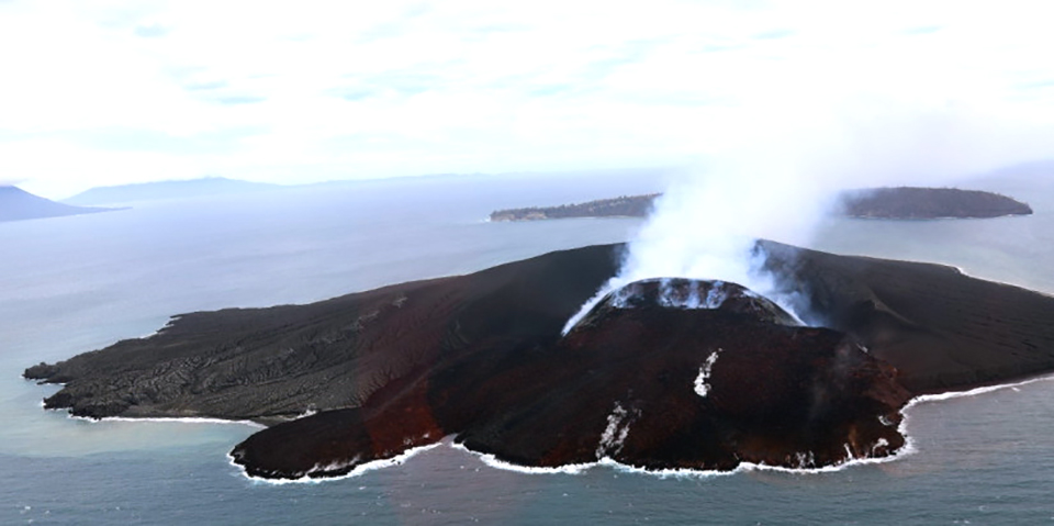 |
Figure 127. An overflight of Anak Krakatau by BNPB officials on 28 April 2022 revealed a new lava flow on the SW flank of the pyroclastic cone that had reached the ocean. Courtesy of BNPB. |
Eruptive activity during May-July 2011. An eruptive pause and decreased seismicity in March 2011 suggested that the eruption was over, though a possible weak ash plume was seen in satellite imagery on 31 July (BGVN 36:8). However, a MODVOLC thermal alert from 17 May 2011 suggested an earlier renewal of surface activity. Observations on 25 June 2011 from photographer Øystein Lund Andersen confirmed Strombolian activity, lava bombs, and lightning (figure 128), followed by another MODVOLC alert on 28 June. Multiple daily thermal alerts began on 18 July and were intermittent through the end of November 2011, and other reports of eruptive activity were more frequent during that time (BGVN 37:11 and 37:12).
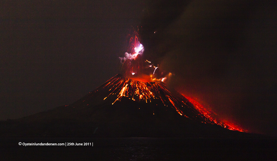 |
Figure 128. Strombolian explosions, lava bombs, and lightning at Krakatau on 25 June 2011. Copyrighted photo courtesy of Øystein Lund Andersen, used with permission. |
Eruptive activity during March and October 2013. According to Andersen, PVMBG reported an eruption on 11-12 March 2013, which they described as the first eruption since September 2012. During a visit on 23 March, Andersen found evidence of fresh eruptive activity on the E flank in the form of large clasts and fresh impacts (figure 129), observed gas emissions rising 300-400 m above the summit, and saw a small area of incandescent material near the SW corner of the crater rim. A field camera placed by Andersen on nearby Verlaten Island captured an explosion at 0856 local time on 28 March from the northern part of the crater, producing a pyroclastic flow down the N flank. A second eruption was recorded at 1716 local time, also on the N flank. A single MODVOLC thermal alert was issued that day. Photos taken of an hour-long eruption at midday on 29 March from the SSW area of the crater, a different location from the previous day (figure 130), showed a small pyroclastic flow traveling 100 m down the S flank. Incandescent gas emissions were noted during March-October 2013; the remote camera captured an ash emission on 31 October 2013, but the volcano remained quiet after that until 31 March 2014 (BGVN 40:08).
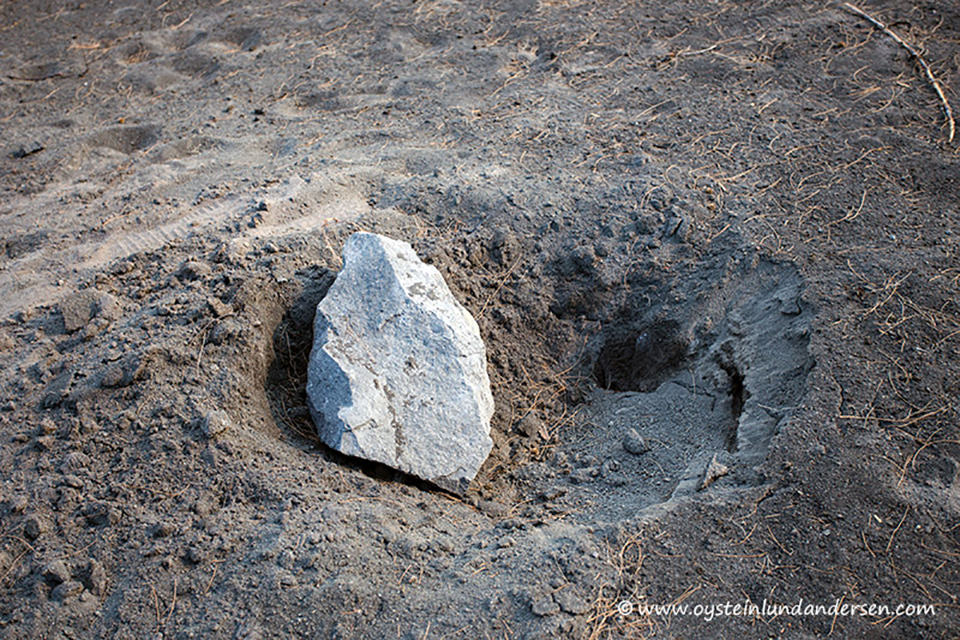 |
Figure 129. A fresh impact crater and a volcanic rock fragment at Anak Krakatau on 23 March 2011 supported the PVMBG report of an eruption on 11-12 March that damaged seismic equipment. Copyrighted image courtesy of Øystein Lund Andersen, used with permission. |
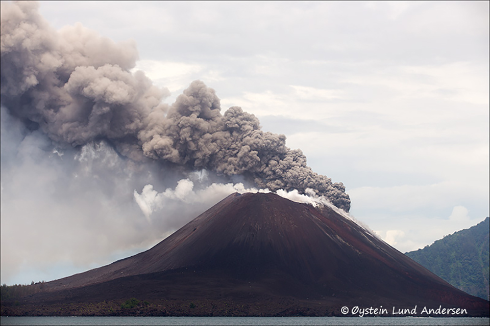 |
Figure 130. Dark gray ash emissions and white steam emerged from Krakatau during a brief eruption on 28-29 March 2013. Copyrighted image courtesy of Øystein Lund Andersen, used with permission. |
Geological Summary. The renowned Krakatau (frequently mis-named as Krakatoa) volcano lies in the Sunda Strait between Java and Sumatra. Collapse of an older edifice, perhaps in 416 or 535 CE, formed a 7-km-wide caldera. Remnants of that volcano are preserved in Verlaten and Lang Islands; subsequently the Rakata, Danan, and Perbuwatan cones were formed, coalescing to create the pre-1883 Krakatau Island. Caldera collapse during the catastrophic 1883 eruption destroyed Danan and Perbuwatan, and left only a remnant of Rakata. This eruption caused more than 36,000 fatalities, most as a result of tsunamis that swept the adjacent coastlines of Sumatra and Java. Pyroclastic surges traveled 40 km across the Sunda Strait and reached the Sumatra coast. After a quiescence of less than a half century, the post-collapse cone of Anak Krakatau (Child of Krakatau) was constructed within the 1883 caldera at a point between the former Danan and Perbuwatan cones. Anak Krakatau has been the site of frequent eruptions since 1927.
Information Contacts: Pusat Vulkanologi dan Mitigasi Bencana Geologi (PVMBG, also known as Indonesian Center for Volcanology and Geological Hazard Mitigation, CVGHM), Jalan Diponegoro 57, Bandung 40122, Indonesia (URL: http://www.vsi.esdm.go.id/); MAGMA Indonesia, Kementerian Energi dan Sumber Daya Mineral (URL: https://magma.esdm.go.id/v1); Badan Nasional Penanggulangan Bencana (BNPB), National Disaster Management Agency, Graha BNPB - Jl. Scout Kav.38, East Jakarta 13120, Indonesia (URL: https://www.bnpb.go.id/berita/tinjau-gunung-anak-krakatau-kepala-bnpb-imbau-masyarakat-tingkatkan-kesiapsiagaan); Darwin Volcanic Ash Advisory Centre (VAAC), Bureau of Meteorology, Northern Territory Regional Office, PO Box 40050, Casuarina, NT 0811, Australia (URL: http://www.bom.gov.au/info/vaac/); NASA Global Sulfur Dioxide Monitoring Page, Atmospheric Chemistry and Dynamics Laboratory, NASA Goddard Space Flight Center (NASA/GSFC), 8800 Greenbelt Road, Goddard MD 20771, USA (URL: https://so2.gsfc.nasa.gov/); Sentinel Hub Playground (URL: https://www.sentinel-hub.com/explore/sentinel-playground); Øystein Lund Andersen? (URL: https://www.oysteinlundandersen.com/, https://twitter.com/oysteinvolcano); MIROVA (Middle InfraRed Observation of Volcanic Activity), a collaborative project between the Universities of Turin and Florence (Italy) supported by the Centre for Volcanic Risk of the Italian Civil Protection Department (URL: http://www.mirovaweb.it/); Hawai'i Institute of Geophysics and Planetology (HIGP) - MODVOLC Thermal Alerts System, School of Ocean and Earth Science and Technology (SOEST), Univ. of Hawai'i, 2525 Correa Road, Honolulu, HI 96822, USA (URL: http://modis.higp.hawaii.edu/).