Report on Fagradalsfjall (Iceland) — September 2022

Bulletin of the Global Volcanism Network, vol. 47, no. 9 (September 2022)
Managing Editor: Edward Venzke.
Edited by Kadie L. Bennis.
Fagradalsfjall (Iceland) New eruption during August 2022 consisted of lava fountains and flows
Please cite this report as:
Global Volcanism Program, 2022. Report on Fagradalsfjall (Iceland) (Bennis, K.L., and Venzke, E., eds.). Bulletin of the Global Volcanism Network, 47:9. Smithsonian Institution.
Fagradalsfjall
Iceland
63.895°N, 22.258°W; summit elev. 250 m
All times are local (unless otherwise noted)
The Fagradalsfjall volcanic system on the Reykjanes Volcanic Zone in Iceland erupted on 19 March 2021, following more than a year of earthquake activity and inflation/deflation periods. This was the first volcanic activity on the system after about 6,000 years of quiescence. Although the Fagradalsfjall fissure swarm has previously been considered a split or secondary swarm of the Krýsuvík-Trölladyngja volcanic system, as of September 2022 Icelandic volcanologists managing the Catalogue of Icelandic Volcanoes made the decision to identify Fagradalsfjall as a distinct and separate system.
The fissure eruption that started in March 2021 in the Geldingadalur (also referred to as Geldingadalir) valley continued until mid-September 2021 (BGVN 46:05; 46:10). Several fissure vents opened along a NE-SW trend, accompanied by gas-and-steam emissions, spatter, and lava fountains; flows began to fill Geldingadalur and eventually reached the Meradalir valley. This report covers a new eruption period that began on 3 August 2022 using information from the Icelandic Meteorological Office (IMO), the Institute of Earth Sciences, and various satellite data.
Activity during October 2021-29 July 2022. The Institute of Earth Sciences reported that lava effusion had stopped during the evening of 18 September 2021. The area of the flow field was about 4.85 km2, and the total volume erupted was 150 million cubic meters, based on 30 September measurements. Nighttime incandescence was visible through 4 October, likely from lava flows that continued to advance downslope. According to news reports, over 6,000 earthquakes at depths of 5-6 km were recorded by 4 October, the largest event of which was an Mw 3.8. The seismic swarm had significantly decreased by mid-October and on 18 October the ACC was lowered to Yellow (the second lowest level on a four-color scale). IMO also reported that gas emissions were ongoing, though with low concentrations of eruptive gases. Incandescence from previously emplaced lava flows were occasionally visible at night.
Seismicity increased at 1800 on 21 December 2021 in an area 2-4 km NE of Geldingadalur, which consisted of 18 events. Then, activity markedly intensified at 00300 on 22 December; there were 1-10 tremors recorded per minute, totaling to more than 1,400 events by 1047, the largest of which was an Mw 4.9 at 0923. This seismic swarm continued through 28 December, consisting of more than 19,000 earthquakes; about 14 earthquakes were at an Mw 4 or higher. During 29 December 2021 to 3 January 2022, the number and size of these events had progressively decreased; more than 200 events detected during 0000-1535 on 3 January. By 7 January, the seismic events had stopped.
Activity from 30 July 2022-2 August 2022. IMO reported an intense earthquake swarm that began around noon on 30 July in an area just NE of the lava field in Geldingadalur, along the dike intrusion that preceded the March-September 2021 eruption. Earthquakes were reportedly felt in SW Iceland, in Reykjanesbær, Grindavík, the Capital region, and as far as Borgarnes. Several of these earthquakes were above an Mw 3, with the largest event of an Mw 4 occurring at 1403. Almost 3,000 earthquakes had been detected by 1527 on 31 July, according to the Norwegian Meteorological Agency’s automatic location system; an Mw 5.4 event was detected at 1748. Deformation models indicated magma was around 1 km below the surface at 1749 on 2 August, according to IMO.
Activity during 3-21 August 2022. An effusive fissure eruption began around 1315 on 3 August near the border of the previous lava flow field N of Fagradalsfjall in Meradalir. IMO scientists, in conjunction with the Coast Guard, took photos of the activity during a surveillance flight and made measurements of the fissure that appeared at the northern edge of the lava field from the last eruption; initial measurements showed that the fissure was about 300 m long (figures 27 and 28). Webcam video showed lava fountains rising along the fissure, causing IMO to increase the ACC to Orange at 1536. Gas-and-steam plumes rose 500-1,000 m high, but no ash was detected. Lava flows were reported traveling downslope to the NW. The flow rate was about 32 m3/s during the initial hours of the eruption, which then decreased to an average of 18 m3/s from 1700 on 3 August until 1100 on 4 August. By this time, about 1.6 million cubic meters of lava had covered an area of 0.14 km2. The average flow thickness was around 11 m. During 3 August through the morning of 4 August, about 400 earthquakes were recorded, though these were smaller in both number and size compared to the events before the eruption began. On 5 August IMO reported that the number of daily earthquakes had declined after the eruption began; on 2 August about 2,700 earthquakes were recorded, on 4 August there were a total of 900 earthquakes, and on 5 August about 300 were detected up until 1300.
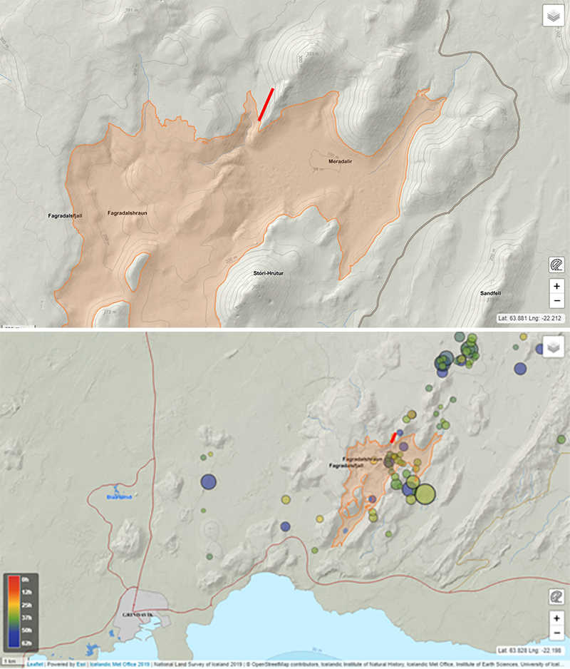 |
Figure 27. Location maps showing the approximate location of the new fissure (red line) that emerged at Fagradalsfjall (top), based on initial images taken during the overflight on 3 August 2022. The fissure is located on the northern edge of the lava that erupted during the previous eruption in March 2021 (pink colored area). The circles indicate seismic events and their location in relation to the fissure (bottom). Courtesy of IMO. |
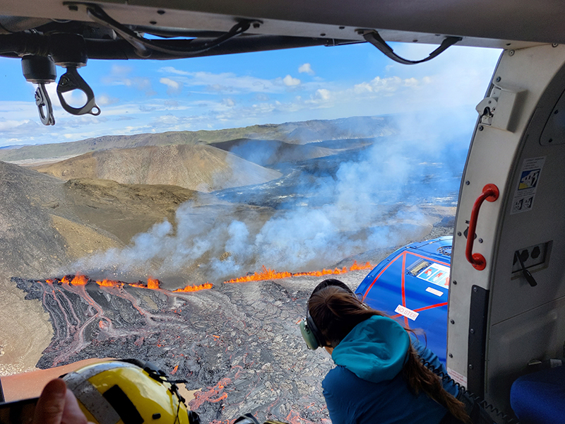 |
Figure 28. Photo showing lava fountains along with gas-and-steam emissions from the Fagradalsfjall fissure eruption on 3 August 2022. The fissure opened on the western side of Meradalir and on the northern edge of the lava flows that erupted during the previous eruption in March 2021. Courtesy of Halldór Björnsson, IMO. |
According to a news article from RUV, the length of the active fissure had decreased and the middle part of the fissure was the most active by 5 August. In addition, the number of daily earthquakes declined around the same day; strong gas-and-steam emissions were still visible (figure 29). By 10 August lava was primarily erupting from a central cone and flowed ESE and NW (figure 30). IMO reported that lava was mostly flowing onto the 2021 lava flow field and was filling the eastern end of the Meradalir lava through at least 16 August. There were three vents within the building cone that were visible on 10 August: the first is the largest and most centrally located vent, the second is to the left (east) of the central vent, and the third is the smallest one located to the right (west) of the central vent (figure 31). Each of these vents erupted strong lava fountains rising tens to several tens of meters high during at least 10-13 August, then during 14-16 August the height of the lava fountains diminished. A smaller, secondary cone formed to the east of the main cone around 12 August (figure 32). These vents fed into a large lava pond that traveled NW of the breached vent and occasionally, lava breakouts would be noted along the ponded lava (figure 31). Each day during 12-16 August the primary eruptive cone continued to grow, evolving to a perched lava pond that fed the lava flows to the NW of it (figure 32).
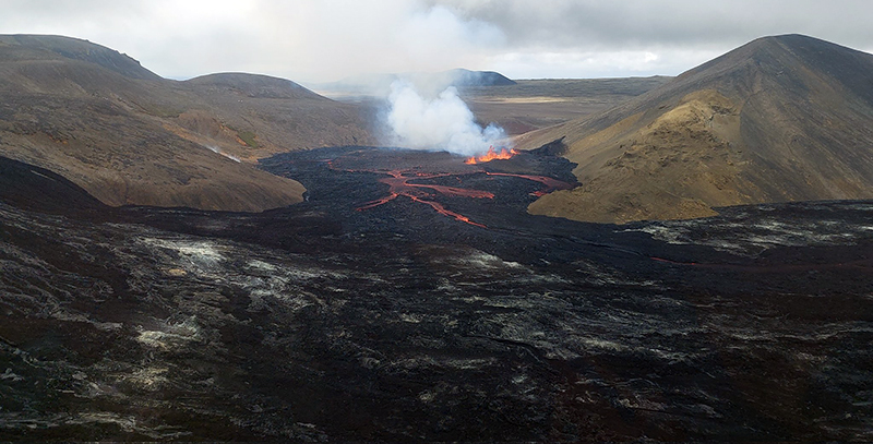 |
Figure 29. Photo showing the new fissure eruption at Fagradalsfjall on 5 August 2022 with lava fountains and lava flows moving onto the 2021 lava flow field in the Meradalir valley (older lava is black). Strong white gas-and-steam emissions accompany this activity. Courtesy of Kristín Jónsdóttir, IMO. |
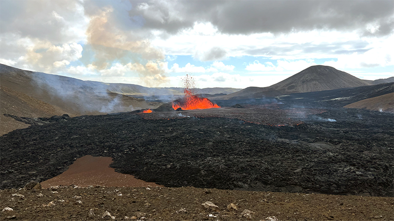 |
Figure 30. Photo showing strong lava fountains emerging from the main (larger fountain to the right) and secondary crater (smaller fountain to the left) at Fagradalsfjall on 10 August 2022. The black rocks in the foreground are the older lava flows from the 2021 eruption as new lava flows over it. Constant degassing was also visible. Courtesy of Arianna Soldati, North Carolina State University. |
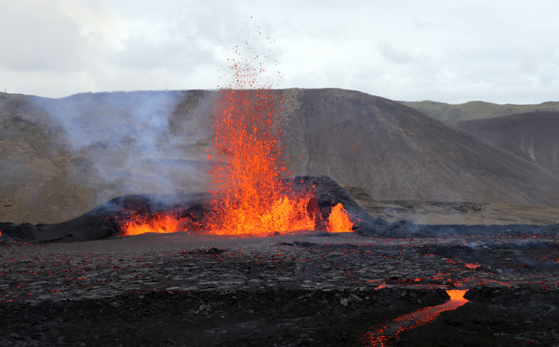 |
Figure 31. Photo showing strong lava fountains rising several tens of meters above the eruption site at Fagradalsfjall around 1200-1400 on 11 August 2022. The vent shows three distinct places where lava erupted; the first is the central one, the second is to the left, and the third is the smaller fountain to the right. The open part of the vent area faces NNW, with lava flows moving NW onto older 2021 flows. There were also several lava pond breakouts as shown in the foreground of this photo. Courtesy of Alison Graettinger, University of Missouri – Kansas City. |
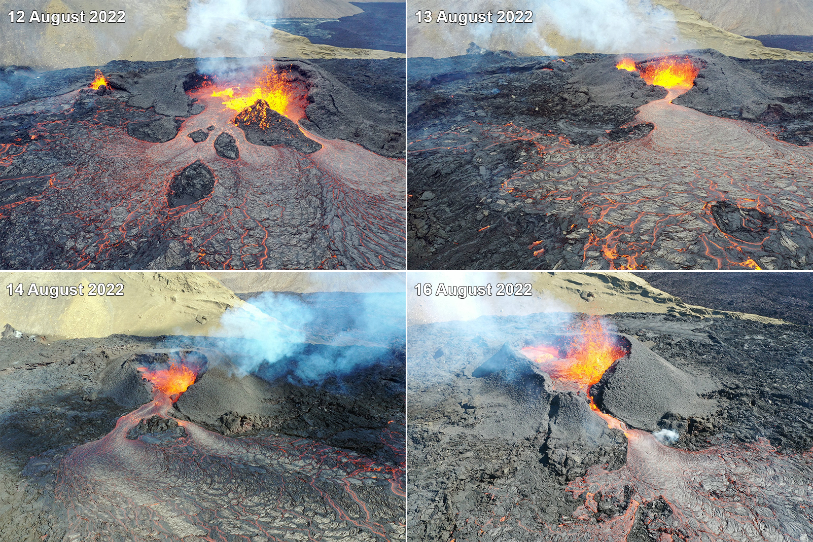 |
Figure 32. Photos showing the evolution of the primary cone at Fagradalsfjall from a breached lava pond to a perched lava pond. Lava fountains and flows persisted each day on 12th (top left), 13th (top right), 14th (bottom left), and 16th of August 2022 (bottom right). A smaller secondary cone is seen to the left (east) of the primary vent on the 12 August image. Courtesy of Brett Carr, University of Arizona. |
According to IES, the effusion rate had notably decreased from an average of 11 m3/s during 4-13 August to 3-4 m3/s during 13-15 August. By 15 August, IES estimated that 10.6 million cubic meters of lava had covered an area of 1.25 km2 (figure 33). On 16 August residents reported seeing a purple-tinged sulfur dioxide gas cloud over the eruption area slowly drifting SW during sunrise. Lava near the vent was 20-40 m thick, but flows were 5-15 m thick in the Meradalir valley, outside of the crater area. A small vent collapse on the main cone was reported sometime between 16 and 18 August, based on webcam videos. Seismic tremor began to decrease on 19 August and the level of the lava pond that had accumulated in the primary vent. There was no visible outflow from the vent. Incandescence from the northern vent and from the lava flows reflected by the gas-and-steam emissions that rose above the crater. During 20-21 August, incandescence from the vent decreased; incandescence from the vent was visible until about 0400 on 21 August. Beginning at around 0500, several explosions ejected spatter from the vent for about 15 minutes. Just before 0600 a dense, bluish-gray plume rose from the crater, and simultaneously seismic tremor signals stopped. On 22 August IMO lowered the ACC to Yellow.
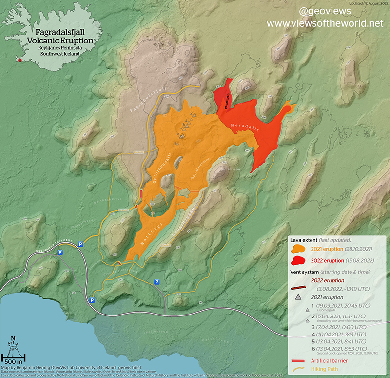 |
Figure 33. Map updated on 15 August 2022 showing the lava flow field of both recent Fagradalsfjall eruptions, including the location of the active fissure (dark red dotted line), the extent of the 2021 lava flow field (bright orange), and the extent of the 2022 lava flow field. Courtesy of Benjamin Hennig, University of Iceland. |
According to IMO, the lava from the fissure stopped erupting on 21 August. Seismicity remained at low levels and no deformation was detected. As a result, on 15 September the ACC was lowered to Green (the lowest level on a four-color scale).
Satellite data. Data from the TROPOMI instrument on the Sentinel-5P satellite, available on maps from the NASA Global Sulfur Dioxide page, showed two distinct sulfur dioxide plumes exceeding 2 DU (Dobson Units) on 4 and 14 August 2022 (figure 34). Strong thermal activity was detected MODIS data shown on MIROVA (Middle InfraRed Observation of Volcanic Activity) graphs starting at the beginning of the eruption in early August due to lava effusion (figure 35). The power of these thermal anomalies started to decline by mid-August as activity began to decrease. After the eruption stopped on 21 August 2022, some residual heat was detected through September, as seen in the MIROVA graph. Sentinel-2 infrared satellite images also showed the strong thermal activity during August, though the area was often obscured by weather clouds (figure 36). A small lava flow was visible on 15 August that flowed to the SE (figure 36).
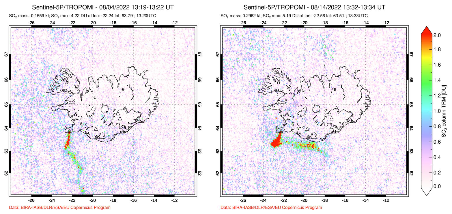 |
Figure 34. Two strong sulfur dioxide plumes that exceeded 2 DUs (Dobson Units) were detected above Fagradalsfjall on 4 August 2022 (left) and 14 August (right) and drifted SW, based on data from the TROPOMI instrument on the Sentinel-5P satellite. Courtesy of the NASA Global Sulfur Dioxide Monitoring Page. |
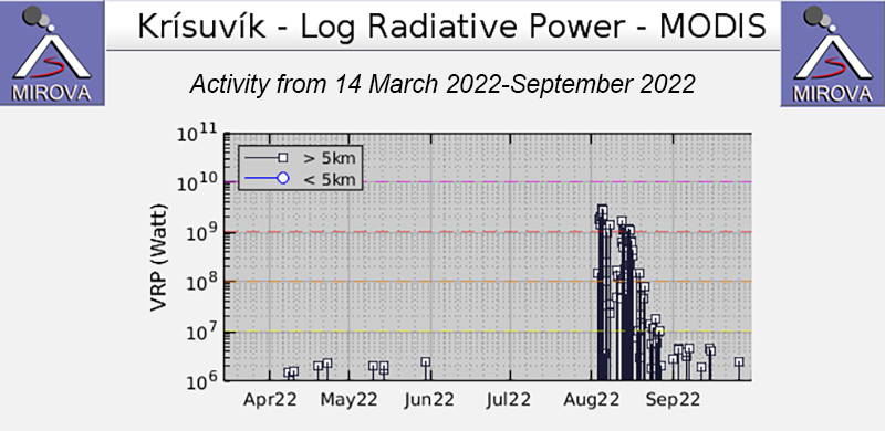 |
Figure 35. Strong thermal activity began at Fagradalsfjall in early August 2022, according to the MIROVA graph (Log Radiative Power) and continued through the month due to a new eruption that consisted of lava fountains and flows. Lower, possibly residual thermal activity remained in September. Courtesy of MIROVA. |
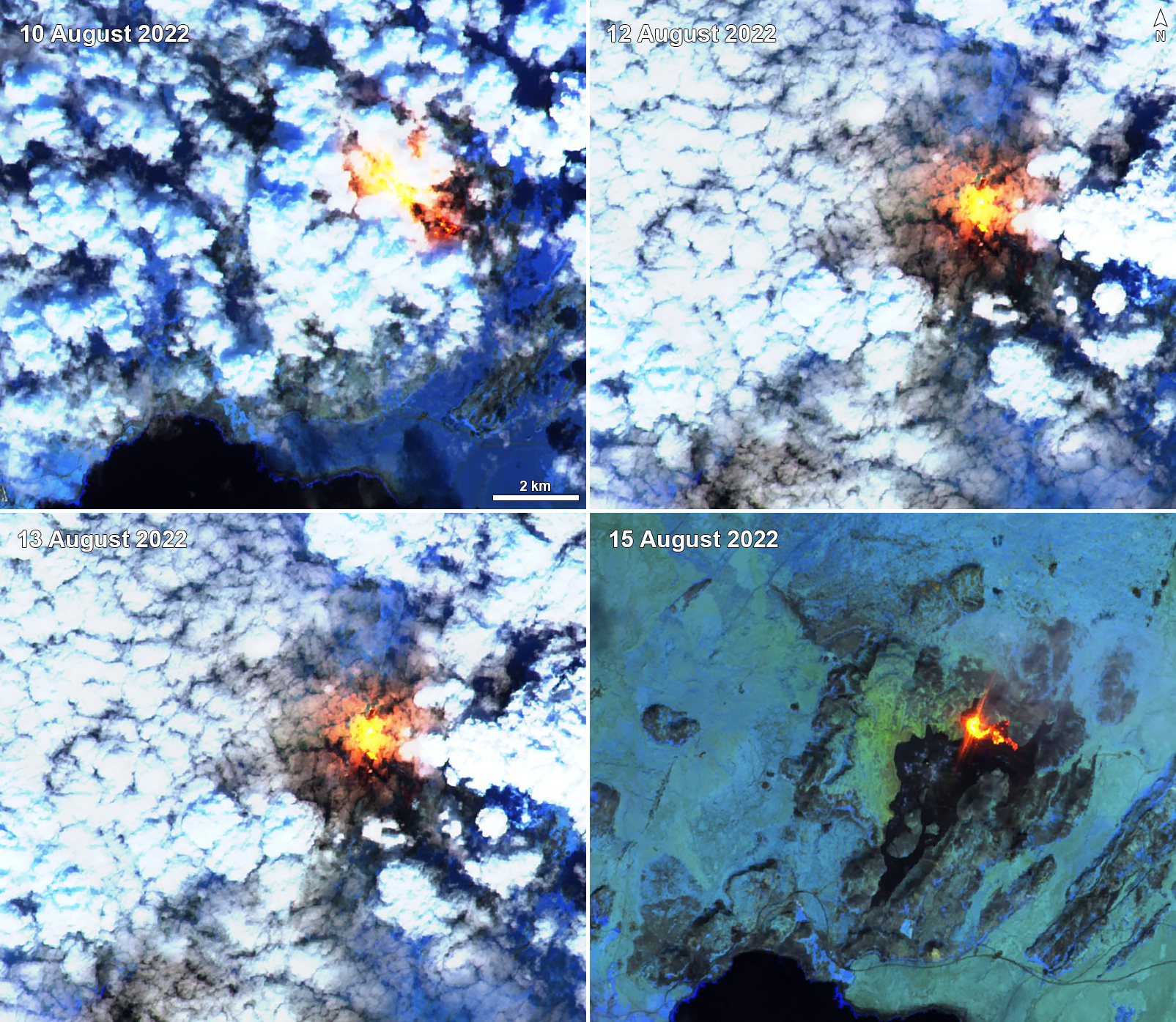 |
Figure 36. Sentinel-2 infrared satellite images show a strong thermal anomaly from Fagradalsfjall on 10 August (top left), 12 August (top right), 13 August (bottom left), and 15 August 2022 (bottom right). This thermal activity reflected the new lava flow activity during August 2022. Sentinel-2 satellite images with “Atmospheric penetration” (bands 12, 11, 8A) rendering. Courtesy of Sentinel Hub Playground. |
Geological Summary. Although the Fagradalsfjall fissure swarm has previously been considered a split or secondary swarm of the Krýsuvík–Trölladyngja volcanic system, as of September 2022 Icelandic volcanologists managing the Catalogue of Icelandic Volcanoes made the decision to identify it as a distinct separate system. The recent eruptions and related reports have been reassigned here, and other content will be prepared and adjusted as appropriate.
Information Contacts: Icelandic Meteorological Office (IMO), Bústaðavegur 7-9 105 Reykjavík, Iceland (URL: http://en.vedur.is/); Institute of Earth Sciences, Sturlugata 7 101 Reykjavík, Iceland (URL: http://www.earthice.hi.is/); Icelandic National Broadcasting Service (RUV), Efstaleiti 1 150 Rekyjavík, Iceland (URL: http://www.ruv.is/); MIROVA (Middle InfraRed Observation of Volcanic Activity), a collaborative project between the Universities of Turin and Florence (Italy) supported by the Centre for Volcanic Risk of the Italian Civil Protection Department (URL: http://www.mirovaweb.it/); NASA Global Sulfur Dioxide Monitoring Page, Atmospheric Chemistry and Dynamics Laboratory, NASA Goddard Space Flight Center (NASA/GSFC), 8800 Greenbelt Road, Goddard MD 20771, USA (URL: https://so2.gsfc.nasa.gov/); Sentinel Hub Playground (URL: https://www.sentinel-hub.com/explore/sentinel-playground); Brett Carr, Lunar and Planetary Laboratory, Gerard P. Kuiper Space Sciences, University of Arizona, 1629 E. University Blvd., Tucson, AZ 85719 USA (URL: https://bcarr07.wixsite.com/brettcarr); Benjamin Hennig, University of Iceland, Sæmundargata 2 102 Reykjavík, Iceland (URL: https://english.hi.is/staff/ben, https://geoviews.net/); Alison Graettinger, University of Missouri – Kansas City, Volker Campus 5000 Holmes St. Kansas City, MO 64110, USA (URL: https://sse.umkc.edu/profiles/graettinger-alison.html, https://agraettinger.weebly.com/); Arianna Soldati, North Carolina State University, 2800 Faucette Drive NC State University, Raleigh, North Carolina 27695, USA (URL: https://meas.sciences.ncsu.edu/people/asoldat/, https://volcanicarianna.wordpress.com/).