Report on Whakaari/White Island (New Zealand) — January 1977

Natural Science Event Bulletin, vol. 2, no. 1 (January 1977)
Managing Editor: David Squires.
Whakaari/White Island (New Zealand) Explosive steam-and-ash eruptions form new craters
Please cite this report as:
Global Volcanism Program, 1977. Report on Whakaari/White Island (New Zealand) (Squires, D., ed.). Natural Science Event Bulletin, 2:1. Smithsonian Institution. https://doi.org/10.5479/si.GVP.NSEB197701-241040
Whakaari/White Island
New Zealand
37.52°S, 177.18°E; summit elev. 294 m
All times are local (unless otherwise noted)
A visit on 13 and 15 December by a team of 10 scientists resulted in the following observations: "Continued bulging in the Noisy Nellie/1971 Crater area, the vigorous high-temperature fumaroles in the back wall of 1971 Crater, and generally higher ground temperature in the active part of the main crater all suggest further activity may occur. The situation is similar to that in 1967 prior to the eruption of Rudolf, and a phreatic eruption could occur in the next few months."
18 December: A fishing vessel reported an explosion from White Island at 1545. The White Island seismograph recorded a tremor.
20-21 December: Over 50 local earthquakes/day were recorded. At 1100 on 21 December a large steam plume rose 700 m.
25 December: Moderate-heavy tremor began, continuing for at least 3 days.
26 December: Discolored steam and some "rocks" were emitted for several hours prior to the eruption of a large, very dark ash cloud at 1545.
27 and 29 December: Steam and ash eruptions.
30 December: C. Hewson (DSIR Geophysics Division), S. Nathan, and E. Lloyd (NZGS) flew over White Island between 1033 and 1058. The E part of the island was sprinkled with mustard-green ash, which appeared thickest within the crater. Ash thickness may have exceeded l m near the active vent; several cm of ash coated the S rim. No impact craters were observed in the recent ash. The vent was located near the 1967 (Rudolf) crater (figure 1) and was about 20 m in diameter. Two nested craters appeared to have formed: the larger was saucer shaped and occupied the approximate position of the 1971 crater; the smaller inner crater was erupting a medium to dark gray steam and ash cloud, from which a very light ashfall was visible for 2-4 km downwind. The sea along the N coast was discolored by extensive orange-brown and milky precipitates. Several streams of water were visible on the crater floor and a particularly vigorous spring emerged at the base of the E crater wall.
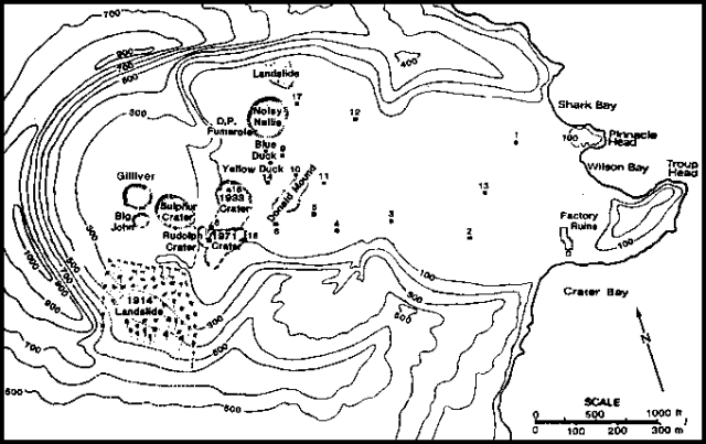 |
Figure 1. Main crater of White Island Volcano, showing the locations of various vents and fumaroles. [After Browne and Cole (1973).] |
6-7 January: Commercial pilots reported increased activity.
8 January: C. Hewson, S. Nathan, and two television reporters flew over White Island between 1450 and 1510. Light gray-brown ash was vigorously erupted. The vent appeared larger than on 30 December. Noisy Nellie was steaming strongly, but Donald Mound appeared less active, with only distinct fumaroles emitting steam. All visible parts of the island were mantled by light gray ash, estimated to be at least l cm thick on coastal vegetation; ash was much more widespread than on 30 December. The area within about 50 m of the vent was plastered with pale gray mud. No bomb craters were observed.
11 January: Victoria Univ. and NZGS scientists flew over White Island between 1110 and 1135. Steam, colored pale brown-gray by ash, billowed slowly to 800-900 m above sea level. The ash content of the eruption cloud was less than on 30 December. Since then, no more than l cm of ash appeared to have been deposited on the island. The active vents were larger and deeper, and covered the area of the 1971, Rudolf, and part of the 1933 craters [but see 2:2]. Minor fumaroles were noted on the outer slope of the volcano.
15 January: Two large eruptions were reported at 0830 and 1200, the eruption cloud from the latter reaching 1300 m.
17 January: J. Healy, B. Scott, and E. Lloyd (NZGS) overflew White Island between 1133 and 1146 and observed 1,000-m steam clouds containing some ash. The active vent seemed about the same size (150 m in diameter) as on 11 January. Although the observation period was brief, it appeared that the nature of the eruption had changed from continuous emission to one characterized by brief periods of little or no emission. The last eruption occurred 19-20 July, 1971.
[Reference. Browne, P.R.L., and Cole, J.W., 1973, Surveillance of White Island volcano, 1968-1972: New Zealand Journal of Geology and Geophysics, v. 16, no. 4, p. 959-963.]
Geological Summary. The uninhabited Whakaari/White Island is the 2 x 2.4 km emergent summit of a 16 x 18 km submarine volcano in the Bay of Plenty about 50 km offshore of North Island. The island consists of two overlapping andesitic-to-dacitic stratovolcanoes. The SE side of the crater is open at sea level, with the recent activity centered about 1 km from the shore close to the rear crater wall. Volckner Rocks, sea stacks that are remnants of a lava dome, lie 5 km NW. Descriptions of volcanism since 1826 have included intermittent moderate phreatic, phreatomagmatic, and Strombolian eruptions; activity there also forms a prominent part of Maori legends. The formation of many new vents during the 19th and 20th centuries caused rapid changes in crater floor topography. Collapse of the crater wall in 1914 produced a debris avalanche that buried buildings and workers at a sulfur-mining project. Explosive activity in December 2019 took place while tourists were present, resulting in many fatalities. The official government name Whakaari/White Island is a combination of the full Maori name of Te Puia o Whakaari ("The Dramatic Volcano") and White Island (referencing the constant steam plume) given by Captain James Cook in 1769.
Information Contacts: J. Cole, Victoria Univ., Wellington; D. Shackelford, Villa Park, CA.