Report on Seguam (United States) — March 1977
Natural Science Event Bulletin, vol. 2, no. 3 (March 1977)
Managing Editor: David Squires.
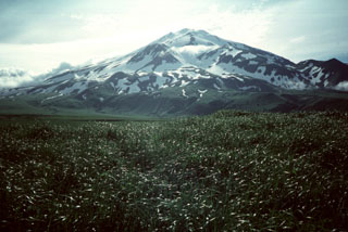
Seguam (United States) Lava fountaining from a 1-km-long rift seen on 6 March
Please cite this report as:
Global Volcanism Program, 1977. Report on Seguam (United States) (Squires, D., ed.). Natural Science Event Bulletin, 2:3. Smithsonian Institution. https://doi.org/10.5479/si.GVP.NSEB197703-311180
Seguam
United States
52.315°N, 172.51°W; summit elev. 1054 m
All times are local (unless otherwise noted)
Jürgen Kienle reported that on 6 March at about 0400, the crew of the USCG Cutter Mellon observed and photographed eruptive activity at the 750-m level of Pyre Peak, Seguam Island. Eight lava fountains rising to an estimated 90 m were observed along a l-km radial rift 2.5 km SW of Pyre Peak summit. Activity appeared to be progressing NE (towards the summit).
A lava flow formed and divided into two tongues. The larger was approximately 2.5 km long and l km wide. The smaller moved toward the S, and was approximately l km long and 0.5 km wide. Three dense black clouds were erupted from the vent during 2 hours of observation, after which the Mellon departed.
The nearest short-period seismometers, 225 km to the E (Nikolski), and 300 km to the W (Adak), were too far away to register any unusual earthquake activity.
Thomas Miller reported that on 8 March, a Reeve Aleutian Airlines flight passed over Seguam at low altitude. The pilot reported that lava effusion and fountaining had ended, but that a considerable amount of steam, possibly containing some ash, was being emitted from the fissure. Lava flows had not reached the sea. Poor weather during much of the year hampers aerial observation.
Several other ship reports of eruptions in the area have been received in the past several years. Seguam is uninhabited.
Geological Summary. The 11.5 x 24 km island of Seguam, between Amlia and Amukta Islands in the central Aleutians, contains two calderas with Holocene post-caldera cones. Growth of the basaltic-to-rhyolitic Wilcox volcano on the east side of the island during the late Pleistocene was followed by edifice collapse and an associated ignimbrite eruption about 9,000 years ago, leaving a caldera open to the west, inside which a rhyolitic cone was constructed. The 3 x 4 km westernmost caldera has a central scoria cone, Pyre Peak, which rises above the caldera rim and is the source of most of the reported eruptions. A very young basaltic field surrounds Pyre Peak, and lava flows partially fill the caldera and reach the southern coast. Older Holocene lava flows were erupted from vents within the eastern caldera, and a monogenetic Holocene cone forms Moundhill volcano on the eastern tip of the island.
Information Contacts: J. Kienle, Univ. of Alaska; T. Miller, USGS, Anchorage.