Report on Ukinrek Maars (United States) — April 1977
Natural Science Event Bulletin, vol. 2, no. 4 (April 1977)
Managing Editor: David Squires.
Ukinrek Maars (United States) Two new maars formed NW of Peulik volcano after 30 March
Please cite this report as:
Global Volcanism Program, 1977. Report on Ukinrek Maars (United States) (Squires, D., ed.). Natural Science Event Bulletin, 2:4. Smithsonian Institution. https://doi.org/10.5479/si.GVP.NSEB197704-312131
Ukinrek Maars
United States
57.8344°N, 156.5203°W; summit elev. 91 m
All times are local (unless otherwise noted)
Two new maars formed in tundra terrain, 15 km NW of Peulik volcano, between 30 March and 9 April. Explosions were first observed on 30 March from 70 km SW of the eruption site. Pilots who overflew the eruption at 1725 and 1800 reported a single vent, 20-30 m in diameter, that emitted white steam, then a dark, ash-laden cloud that rose 6,000-7,500 m. Fine ash fell 135 km ESE of the vent, and a sulfurous haze layer lay over Kodiak (250 km E of the vent) all day. More ash clouds were seen on 1 and 2 April.
On 2 April, the original crater had filled with water and become quiescent, and a new 60-m-diameter vent had formed 500 m to the E. By the early afternoon of 3 April, the E crater had grown to about 100 m in diameter and contained a yellowish-orange lava lake. Fragments up to 1 m across were being ejected to 300 m height. Later in the afternoon, 15-20-m lava fountains were observed.
An ash cloud rising more than 4,000 m deposited traces of ash 95 km to the N on 5 April, but by 6 April activity had declined to steam emission and some ash explosions, which sent tephra to more than 1,000 m above the lava lake. Similar activity, including 30-m orange-red lava fountains, was reported on 7 April. No further eruptions were reported until the early morning of 9 April, when violent explosions of incandescent material were seen 30 km away.
A team of volcanologists from the University of Alaska and Dartmouth College visited the eruption site 14-21 April. The W crater was oblong (150 x 65 m) and filled with lukewarm, slightly acidic water. The E crater was about 250 m in diameter and 100 m deep. About 2/3 of its floor was occupied by a lava dome up to 40 m high that was degassing and was coated with sulfur and hematite. Ground water emerged from the crater walls at 50-70 m depth and cascaded onto the dome, where it flashed to steam. Occasional ash puffs were created by the caving of the steep crater walls. Blocks and boulders of highly variable composition and various degrees of rounding, and olivine basalt bombs with lithic cores, decreased in size from 1.5 m in diameter near the crater rims to about 50 cm diameter a few hundred meters away. Fist-sized cinders fell as far as 2 km away. Stripped bark, and mud with imbedded scoria plastered against tree trunks 500 m from the vents, indicate at least minor base surge activity during 1 or more explosions of the E crater.
Two portable short-period seismograph systems, which operated from 15-20 April, recorded a high level of microearthquake activity and three distinct earthquake swarms of several hours duration. More than 1 event per minute was recorded during the swarms. Many of the smaller events were shallow, but some of the larger ones showed S-P times indicating hypocenter depths between a few km and 20 km. Some of the larger events were also recorded by a permanent University of Alaska seismic station 25 km N of the eruption site.
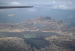
Geological Summary. Ukinrek Maars are two explosion craters that were created in an area without previous volcanic activity during a 10-day phreatomagmatic eruption March-April 1977. The basaltic maars were erupted through glacial deposits in the Bering Sea lowlands 1.5 km S of Becharof Lake and 12 km W of Peulik volcano; their location is related to the regional Bruin Bay fault. The elliptical West Maar, which was the first to form, is 105 x 170 m and 35 m deep. The other maar, 600 m to the east, is 300 m wide and 70 m deep. Both maars are now filled by crater lakes; the eastern lake encircles a 49-m-high lava dome that was emplaced at the end of the eruption. Base surges were directed primarily to the NW. Juvenile material from the Ukinrek eruptions was of mantle-derived olivine basaltic composition. The dacitic Gas Rocks lava domes, of Quaternary age, are located on the shores of Becharof Lake, 3 km N of Ukinrek maars and were the site of a phreatic eruption about 2,300 years ago.
Information Contacts: J. Kienle, Univ. of Alaska.