Report on Krafla (Iceland) — April 1977

Natural Science Event Bulletin, vol. 2, no. 4 (April 1977)
Managing Editor: David Squires.
Krafla (Iceland) Fissure eruption on 27 April causes ashfall and lava flows
Please cite this report as:
Global Volcanism Program, 1977. Report on Krafla (Iceland) (Squires, D., ed.). Natural Science Event Bulletin, 2:4. Smithsonian Institution. https://doi.org/10.5479/si.GVP.NSEB197704-373080
Krafla
Iceland
65.715°N, 16.728°W; summit elev. 800 m
All times are local (unless otherwise noted)
Inflation at Krafla continued irregularly until late April, while 100-130 earthquakes were recorded per day (figure 3).
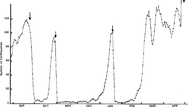 |
Figure 3. Five-day running average of the number of earthquakes per day at Krafla caldera, September 1976-April 1977. Deflation events are shown by down-arrows. Courtesy of Páll Einarsson. |
Harmonic tremor began at 1317 on 27 April, followed at about 1400 by series of earthquakes centered in a fissure swarm S of Krafla. About one magnitude 3.5-4.5 event occurred per minute during the swarm, which culminated at 1830. An eruption from a discontinuous fissure extending 3 km N from Leirhnjúkur (about 4 km W of Krafla) had begun before 1600, when a minor ashfall was recorded in the Mývatn area (about 10 km SW of Krafla). A 200 x 40 m lava flow was extruded from the N end of the fissure and steam and mud along the rest of its length. Tilt measurements indicate a 1-m subsidence of the caldera bottom in 17 hours, then renewed inflation after subsidence ended. New 2-m-wide fissures opened and fumarolic activity began in the Mývatn area, where more than 1 m of vertical displacement occurred, causing damage at a factory. Earthquakes continued on 1 May, but were declining.
Geological Summary. The Krafla volcanic system in the Northern Volcanic Zone (NVZ) of Iceland is about 100 km long, consisting of a fissure swarm and a central volcano with a 7 x 9 km caldera formed about 110,000 years ago that deposited a rhyolitic welded tuff. It has been moderately active in the Holocene, over three distinct eruptive periods; the current one has lasted about 2,800 years with six volcano-tectonic episodes, each with one or more basaltic fissure eruptions. Lava volumes (DRE) have been in the 0.1-1 km3 range. The Hverfjall and Ludent tuff rings east of Myvatn were erupted along the fissure system. Myvatn lake formed during the eruption of the older Laxarhraun lava flow from the Ketildyngja shield volcano of the Fremrinamur volcanic system about 3,800 years before present (BP); The present Myvatn lake is constrained by the roughly 2,000 years BP younger Laxarhraun lava flow from the Krafla volcanic system. The abundant pseudocraters that form a prominent part of the Myvatn landscape were created when the younger Laxarhraun lava flow entered the lake. The last eruption took place in 1975-1984 CE when nine small basaltic fissure eruptions produced 0.25 km3 of lava.
Information Contacts: G. Sigvaldason, NVI; P. Einarsson, Univ. of Iceland; H. Sigtryggsson, Icelandic Meteorological Office.