Report on Westdahl (United States) — February 1978
Scientific Event Alert Network Bulletin, vol. 3, no. 2 (February 1978)
Managing Editor: David Squires.
Westdahl (United States) Major ash eruption (about six days)
Please cite this report as:
Global Volcanism Program, 1978. Report on Westdahl (United States) (Squires, D., ed.). Scientific Event Alert Network Bulletin, 3:2. Smithsonian Institution. https://doi.org/10.5479/si.GVP.SEAN197802-311340
Westdahl
United States
54.516°N, 164.65°W; summit elev. 1563 m
All times are local (unless otherwise noted)
Data from satellite imagery and aircraft observations established that the eruption originated from the summit of Westdahl, one of five volcanoes on Unimak Island active in historical times. The eruption column was first visible in 5 February satellite imagery (figure 1), but Coast Guard personnel from Scotch Cap (15 km SW of Westdahl's summit) noted a sulfur odor during the evening of the 3rd and reported that ash had begun to fall by the next morning. Eruption column height was estimated at 8-10 km from aircraft observations on 6 February (figure 2) and up to 8 km from interpretation of satellite imagery (figure 3). Nearly 1 m of ash fell at Scotch Cap, forcing evacuation of its personnel and damaging Scotch Cap Light. Meltwater caused stream flooding and washed out the coast road. A Reeve Aleutian Airways pilot observed a new cinder cone, about 100 m in diameter, located near the site of Westdahl's last eruption (March-April, 1964). No lava flow has been observed. Activity declined to steaming after 9 February.
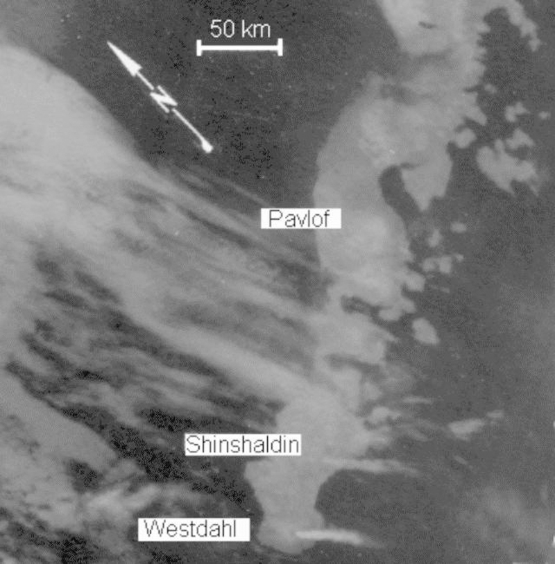 |
Figure 1. Enlargement of a portion of a NOAA 5 infrared image at 1835 on 8 February 1978 (0.9-km ground resolution), showing plumes, each about 60 km long, extending SE from both Westdahl and Shishaldin. Most of the Alaska Peninsula is visible, as is the coast of Alaska NW to the entrance to Kuskokwim Bay. The gray area off the coast is pack ice. Courtesy of Jürgen Kienle and NOAA. |
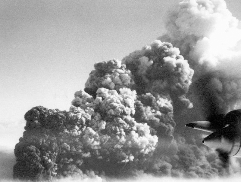 |
Figure 2. Oblique airphoto taken 6 February 1978 by George Wooliver (Reeve Aleutian Airways), showing Westdahl's eruption column emerging from the cloud layer at about 3000 m altitude. Wind is from the N at about 130 km/hr. Wooliver estimated that the top of the eruption column was at 8-10 km altitude. Courtesy of Thomas Miller. |
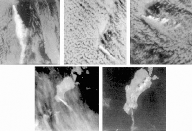 |
Figure 3. NOAA 5 satellite imagery, 5-9 February 1978, showing Unimak Island and vicinity. North orientations (arrow) are the same for each. A: (5 February 1978, 1036, infrared) Plume extends about 230 km S, rising to an estimated 8 km; black summit hot spot. B: (6 February 1978, 1141, infrared) Plume extends about 110 km SE; black summit hot spot. C: (7 February 1978, 1101, infrared) Plume at least 6 km high and about 160 km long, blown primarily SSE but some eastward shearing evident, probably by lower altitude winds. D: (8 February 1978, 1018, infrared) Plume extends 80 km SSE, at lower altitude than in C. E: (8 February 1978, 1018, visible, enlarged about 50% more than A-D) Weak plume curves SW to W about 100 km. Shishaldin is no longer active, 16 hours after its plume was visible in figure 11-2. The dark triangular area S of Westdahl is fresh ashfall, subtending an angle of about 95° and covering an area of about 300 km2. No ashfall is visible on Shishaldin. Courtesy of Jürgen Kienle and NOAA. |
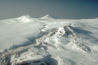
Geological Summary. Westdahl is a broad glacier-covered volcano occupying the SW end of Unimak Island. Two peaks protrude from the summit plateau, and a new crater formed in 1978 cuts the summit icecap. The volcano has a somewhat of a shield-like morphology and forms one of the largest volcanoes of the Aleutian Islands. The sharp-topped, conical Pogromni stratovolcano, 6 km N, rises several hundred meters higher than Westdahl, but is moderately glacially dissected and presumably older. Many satellitic cones of postglacial age are located along a NW-SE line cutting across the summit of Westdahl. Some of the historical eruptions attributed to the eroded Pogromni may have originated instead from Westdahl (Miller et al. 1998). The first historical eruption occurred in 1795. An 8-km-long fissure extending east from the summit produced explosive eruptions and lava flows in 1991.
Information Contacts: J. Kienle, Univ. of Alaska; T. Miller, USGS, Anchorage.