Report on Late (Tonga) — June 1979
Scientific Event Alert Network Bulletin, vol. 4, no. 6 (June 1979)
Managing Editor: David Squires.
Late (Tonga) No activity visible
Please cite this report as:
Global Volcanism Program, 1979. Report on Late (Tonga) (Squires, D., ed.). Scientific Event Alert Network Bulletin, 4:6. Smithsonian Institution. https://doi.org/10.5479/si.GVP.SEAN197906-243090
Late
Tonga
18.806°S, 174.65°W; summit elev. 540 m
All times are local (unless otherwise noted)
A message received from the ship MV Marama at 1445 on 31 May stated that... no activity was visible on Late.
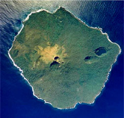
Geological Summary. The 6-km-wide circular island of Late, along the Tofua volcanic arc about 55 km WSW of Vavau, contains a 400-m-wide, 150-m-deep summit crater with an ephemeral lake. The largely submerged basaltic andesite to andesitic volcano rises 1,500 m from the sea floor, with its conical summit reaching 540 m above sea level. Cinder cones are found north of the summit crater, west and north of a semicircular plateau 100-150 m below the summit, and on the NW coast. A graben-like structure on the NE flank contains two large pit craters, the lower of which is partially filled by a saltwater lake. Eruptions from the NE-flank craters produced explosive activity and possible lava flows in 1790 and 1854.
Information Contacts: R. Richmond, Mineral Resources Dept., Fiji; J. Latter, DSIR, Wellington; S. Tongilava, Lands Survey and Natural Resources, Tonga; R. Jones, Air Tonga.