Report on Erebus (Antarctica) — March 1980
Scientific Event Alert Network Bulletin, vol. 5, no. 3 (March 1980)
Managing Editor: David Squires.
Erebus (Antarctica) Lava lake revisited
Please cite this report as:
Global Volcanism Program, 1980. Report on Erebus (Antarctica) (Squires, D., ed.). Scientific Event Alert Network Bulletin, 5:3. Smithsonian Institution. https://doi.org/10.5479/si.GVP.SEAN198003-390020
Erebus
Antarctica
77.53°S, 167.17°E; summit elev. 3794 m
All times are local (unless otherwise noted)
"The summit was visited by a Japan-New Zealand-U.S. group in December. The pattern of volcanic activity remains similar to that observed a year ago. Almost no change in the shape of the persistent anorthoclase phonolite (Kenyte) lava lake was noted. . . . The lake is oval, ~100 m long and 60 m wide, with total surface area approximately 4,500 m2. The lava lake level appears to be slightly lower, by ~3-5 m, compared to 1 year ago. A small distinct bench, l-5 m wide, occurs at several places around the perimeter of the lake and probably marks a former lake level, possibly that of last year. Five conspicuous fumarole vents were observed on the bench. Each vent was zoned by concentric bands of differently colored sublimates. Incandescent lava was observed beneath each vent.
"Convection of the lava lake was variable, with upwelling occurring about 1/3 of the distance from both ends of the lake. During periods of moderate convection, degassing was quiet and spread more evenly over the lava lake. Degassing bubbles were fewer, larger, and reached about 5-10 m in diameter. However, during stages of more active convection, degassing of the lava lake was noisy with more rapid upwelling. Explosive eruptions from the active vent continued at a frequency of ~2/day. One eruption was seen to eject bombs about 300 m above the vent. Minor ash eruptions occurred on two occasions.
"A tri-partite seismic array consisting of one horizontal and two vertical seismometers was operated for one week at the summit. The system detected explosive earthquakes as well as other shallow events not accompanied by explosive activity. Some of the larger explosions could be seen on the WWSSN station at Scott Base, 30 km away.
"Major element analyses of whole rock and interstitial glasses indicate no variation in chemical composition of the anorthoclase phonolite between December 1972 and December 1978. The lava lake probably represents the top of an extremely stable convection system, presumably connected at depth to a major magma chamber. No attempt was made to descend into the Main or Inner Craters this year."
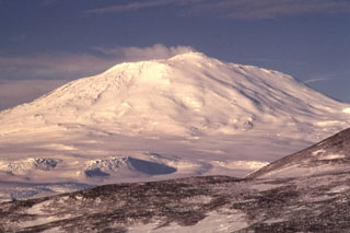
Geological Summary. Mount Erebus, the world's southernmost historically active volcano, overlooks the McMurdo research station on Ross Island. It is the largest of three major volcanoes forming the crudely triangular Ross Island. The summit of the dominantly phonolitic volcano has been modified by one or two generations of caldera formation. A summit plateau at about 3,200 m elevation marks the rim of the youngest caldera, which formed during the late-Pleistocene and within which the modern cone was constructed. An elliptical 500 x 600 m wide, 110-m-deep crater truncates the summit and contains an active lava lake within a 250-m-wide, 100-m-deep inner crater; other lava lakes are sometimes present. The glacier-covered volcano was erupting when first sighted by Captain James Ross in 1841. Continuous lava-lake activity with minor explosions, punctuated by occasional larger Strombolian explosions that eject bombs onto the crater rim, has been documented since 1972, but has probably been occurring for much of the volcano's recent history.
Information Contacts: P. Kyle, Ohio State Univ.

