Report on Krafla (Iceland) — July 1980
Scientific Event Alert Network Bulletin, vol. 5, no. 7 (July 1980)
Managing Editor: David Squires.
Krafla (Iceland) Large fissure and eruption
Please cite this report as:
Global Volcanism Program, 1980. Report on Krafla (Iceland) (Squires, D., ed.). Scientific Event Alert Network Bulletin, 5:7. Smithsonian Institution. https://doi.org/10.5479/si.GVP.SEAN198007-373080
Krafla
Iceland
65.715°N, 16.728°W; summit elev. 800 m
All times are local (unless otherwise noted)
"By the end of May, the land level over the magma reservoirs at Krafla had regained the height reached prior to the 16 March deflation and eruption. A new event was therefore expected as tiltmeters showed continuous height increase indicating further magma inflow into the reservoirs.
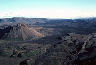
"On 10 July at about 0800, the continuously recording tiltmeters started to show rapid deflation and about 1 hour later volcanic tremor was noted on the seismometers. Earthquake activity was soon seen to migrate northwards along the Krafla fault swarm. At about 1245 an eruption started about 8 km N of the magma reservoirs. At least four groups of fissures were active extending over about 4 km. Activity was greatest during the first day but then decreased and concentrated in the northernmost crater group. The eruption then continued with decreasing vigor until 18 July when activity faded away in the early morning.
"The eruption took place far away from habitation so damage was minimal. The beginning of the eruption was observed from the air and on the ground by an unsuspecting tourist.
"The eruption was accompanied by large-scale fault movements close to the eruption site. Possibly the most spectacular sight was when large volumes of lava disappeared down into one of the faults about 3 km from the crater. This lasted for a few hours and the width of the falls was about 200 m.
"The lava covers 5-6 km2 and is much thicker than in previous eruptions. Preliminary volume estimates indicate that the volume of erupted lava exceeds that which left the central magma reservoirs. This is the first time during the Krafla rifting episode when no magma appears to have been added to the rift zone.
"Inflation of the magma reservoirs started again on 16 July, before the eruption was over. Inflation now continues at a high rate so that the Krafla rifting and magmatic episode continues."
Geological Summary. The Krafla volcanic system in the Northern Volcanic Zone (NVZ) of Iceland is about 100 km long, consisting of a fissure swarm and a central volcano with a 7 x 9 km caldera formed about 110,000 years ago that deposited a rhyolitic welded tuff. It has been moderately active in the Holocene, over three distinct eruptive periods; the current one has lasted about 2,800 years with six volcano-tectonic episodes, each with one or more basaltic fissure eruptions. Lava volumes (DRE) have been in the 0.1-1 km3 range. The Hverfjall and Ludent tuff rings east of Myvatn were erupted along the fissure system. Myvatn lake formed during the eruption of the older Laxarhraun lava flow from the Ketildyngja shield volcano of the Fremrinamur volcanic system about 3,800 years before present (BP); The present Myvatn lake is constrained by the roughly 2,000 years BP younger Laxarhraun lava flow from the Krafla volcanic system. The abundant pseudocraters that form a prominent part of the Myvatn landscape were created when the younger Laxarhraun lava flow entered the lake. The last eruption took place in 1975-1984 CE when nine small basaltic fissure eruptions produced 0.25 km3 of lava.
Information Contacts: K. Grönvold, NVI.

