Report on Kirishimayama (Japan) — January 1982

Scientific Event Alert Network Bulletin, vol. 7, no. 1 (January 1982)
Managing Editor: Lindsay McClelland.
Kirishimayama (Japan) Sulfur flow; fumarole temperature increase
Please cite this report as:
Global Volcanism Program, 1982. Report on Kirishimayama (Japan) (McClelland, L., ed.). Scientific Event Alert Network Bulletin, 7:1. Smithsonian Institution. https://doi.org/10.5479/si.GVP.SEAN198201-282090
Kirishimayama
Japan
31.934°N, 130.862°E; summit elev. 1700 m
All times are local (unless otherwise noted)
On 8 January JMA personnel discovered a 6-m-long, 30-cm-wide, 2-cm-thick sulfur flow that had emerged from Fumarole No. 6 in Shinmoe-dake (figure 1), a crater in the summit area of the Kirishima volcanic complex. Pieces of sulfur and tar-like material were scattered around the fumarole.
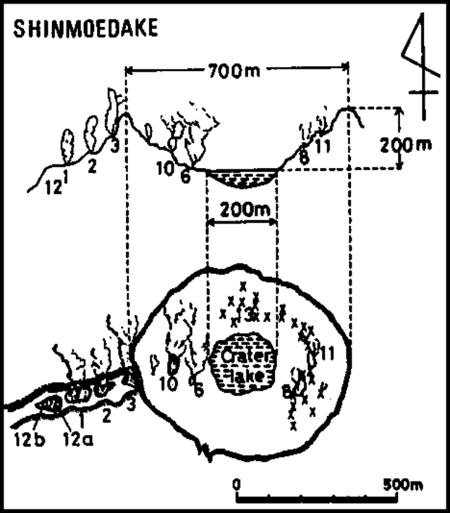 |
Figure 1. Cross-section and map of Shinmoe-dake crater at Kirishima. Numbers identify individual fumaroles. Courtesy of JMA. |
Increased geothermal activity was observed on the inner wall of Shinmoedake in December. The measured temperature of Fumarole No. 6 was 184°C, the highest since JMA's Kagoshima Observatory began summit area temperature measurements in 1979. Vegetation on the N inner wall had been damaged by the increased activity. Fumarolic activity in the Iodani area, about 5 km WSW of Shinmoedake, had increased from November 1980 through 1981. On 8 January JMA observers found that this activity had declined to its usual level. The last major activity at Shinmoedake was a steam explosion in 1959, when tephra was ejected, mainly from the fissure trending W from the crater.
Geological Summary. Kirishimayama is a large group of more than 20 Quaternary volcanoes located north of Kagoshima Bay. The late-Pleistocene to Holocene dominantly andesitic group consists of stratovolcanoes, pyroclastic cones, maars, and underlying shield volcanoes located over an area of 20 x 30 km. The larger stratovolcanoes are scattered throughout the field, with the centrally located Karakunidake being the highest. Onamiike and Miike, the two largest maars, are located SW of Karakunidake and at its far eastern end, respectively. Holocene eruptions have been concentrated along an E-W line of vents from Miike to Ohachi, and at Shinmoedake to the NE. Frequent small-to-moderate explosive eruptions have been recorded since the 8th century.
Information Contacts: JMA.