Report on Krafla (Iceland) — April 1982

Scientific Event Alert Network Bulletin, vol. 7, no. 4 (April 1982)
Managing Editor: Lindsay McClelland.
Krafla (Iceland) Slow inflation continues; previous activity summarized
Please cite this report as:
Global Volcanism Program, 1982. Report on Krafla (Iceland) (McClelland, L., ed.). Scientific Event Alert Network Bulletin, 7:4. Smithsonian Institution. https://doi.org/10.5479/si.GVP.SEAN198204-373080
Krafla
Iceland
65.715°N, 16.728°W; summit elev. 800 m
All times are local (unless otherwise noted)
"Rifting in the Krafla area with associated magmatic and eruptive activity has continued since December 1975. During the early phase of the episode, rifting and underground magma movement were the main features. Rifting occurred in individual relatively short events, the most recent in March 1980. Some of the rifting events were accompanied by eruptions but the volumes of the lavas were very small compared with the volumes of magma moving underground to fill the rifting segments. After March 1980 the character of the activity changed. Basaltic fissure eruptions are now the major feature but rifting is much less significant. A zone that now extends over 80 km has been rifted about 5-7 m.
"Since July 1980 there have been four basaltic fissure eruptions, each lasting 5-7 days. The lavas cover 30 km2 and their estimated volume is about 0.2 km3. The eruptive fissures extend 11 km N from Leirhnjúkur, which is situated right above the magma reservoirs and the center of inflation. In each eruption, only part of the eruptive fissures are active. Lava production has so far been dominantly from the N half of the fissure system. The most productive part of the fissure system is therefore situated near the center of the 80-km-long rifted zone, but the magma reservoirs that deflate during the eruptions are situated at the S end of the eruptive fissures. The chemical composition of the glasses indicates a more complex pattern than simple magma reservoirs draining magma to the surface.
"The pattern of inflation of the magma reservoirs between eruptions, and deflation during eruptions, has remained very regular (figure 5). Eruptions take place only after the inflation of the magma reservoirs has reached well over the level of the previous inflation. After the most recent eruption in November 1981 the magma reservoirs inflated again and the previous ground levels were reached in early January. At present, inflation continues very slowly and an eruption at any time during the next few months would come as no surprise."
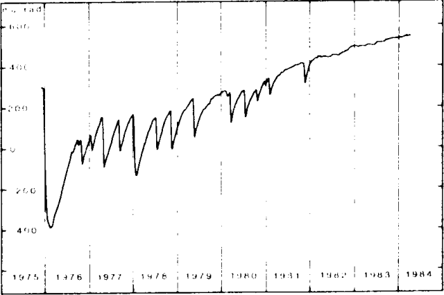 |
Figure 5. Inflation/deflation sequence in the Krafla region, 1975-82, as measured by the N-S component of the water-tube tiltmeter in the Krafla power station, ~1.5 km S of the center of inflation/deflation. One µrad of tilt corresponds to ~3.4 mm of vertical ground displacement at the center of inflation/deflation. From Tryggvason (1984). [Not in original SEAN report.] |
Geological Summary. The Krafla volcanic system in the Northern Volcanic Zone (NVZ) of Iceland is about 100 km long, consisting of a fissure swarm and a central volcano with a 7 x 9 km caldera formed about 110,000 years ago that deposited a rhyolitic welded tuff. It has been moderately active in the Holocene, over three distinct eruptive periods; the current one has lasted about 2,800 years with six volcano-tectonic episodes, each with one or more basaltic fissure eruptions. Lava volumes (DRE) have been in the 0.1-1 km3 range. The Hverfjall and Ludent tuff rings east of Myvatn were erupted along the fissure system. Myvatn lake formed during the eruption of the older Laxarhraun lava flow from the Ketildyngja shield volcano of the Fremrinamur volcanic system about 3,800 years before present (BP); The present Myvatn lake is constrained by the roughly 2,000 years BP younger Laxarhraun lava flow from the Krafla volcanic system. The abundant pseudocraters that form a prominent part of the Myvatn landscape were created when the younger Laxarhraun lava flow entered the lake. The last eruption took place in 1975-1984 CE when nine small basaltic fissure eruptions produced 0.25 km3 of lava.
Information Contacts: K. Grönvold, NVI; K. Saemundsson, National Energy Authority.