Report on El Chichon (Mexico) — October 1982
Scientific Event Alert Network Bulletin, vol. 7, no. 10 (October 1982)
Managing Editor: Lindsay McClelland.
El Chichon (Mexico) High H2S and NO in plume; slow diffusion of stratospheric cloud
Please cite this report as:
Global Volcanism Program, 1982. Report on El Chichon (Mexico) (McClelland, L., ed.). Scientific Event Alert Network Bulletin, 7:10. Smithsonian Institution. https://doi.org/10.5479/si.GVP.SEAN198210-341120
El Chichon
Mexico
17.3602°N, 93.2297°W; summit elev. 1150 m
All times are local (unless otherwise noted)
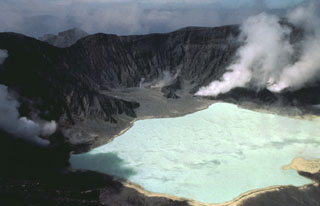
As of early November, no new eruptive activity has been reported from El Chichón since the small ash ejection of 11 September described last month. Mexican and American geologists flew over the volcano on 4 November (during the NASA mission to observe the stratospheric cloud ejected 4 April). Little new vegetation could be seen on the volcano and 1ahar deposits were evident in stream valleys. The two crater lakes observed in September had combined into a single bright yellow-green lake that covered more than 80% of the crater floor. A sulfur slick covered the lake and sulfur deposits were visible along its shore. Vapor was emitted from 6-8 vents distributed around the shore and churning of the lake water indicated that gases were also emerging from sources beneath its surface. The gas emission fed a relatively diffuse, low-altitude plume that was visible within ~ 15 km of the volcano. Filter samples collected from the NASA aircraft showed that the plume was relatively poor in ash. The ratio of NO (measured by a chemoluminescent technique) to total sulfur gases (analyzed by flame photometry) was an order of magnitude higher in the El Chichón plume than at Arenal, Poás, Colima, and Mt. St. Helens during similar sampling in February. H2S made up more than 95% of the sulfur gases in the plume.
Michael Matson provided additional data on the initial heights and subsequent directions of movement of different layers of the eruption clouds from the largest El Chichón explosions (table 1). Blackbody temperatures of the tops of dense eruption columns are determined from GOES East geostationary weather satellite digital data, and are compared to temperature/altitude profiles from radiosondes launched from Veracruz, México (19.15°N, 96.12°W) at 0600 and 1800 daily. Note that the cloud top temperatures are usually for eruption columns that have just been ejected from the volcano and thus have not yet reached their maximum altitudes. Accurate temperatures cannot be assigned to diffuse plumes because data from the plume are mixed with data from the underlying terrain. However, their direction and speed of drift can be measured on a series of satellite images and then compared with known wind directions and speeds at various heights (in this case from the Veracruz radiosondes) to estimate altitudes.
Table 1. Determinations from satellite and radiosonde data of initial cloud top altitudes (rows with temperature and tropopause data) and later downwind drift of ejecta (rows with drift data) from the four largest explosions of El Chichón, March-April 1982. Altitudes could not be determined for the two largest clouds, marked by an asterisk (*) because they yielded unrealistically low temperatures, indicating that they did not radiate as perfect blackbodies, perhaps because of high tephra content. [Carey and Sigurdsson (1986) calculate average column altitudes of 20, 24, and 22 km respectively for the 29 March and the two 4 April explosions.]
| Date | Time | Temperature (°C) | Tropopause (km) | Altitude (km) | Direction of Drift |
| 29 Mar 1982 | 0230 | -75.2 | 16.5 | 16.3 | -- |
| 1500 | -- | -- | 0-5.6 | SW | |
| -- | -- | 10.4-15.2 | NE | ||
| -- | -- | 24 | SW | ||
| 03 Apr 1982 | 0400 | -71.2 | 17 | 15.1 | -- |
| 0900 | -- | -- | 0-4.9 | SW | |
| -- | -- | 13.7-16.3 | NE | ||
| 2200 | -78.2 | 16.9 | * | -- | |
| 04 Apr 1982 | 0100 | -- | -- | 13.7-18.5 | NE |
| -- | -- | 20.7-24 | SW | ||
| 0744 | -83.0 | 16.9 | * | -- | |
| 1730 | -- | -- | 9.2-20.7 | NE | |
| -- | -- | 24-31 | SW |
Further Reference. Carey, S.N. and Sigurdsson, H., 1986, The 1982 Eruptions of El Chichón Volcano México (2): observations and numerical modelling of tephra-fall distribution: BV, v. 48, no. 2/3, p. 127-141.
Geological Summary. El Chichón is a small trachyandesitic tuff cone and lava dome complex in an isolated part of the Chiapas region in SE México. Prior to 1982, this relatively unknown volcano was heavily forested and of no greater height than adjacent non-volcanic peaks. The largest dome, the former summit of the volcano, was constructed within a 1.6 x 2 km summit crater created about 220,000 years ago. Two other large craters are located on the SW and SE flanks; a lava dome fills the SW crater, and an older dome is located on the NW flank. More than ten large explosive eruptions have occurred since the mid-Holocene. The powerful 1982 explosive eruptions of high-sulfur, anhydrite-bearing magma destroyed the summit lava dome and were accompanied by pyroclastic flows and surges that devastated an area extending about 8 km around the volcano. The eruptions created a new 1-km-wide, 300-m-deep crater that now contains an acidic crater lake.
Information Contacts: J. Friend, Drexel Univ.; S. de la Cruz-Reyna, UNAM, México; M. Matson, NOAA/NESS.