Report on Telica (Nicaragua) — April 1983
Scientific Event Alert Network Bulletin, vol. 8, no. 4 (April 1983)
Managing Editor: Lindsay McClelland.
Telica (Nicaragua) Increased seismicity and fumarolic activity in February
Please cite this report as:
Global Volcanism Program, 1983. Report on Telica (Nicaragua) (McClelland, L., ed.). Scientific Event Alert Network Bulletin, 8:4. Smithsonian Institution. https://doi.org/10.5479/si.GVP.SEAN198304-344040
Telica
Nicaragua
12.606°N, 86.84°W; summit elev. 1036 m
All times are local (unless otherwise noted)
After a tephra eruption ended 1 March 1982, seismicity returned to normal. Through November 1982 about 14 events were recorded per day. On 10 February 1983 a portable seismograph installed on the flank recorded 66 earthquakes. This increase was paralleled by stronger fumarolic activity on the S, SE, and SW part of the volcano.
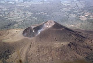
Geological Summary. Telica, one of Nicaragua's most active volcanoes, has erupted frequently since the beginning of the Spanish era. This volcano group consists of several interlocking cones and vents with a general NW alignment. Sixteenth-century eruptions were reported at symmetrical Santa Clara volcano at the SW end of the group. However, its eroded and breached crater has been covered by forests throughout historical time, and these eruptions may have originated from Telica, whose upper slopes in contrast are unvegetated. The steep-sided cone of Telica is truncated by a 700-m-wide double crater; the southern crater, the source of recent eruptions, is 120 m deep. El Liston, immediately E, has several nested craters. The fumaroles and boiling mudpots of Hervideros de San Jacinto, SE of Telica, form a prominent geothermal area frequented by tourists, and geothermal exploration has occurred nearby.
Information Contacts: D. Fajardo B., INETER.

