Report on Kusatsu-Shiranesan (Japan) — December 1983
Scientific Event Alert Network Bulletin, vol. 8, no. 12 (December 1983)
Managing Editor: Lindsay McClelland.
Kusatsu-Shiranesan (Japan) Summit explosions and seismicity
Please cite this report as:
Global Volcanism Program, 1983. Report on Kusatsu-Shiranesan (Japan) (McClelland, L., ed.). Scientific Event Alert Network Bulletin, 8:12. Smithsonian Institution. https://doi.org/10.5479/si.GVP.SEAN198312-283120
Kusatsu-Shiranesan
Japan
36.618°N, 138.528°E; summit elev. 2165 m
All times are local (unless otherwise noted)
Summit explosions from Kusatsu-Shirane occurred on 13 November and 21 December. Precursory seismic activity began with a large-amplitude discrete event on 2 November. Tremor was continuous between 0700 and 2000 on the 10th. Stronger tremor was recorded at 1722 on the 12th. Its mean amplitude on the seismograph, initially 1.9 µm, gradually increased to more than 5.0 µm at 2000, when the wave form of the tremor became similar to one that had accompanied a mud at Aso Volcano. Tremor gradually declined during the early morning of 13 November.
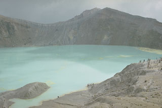
Explosions occurred 13 November at 1144 and 1208 from small vents (Pits No. 6 and 7) on Yugama Crater's [N] wall and a new pit that appeared about 50 m E of Pit No. 6. [During a 22 December inspection] Tokyo Institute of Technology personnel found that a [45] cm-wide, 45 m-long fissure on the N wall of the adjoining Karagama Crater had also ejected ash. JMA noted that the line extending SW from Pit No. 6 across Karagama Crater's N wall has been active since the eruption of October 1982.
Lapilli were scattered as much as 600-700 m S of Yugama. Ash was carried 30 km downwind although most fell into the lake in Yugama Crater. The second explosion was accompanied by a ground shock of intensity III (JMA Scale) at the rest area 700 m S of Yugama. Signals from the seismograph at the Maebashi District Meteorological Observatory stopped immediately after this explosion. A field survey revealed that [blocks] had made many craters 1-3 m in diameter and 50 cm deep on the upper SE outer slope of Yugama. The buried seismograph cable seemed to have been cut by one of these [blocks].
Seismic activity increased again 18-19 December, when 32 and 31 discrete events were recorded. After a brief period of activity from 0954-1007 on the 21st, continuous tremor resumed at 1022. The tremor, accompanied by some large discrete events, saturated the seismograph from 1035-1105, then gradually declined, ending at 1220.
A Kusatsu town employee working S of Yugama first noticed the sound of vapor emission at 1010; 20 minutes later he observed a dark plume containing mud and lapilli rising 300 m above the crater rim. Ash traveled 400-500 m SE, darkening frozen Yugama Lake. Eruptive activity began to decline about 1100. Tokyo Institute of Technology personnel found that the eruption sites were Pits No. 2 and 3 on the W inner wall of Yugama. A small amount of ash was also ejected from the fissure in Karagama Crater that was active in November.
Geological Summary. The Kusatsu-Shiranesan complex, located immediately north of Asama volcano, consists of a series of overlapping pyroclastic cones and three crater lakes. The andesitic-to-dacitic volcano was formed in three eruptive stages beginning in the early to mid-Pleistocene. The Pleistocene Oshi pyroclastic flow produced extensive welded tuffs and non-welded pumice that covers much of the E, S, and SW flanks. The latest eruptive stage began about 14,000 years ago. Historical eruptions have consisted of phreatic explosions from the acidic crater lakes or their margins. Fumaroles and hot springs that dot the flanks have strongly acidified many rivers draining from the volcano. The crater was the site of active sulfur mining for many years during the 19th and 20th centuries.
Information Contacts: JMA, Tokyo.