Report on Villarrica (Chile) — November 1984

Scientific Event Alert Network Bulletin, vol. 9, no. 11 (November 1984)
Managing Editor: Lindsay McClelland.
Villarrica (Chile) Lava carves channels in ice; bulge on opposite flank
Please cite this report as:
Global Volcanism Program, 1984. Report on Villarrica (Chile) (McClelland, L., ed.). Scientific Event Alert Network Bulletin, 9:11. Smithsonian Institution. https://doi.org/10.5479/si.GVP.SEAN198411-357120
Villarrica
Chile
39.42°S, 71.93°W; summit elev. 2847 m
All times are local (unless otherwise noted)
The first paragraph is from a report from Oscar González-Ferrán. The quoted material is from a report from Hugo Moreno, Leopoldo López Escobar, Pedro Riffo A., and Gustavo Fuentealba.
Villarrica began to erupt on 30 October. Activity was generally similar to that of the 1971-72 eruption. A very fluid basaltic lava column ascended the central crater without the emission of pyroclastics. Gases escaped freely, generating explosions in the crater that ejected lava spatter to 20-100 m in height, forming a spatter cone. Lava flowed NE from the base of this cone over the snow and ice that cover the upper flanks, excavating a channel and generating a large column of vapor. The Emergency Office took preventive measures to protect the population against possible avalanches. As of mid-November, the level of lava in the central crater continued to rise.
"On 30 October at 1745, authorities 16 km N of the summit (in Pucón) reported that explosions were occurring in the central crater and a small lava flow was pouring out from the NNE side of the crater through a small V-shaped opening left by the 1971 fissure eruption. The lava moved across the ice, quenched, and generated an avalanche mixed with ice and snow that reached 5 km from the summit (phase 1, figure 1).
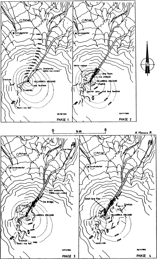 |
Figure 1. Sketch map of the summit area and N flank of Villarrica on 30 October and 3, 13, and 18 November 1984. Courtesy of Hugo Moreno. |
"Lava was emitted continuously from the central crater, advancing toward the NNE, where it melted the ice cover and formed a channel that was estimated to be 30-40 m deep, 50 m wide, and 1 km long during aerial observations 2-3 November. The central crater was occupied by a small flat spatter cone showing weak Strombolian activity. Lava from a small lake at the NNE foot of the spatter cone poured into the ice channel. Over the flat bottom of the channel, formed by solidified black lava, two narrow red lava flows were observed. Voluminous quantities of water vapor emerged from the area where the lava flow front was in contact with the channel's steep ice wall. Numerous fissures were present in the ice surrounding the channel, and on 3 November the ice cover on the SW flank also showed several deep fissures (phase 2, figure 1).
"Weather conditions obscured the volcano 4-5 November, but seismometers operated by the Universidad de la Frontera at Temuco recorded intense shallow seismicity (0-1 km depth), [tremors] and B-type [earthquakes] (table 1).
Table 1. Number of B-type events and [tremors] recorded by seismometers at Temuco, from 4 November, 2100, to 0635 the next day.
| Date | Time | B-type | Tremors |
| 04 Nov 1984 | 2100-0100 | 4 | -- |
| 05 Nov 1984 | 0100-0200 | 5 | -- |
| 05 Nov 1984 | 0200-0300 | 9 | -- |
| 05 Nov 1984 | 0300-0400 | 8 | -- |
| 05 Nov 1984 | 0400-0500 | 3 | 4 |
| 05 Nov 1984 | 0500-0600 | 8 | 2 |
| 05 Nov 1984 | 0600-0635 | 9 | -- |
"There were no signs of eruptive activity 6-9 November, although tremors and underground rumbling were reported at Pucón. Strombolian activity at the small spatter cone in the central crater resumed 10-12 November, and lava flowed NNE into the ice channel. The speed of the flow was estimated at 10 m/s.
"As of midday on 13 November, almost 2 x 10⁶ m3 of lava had flowed into the ice channel, most of which was concentrated at the lava front under the ice cover. At 1350 on the 13th, the lava front emerged onto the surface, generating a 3 km-long avalanche of lava blocks, ice, and snow, and leaving behind a 150 m-long ice bridge. Since only a very small mudflow moved downstream, it seems that most of the water generated by melting of the ice evaporated. New fissures were observed on the ice-covered SW, E, and NE flanks (phase 3, figure 1).
"Eruptive activity decreased 14-17 November, with only weak fumarolic emissions seen at the spatter cone and water vapor emission at the ice bridge. [Earthquakes] were reported 13 km E and 10 km SW of the volcano (at Palguin and Chaillupen).
"On 18 November, a clear deformation of the SW slope was observed between 2,200 and 2,800 m above sea level. Weak lava production from the central crater opened a new small ice channel, about 200 m long and 50 m wide, toward the N (phase 4, figure 1).
"Villarrica's October-November eruptive behavior is quite similar to the 1971 eruptive cycle that ended in a big lava effusion (29 December at 2345). Villarrica last erupted 11 August and during the first week in September, with small explosions and tephra emissions."
Geological Summary. The glacier-covered Villarrica stratovolcano, in the northern Lakes District of central Chile, is ~15 km south of the city of Pucon. A 2-km-wide caldera that formed about 3,500 years ago is located at the base of the presently active, dominantly basaltic to basaltic andesite cone at the NW margin of a 6-km-wide Pleistocene caldera. More than 30 scoria cones and fissure vents are present on the flanks. Plinian eruptions and pyroclastic flows that have extended up to 20 km from the volcano were produced during the Holocene. Lava flows up to 18 km long have issued from summit and flank vents. Eruptions documented since 1558 CE have consisted largely of mild-to-moderate explosive activity with occasional lava effusion. Glaciers cover 40 km2 of the volcano, and lahars have damaged towns on its flanks.
Information Contacts: O. González-Ferrán, H. Moreno R., and L. López E., Univ. de Chile, Santiago; P. Riffo A. and G. Fuentealba C., Univ. de la Frontera, Temuco.