Report on Krafla (Iceland) — November 1984

Scientific Event Alert Network Bulletin, vol. 9, no. 11 (November 1984)
Managing Editor: Lindsay McClelland.
Krafla (Iceland) End of eruption described; tilt data; lava flows mapped
Please cite this report as:
Global Volcanism Program, 1984. Report on Krafla (Iceland) (McClelland, L., ed.). Scientific Event Alert Network Bulletin, 9:11. Smithsonian Institution. https://doi.org/10.5479/si.GVP.SEAN198411-373080
Krafla
Iceland
65.715°N, 16.728°W; summit elev. 800 m
All times are local (unless otherwise noted)
"The early phase of the September eruption (9:8) was very similar to previous eruptions. Maximum eruptive activity was reached within about 1 hour, and while the whole 8.5-km-long fissure was active thin fluid lava advanced along the entire zone (figure 8). In the early hours of the eruption's first morning, 5 September, activity decreased rapidly, dying out on many of the fissure segments, especially in the southern half. By 6 September only one crater remained active, just S of the N end of the original fissure.
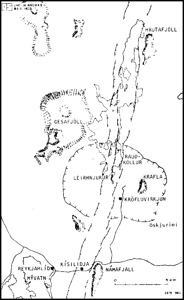 |
Figure 8. Sketch map of the Krafla area by Kristjan Saemundsson (NVI) made with the aid of airphotos by Oddur Sigurdsson at the same institute. Lava flows from the September 1984 eruption are shown in a stipple pattern. Courtesy of Karl Grönvold. |
"By midday 5 September, while activity was dying out along most of the fissure, deflation over the magma reservoirs below Leirhnjúkur stopped and inflation began (figure 9). This situation changed on 9 September when deflation resumed. Around the same time, activity at the one remaining crater increased. Deflation and relatively vigorous eruption continued until the afternoon of 18 September when activity at the crater died out and inflation resumed. The inflation pattern since then is similar to that following previous eruptions.
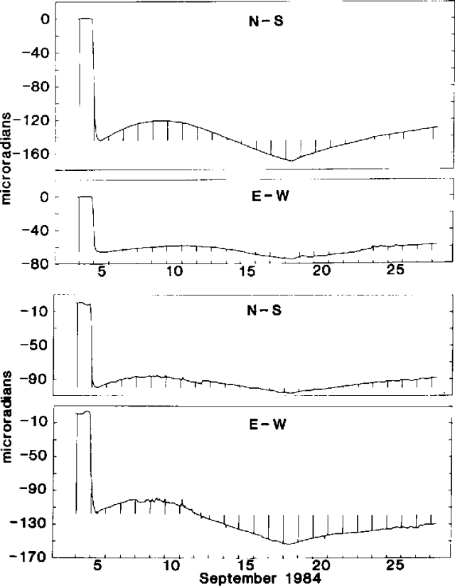 |
Figure 9. Tilt at the Krafla powerhouse (Kröfluvirkjun), top, and Víti (~3 km NE of the powerhouse), bottom, 4-27 September 1984. Vertical lines are time signals at midnight. Courtesy of Gudmundur Sigvaldason. |
"The new lava covers about 24 km2 and the total area now covered by Krafla lava is about 36 km2. As in some of the previous eruptions lava was observed flowing into older fissures, causing secondary rifting. Sometimes this lava reemerged farther along the fissures. Flames from burning gas were widely observed near the flow margin."
Further Reference. Tryggvason, E., 1986, Multiple magma reservoirs in a rift zone volcano: ground deformation and magma transport during the September 1984 eruption of Krafla, Iceland: JVGR, v. 28, p. 1-44.
Geological Summary. The Krafla volcanic system in the Northern Volcanic Zone (NVZ) of Iceland is about 100 km long, consisting of a fissure swarm and a central volcano with a 7 x 9 km caldera formed about 110,000 years ago that deposited a rhyolitic welded tuff. It has been moderately active in the Holocene, over three distinct eruptive periods; the current one has lasted about 2,800 years with six volcano-tectonic episodes, each with one or more basaltic fissure eruptions. Lava volumes (DRE) have been in the 0.1-1 km3 range. The Hverfjall and Ludent tuff rings east of Myvatn were erupted along the fissure system. Myvatn lake formed during the eruption of the older Laxarhraun lava flow from the Ketildyngja shield volcano of the Fremrinamur volcanic system about 3,800 years before present (BP); The present Myvatn lake is constrained by the roughly 2,000 years BP younger Laxarhraun lava flow from the Krafla volcanic system. The abundant pseudocraters that form a prominent part of the Myvatn landscape were created when the younger Laxarhraun lava flow entered the lake. The last eruption took place in 1975-1984 CE when nine small basaltic fissure eruptions produced 0.25 km3 of lava.
Information Contacts: K. Grönvold and G. Sigvaldason, NVI; P. Einarsson, Univ. of Iceland.