Report on Etna (Italy) — March 1985
Scientific Event Alert Network Bulletin, vol. 10, no. 3 (March 1985)
Managing Editor: Lindsay McClelland.
Etna (Italy) S-flank fissure eruption preceded by seismicity and tilt
Please cite this report as:
Global Volcanism Program, 1985. Report on Etna (Italy) (McClelland, L., ed.). Scientific Event Alert Network Bulletin, 10:3. Smithsonian Institution. https://doi.org/10.5479/si.GVP.SEAN198503-211060
Etna
Italy
37.748°N, 14.999°E; summit elev. 3357 m
All times are local (unless otherwise noted)
The following is a report from Romolo Romano. Additional information about the eruptive activity from French volcanologists has been inserted in parentheses in this section. Their report of seismicity and tilt associated with the eruption is presented below.
"Explosive and effusive activity occurred 8-10 March from the Southeast Crater (French volcanologists noted that a strong but short-lived phase of the Southeast Crater activity started 10 March at 1100, with vigorous lava fountaining and overflow of lava toward the Valle del Bove). After numerous fractures formed 11 March on the upper S flank between 3,000 and 2,600 m above sea level, an exclusively effusive vent opened 12 March at 2,620 m elevation, with no recorded seismic activity. The same day, three more effusive vents opened at lower elevations (2,600, 2,510, and 2,490 m); only the last two (near Piccolo Rifugio) remained active. The lava flows that originated from these vents moved mainly toward the S and SW, giving rise to numerous individual lobes. Near the vent at 2,510 m elevation, weak explosive activity occurred, soon creating several small spatter cones and hornitos.
"On 14 March, the lava flows moving S destroyed two Etna cableway pylons; the cable broke the next day. The longest flow stopped 15 March at 2,080 m elevation. Along this trend, superposing lava flows were noted during the following days, until the effusive activity from the vent at 2,490 m ceased on 23 March.
"The lava flows that moved SW created an extensive lava field (maximum width 500 m). At 2,100 m elevation the lava field split into at least five lobes. The longest (and easternmost) flow had descended to 1,850 m elevation by 4 April, covering a distance of ~3 km.
"As of early April, the main lava channel had become a lava tubelava tube between 2,450 and 2,300 m above sea level. Short-lived effusive vents opened near the lower end of the tubelava tube, with lava flows approaching the E side of the lava field or flowing over it. The velocity of the lava flows varied from a few meters per hour to ~30 m/hour. The surface covered by the lava can be estimated at around 2.5 km2 and the volume of lava at ~12 x 106 m3. The temperature of lava at the vents was around 1,050°C.
"Particularly during the first few days of the eruption, because of the snow cover, several mudflows formed ahead of the lava flows. Phreatic explosions, violent at times (25 March) were also observed. During the eruption, more or less vigorous emission of vapor, gas, and rarely ash occurred from the central crater vents. (French volcanologists reported a strong explosion from the Chasm on 1 April at about 1625). Isolated expulsions of dark ash from Northeast Crater were observed.
"Collection of information on the eruptive activity was possible thanks to the cooperation of the following Italian Alpine Club rescue team guides and volunteers: G. Baglio, A. Cariola, A. Cristaudo, C. Ferlito, A. Nicotra, G. Puglisi, and F. Zipper."
Later newspaper reports described a swarm of about 30 earthquakes, some reaching intensities of MM IV-V, that started 7 April and continued until early on the 9th. The events were felt most strongly in the towns of Santa Venerina, Acireale, and Giarre (14.5 km SE, 20 km SE, and 17 km ESE of the central craters). After the swarm, the rate of lava production increased by a factor of about 1/3.
The following report, on activity monitored through the ARGOS system, is from PIRPSEV, CNRS-INAG, in the context of French-Italian cooperation.
"Two geophones and a Blum pendulum inclinometer, connected with ARGOS for telerecording of the data, operate near the summit (TDF) and on the south flank (SLN) (figure 17). The geophones record both earthquakes and pulses of volcanic tremor as seismic events, and appear to be good indicators of seismic activity linked to volcanism. The eruption was preceded by an increase in seismic activity (mainly tremor energy) as indicated by the two geophones (TDF and SLN, figure 18). However, after the Southeast Crater eruption, the tremor energy returned to very low levels (figure 19), although effusive vents subsequently opened on the S flank.
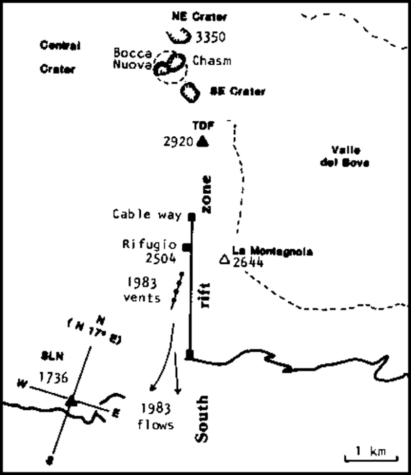 |
Figure 17. Sketch map of the summit and south flank of Etna, showing locations of geophones at Torre del Filosofo (TDF) and Serra la Nave (SLN), and orientation of the tiltmeter at SLN. |
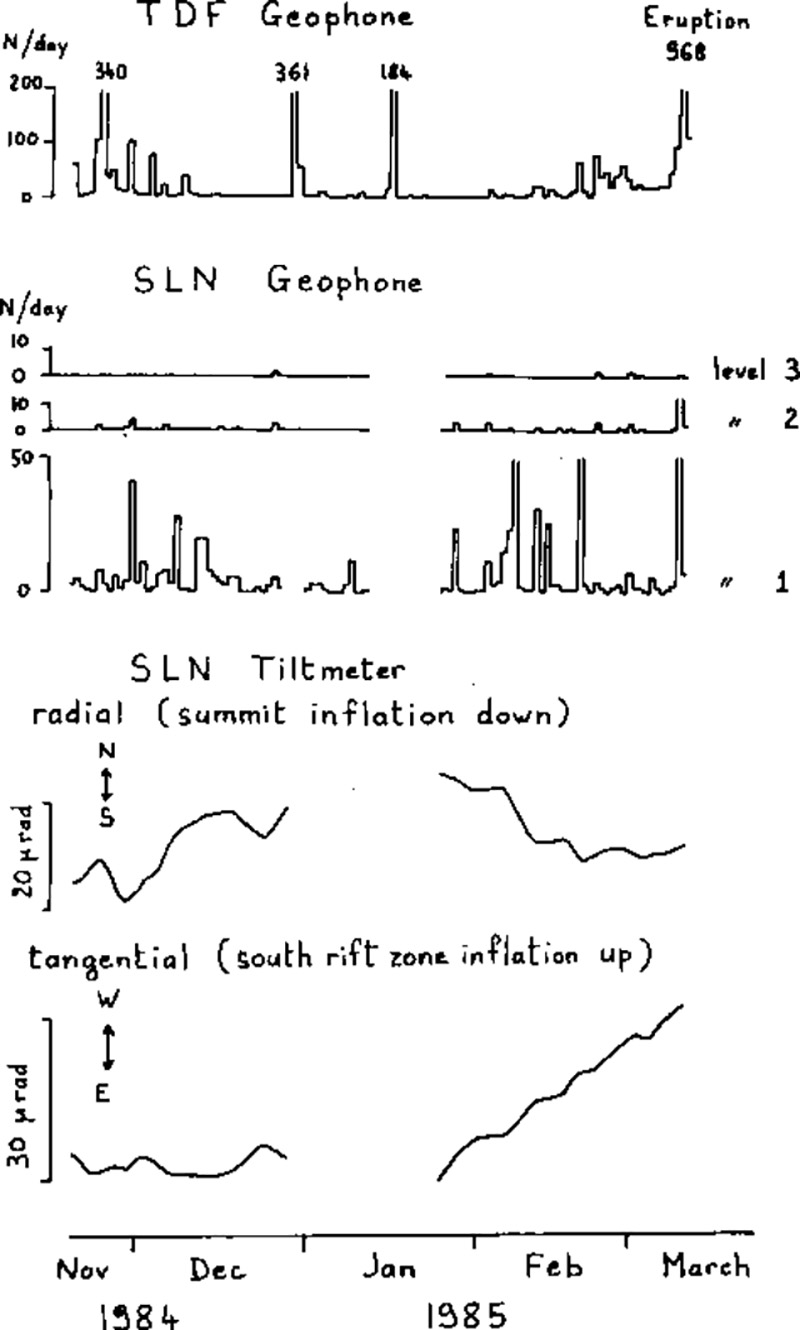 |
Figure 18. Seismicity (number of events per day), top, and tilt, bottom, preceding the 10 March eruption, recorded by the geophones at TDF and SLN, and the SLN tiltmeter. The TDF geophone detection level is 6µm/sec, the three SLN levels are 1.8, 9, and 45 µm/s. |
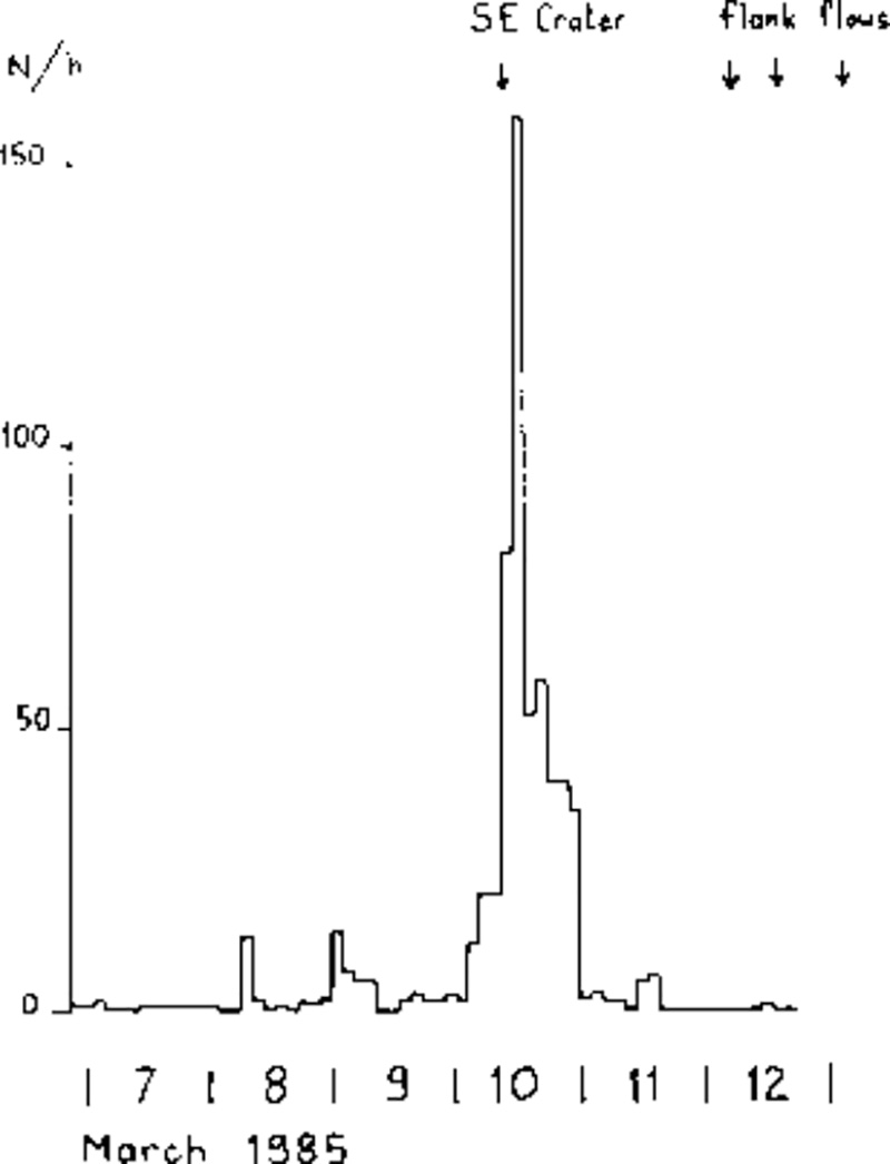 |
Figure 19. Number of events per hour recorded by TDF geophone, 7-12 March 1985, showing a strong increase during the Southeast Crater eruption. Arrows at top indicated that eruption and the production of flank lava flows. |
"The SLN inclinometer showed continuous tilt toward the WSW during early February, consistent with inflation on the site of the 1983 (and March 1985) eruptions (figure 18). Since mid-February, however, tilt has been mainly westward (figures 20 and 21), thus indicating inflation lower on the S rift zone. This change appears almost synchronous with the appearance of new frequencies of volcanic tremor (personal communication by S. Gresta)."
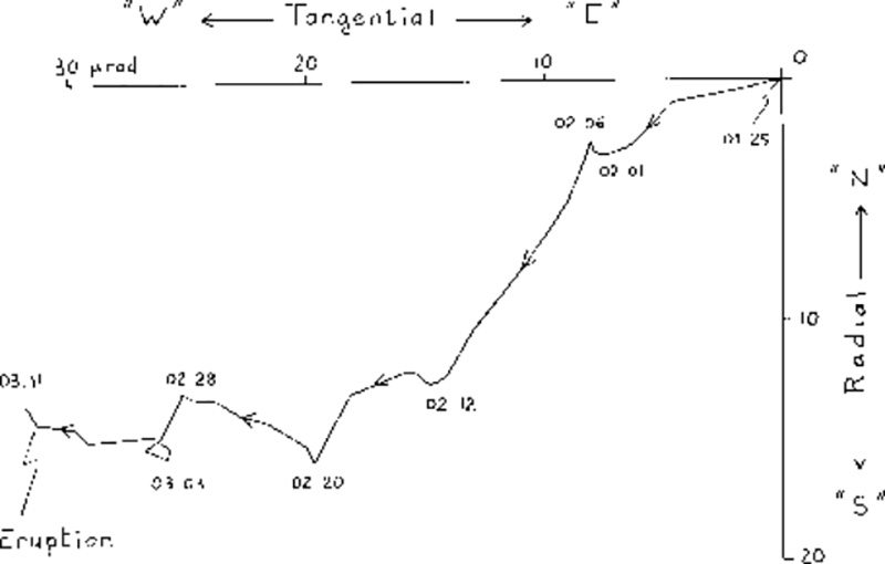 |
Figure 20. Tangential vs. radial component of the SLN tiltmeter, 25 January- 11 March 1985 (S rift zone inflation westward, summit inflation southward). |
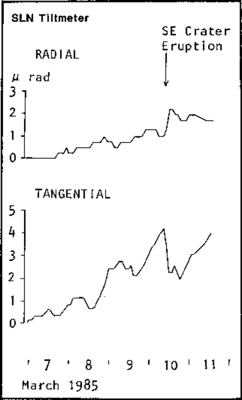 |
Figure 21. Small changes in tilt accompanying the Southeast Crater eruption, as recorded by the SLN tiltmeter, 7-11 March. |
Geological Summary. Mount Etna, towering above Catania on the island of Sicily, has one of the world's longest documented records of volcanism, dating back to 1500 BCE. Historical lava flows of basaltic composition cover much of the surface of this massive volcano, whose edifice is the highest and most voluminous in Italy. The Mongibello stratovolcano, truncated by several small calderas, was constructed during the late Pleistocene and Holocene over an older shield volcano. The most prominent morphological feature of Etna is the Valle del Bove, a 5 x 10 km caldera open to the east. Two styles of eruptive activity typically occur, sometimes simultaneously. Persistent explosive eruptions, sometimes with minor lava emissions, take place from one or more summit craters. Flank vents, typically with higher effusion rates, are less frequently active and originate from fissures that open progressively downward from near the summit (usually accompanied by Strombolian eruptions at the upper end). Cinder cones are commonly constructed over the vents of lower-flank lava flows. Lava flows extend to the foot of the volcano on all sides and have reached the sea over a broad area on the SE flank.
Information Contacts: R. Romano, IIV; C. Archambault and C. Pambrun, CNET/PIRPSEV; P. Blum, IPG/PIRPSEV; P. Briole, IIV/IPG/PIRPSEV; G. Kieffer, Centre de Recherches Volcanologiques, Clermont-Ferrand/PIRPSEV; J. Tanguy, PIRPSEV; La Stampa, Torino.