Report on Tokachidake (Japan) — June 1985
Scientific Event Alert Network Bulletin, vol. 10, no. 6 (June 1985)
Managing Editor: Lindsay McClelland.
Tokachidake (Japan) Hot water ejected; new 10-15 m fissure forms
Please cite this report as:
Global Volcanism Program, 1985. Report on Tokachidake (Japan) (McClelland, L., ed.). Scientific Event Alert Network Bulletin, 10:6. Smithsonian Institution. https://doi.org/10.5479/si.GVP.SEAN198506-285050
Tokachidake
Japan
43.418°N, 142.686°E; summit elev. 2077 m
All times are local (unless otherwise noted)
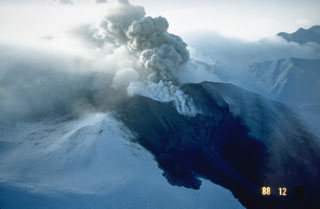
On the morning of 29 May, personnel of JMA's Tokachidake Volcano Observatory saw hot muddy water being ejected from a fumarole on the 1962 crater wall. The next day, they found that a 10-15-m fissure [or an elongated crater] had formed [on the wall of the 1962 crater]. Muddy water was continuously ejected from the fissure during their observations.
This activity stopped on 5 June. Thermal activity at the crater has been gradually increasing since 1983, although local seismic activity has remained at background levels.
Geological Summary. Tokachidake volcano consists of a group of dominantly andesitic stratovolcanoes and lava domes arranged on a NE-SW line above a plateau of welded Pleistocene tuffs in central Hokkaido. Numerous explosion craters and cinder cones are located on the upper flanks of the small stratovolcanoes, with the youngest Holocene centers located at the NW end of the chain. Frequent historical eruptions, consisting mostly of mild-to-moderate phreatic explosions, have been recorded since the mid-19th century. Two larger eruptions occurred in 1926 and 1962. Partial cone collapse of the western flank during the 1926 eruption produced a disastrous debris avalanche and mudflow.
Information Contacts: JMA, Tokyo.