Report on Sangeang Api (Indonesia) — October 1985

Scientific Event Alert Network Bulletin, vol. 10, no. 10 (October 1985)
Managing Editor: Lindsay McClelland.
Sangeang Api (Indonesia) Lava advance stops; fewer and smaller explosions
Please cite this report as:
Global Volcanism Program, 1985. Report on Sangeang Api (Indonesia) (McClelland, L., ed.). Scientific Event Alert Network Bulletin, 10:10. Smithsonian Institution. https://doi.org/10.5479/si.GVP.SEAN198510-264050
Sangeang Api
Indonesia
8.2°S, 119.07°E; summit elev. 1912 m
All times are local (unless otherwise noted)
"Sangeang Api entered into eruption on 30 July. The main features of the activity included an initial phase of mild Vulcanian explosions, followed by Strombolian explosions, a lava flow, and a persistent plume of water vapor and gas. The initial explosions on 30 July were accompanied by a small nuée ardente that followed the drainage of the Sori Kawangge 4 km down the SSW flank to ~200 m altitude, and produced a dark-colored, hornblende-bearing pumice. The eruption has continued through the first week of November but at a greatly reduced level from August. The frequency of explosions has declined steadily from ~150/day in early August to ~50/day in early September and fewer than 6/day in early November. The maximum height of the explosion cloud was ~1 km above the vent in August and
". . . The daily earthquake count shows a steadily decreasing trend, and in early November the number of earthquakes was less than 30/day. The lava flow, first observed on 6 August flowing W from the region of Doro Api crater (toward the village of Doro Sangeang), had advanced to about 4.7 km from the summit by 1 October. The flow showed no additional growth during October."
Photographs taken by astronauts from Space Shuttle mission 61A (30 October-5 November) showed a fairly dense plume extending roughly 50-100 km from Sangeang Api (figure 2).
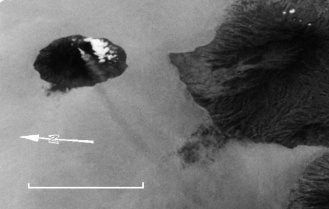 |
Figure 2. Space Shuttle photograph (no. 61A-40-062), taken 5 November 1985, showing a plume emerging from Sangeang Api, plus a portion of Sumbawa Island. Note that north is to the left. Courtesy of Charles A. Wood. |
Geological Summary. Sangeang Api volcano, one of the most active in the Lesser Sunda Islands, forms a small 13-km-wide island off the NE coast of Sumbawa Island. Two large trachybasaltic-to-tranchyandesitic volcanic cones, Doro Api and Doro Mantoi, were constructed in the center and on the eastern rim, respectively, of an older, largely obscured caldera. Flank vents occur on the south side of Doro Mantoi and near the northern coast. Intermittent eruptions have been recorded since 1512, most of them during in the 20th century.
Information Contacts: J. Matahelumual, Suparto S., and T. Casadevall, VSI; C. Wood, NASA.