Report on Colo (Indonesia) — October 1987
Scientific Event Alert Network Bulletin, vol. 12, no. 10 (October 1987)
Managing Editor: Lindsay McClelland.
Colo (Indonesia) 14 July plume may have been weather cloud
Please cite this report as:
Global Volcanism Program, 1987. Report on Colo (Indonesia) (McClelland, L., ed.). Scientific Event Alert Network Bulletin, 12:10. Smithsonian Institution. https://doi.org/10.5479/si.GVP.SEAN198710-266010
Colo
Indonesia
0.162°S, 121.601°E; summit elev. 404 m
All times are local (unless otherwise noted)
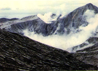
Although a NOAA 10 weather satellite image on 14 July showed a cloud that extended ~200 km from the vicinity of Una Una, no reports were received of an eruption from the island, uninhabited since residents were evacuated before the paroxysmal explosion of 23 July 1983.
Yosihiro Sawada inspected 14-15 July imagery from the GMS weather satellite. By 0800 on 14 July, less than an hour after the NOAA 10 image, the cloud retained a plume-like structure, but its origin was several tens of kilometers W of Una Una. An infrared image 24 hours later showed a chain of weather clouds extending SW from several sources just W of Una Una. On the image returned three hours later, these clouds had combined to form a plume-like feature similar to the one seen the previous day. This evidence, and the absence of a reported eruption, suggested that weather clouds may have produced the 14 July plume.
Geological Summary. Colo volcano forms the isolated small island of Una Una in the middle of the Gulf of Tomini in northern Sulawesi. The broad, low volcano contains a 2-km-wide caldera with a small central cone. Three eruptions have been recorded since the late 1800's, but two of those caused widespread damage over the island. The last eruption, in 1983, produced pyroclastic flows that swept over most of the island shortly after all residents had been evacuated.
Information Contacts: Y. Sawada, JMA.