Report on Taal (Philippines) — October 1987

Scientific Event Alert Network Bulletin, vol. 12, no. 10 (October 1987)
Managing Editor: Lindsay McClelland.
Taal (Philippines) Increase in recorded earthquakes; minor deformation
Please cite this report as:
Global Volcanism Program, 1987. Report on Taal (Philippines) (McClelland, L., ed.). Scientific Event Alert Network Bulletin, 12:10. Smithsonian Institution. https://doi.org/10.5479/si.GVP.SEAN198710-273070
Taal
Philippines
14.0106°N, 120.9975°E; summit elev. 311 m
All times are local (unless otherwise noted)
"Recorded earthquakes began increasing 30 October. A maximum of 19 events/day was recorded on 31 October; 5 of the events were felt by residents of Agoncillo, 10.7 km SW of the crater on the W shore of Taal Lake (figure 3). The events were recorded but not felt on the volcano island, the site of historic eruptions in the Taal Caldera. Some residents of Agoncillo also reported rumbling sounds accompanying the earthquakes. Isolated reports of sulfurous stench were unconfirmed. Many residents of Agoncillo and nearby villages described the quakes as having prominent vertical movements, similar to those prior to the 1965 eruption, prompting a few families to immediately evacuate to adjacent villages. These areas were among those devastated during the 1965 phreatic explosion.
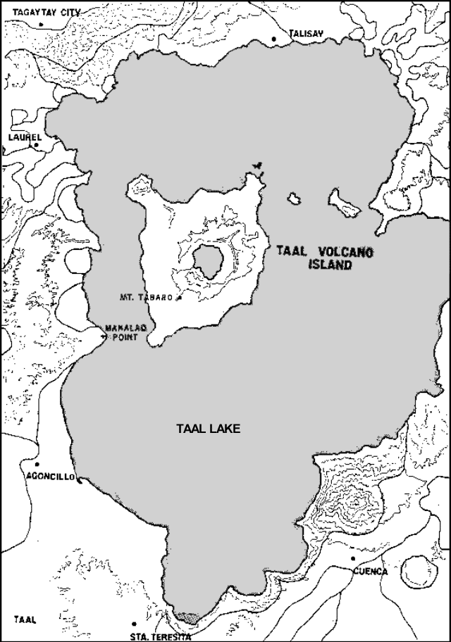 |
Figure 3. Map of crater lake and vicinity, after Land Use of Taal Volcano and Environs, PHIVOLCS, 1:50,000. |
"Events on 6 November had epicenters on Manalao Point on the W shore of Taal Lake and across the lake from the 1965-77 eruption site (Mt. Tabaro; figure 3). The earthquakes had depths of 6.4 km and suggested ground fracturing beneath the caldera.
"Thermal conditions and steam emissions of the main crater lake and the 1965-77 eruption site remained within normal levels. However, the water-tube tiltmeter on the island indicated a slight inflation-deflation episode of the main crater 20 April-28 October, with the pre-inflation position now being occupied. Likewise, thermal areas near the epicenter have remained unchanged. Lake-level monitoring stations around Taal Lake, some installed only last July, indicate some warping along the lakeshore, a condition that cannot yet be related to volcanic activity.
"PHIVOLCS had installed additional seismic and ground deformation stations to monitor the events. Local authorities were informed and were prepared for any contingencies."
Geological Summary. Taal is one of the most active volcanoes in the Philippines and has produced some powerful eruptions. The 15 x 20 km Talisay (Taal) caldera is largely filled by Lake Taal, whose 267 km2 surface lies only 3 m above sea level. The maximum depth of the lake is 160 m, with several submerged eruptive centers. The 5-km-wide Volcano Island in north-central Lake Taal is the location of all observed eruptions. The island is composed of coalescing small stratovolcanoes, tuff rings, and scoria cones. Powerful pyroclastic flows and surges have caused many fatalities.
Information Contacts: PHIVOLCS.