Report on Bezymianny (Russia) — October 1987
Scientific Event Alert Network Bulletin, vol. 12, no. 10 (October 1987)
Managing Editor: Lindsay McClelland.
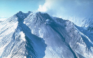
Bezymianny (Russia) Rockslide & fumarole activity; plume on NOAA 9 image
Please cite this report as:
Global Volcanism Program, 1987. Report on Bezymianny (Russia) (McClelland, L., ed.). Scientific Event Alert Network Bulletin, 12:10. Smithsonian Institution. https://doi.org/10.5479/si.GVP.SEAN198710-300250
Bezymianny
Russia
55.972°N, 160.595°E; summit elev. 2882 m
All times are local (unless otherwise noted)
Rockslides and fumarolic activity were observed 11-12 October and gas plumes with some ash reached 1 km height. A NOAA 9 satellite image returned at 0518 on 13 October showed a very thin, weak plume drifting 60-80 km NE.
Geological Summary. The modern Bezymianny, much smaller than its massive neighbors Kamen and Kliuchevskoi on the Kamchatka Peninsula, was formed about 4,700 years ago over a late-Pleistocene lava-dome complex and an edifice built about 11,000-7,000 years ago. Three periods of intensified activity have occurred during the past 3,000 years. The latest period, which was preceded by a 1,000-year quiescence, began with the dramatic 1955-56 eruption. This eruption, similar to that of St. Helens in 1980, produced a large open crater that was formed by collapse of the summit and an associated lateral blast. Subsequent episodic but ongoing lava-dome growth, accompanied by intermittent explosive activity and pyroclastic flows, has largely filled the 1956 crater.
Information Contacts: S. Fedotov and I. Menyailov, IV; W. Gould, NOAA/NESDIS.