Report on Banda Api (Indonesia) — May 1988
Scientific Event Alert Network Bulletin, vol. 13, no. 5 (May 1988)
Managing Editor: Lindsay McClelland.
Banda Api (Indonesia) Explosions and lava flows from several vents; three killed, 700 evacuated from two islands
Please cite this report as:
Global Volcanism Program, 1988. Report on Banda Api (Indonesia) (McClelland, L., ed.). Scientific Event Alert Network Bulletin, 13:5. Smithsonian Institution. https://doi.org/10.5479/si.GVP.SEAN198805-265090
Banda Api
Indonesia
4.523°S, 129.881°E; summit elev. 596 m
All times are local (unless otherwise noted)
Banda Api began to erupt on 9 May at 0630. Two simultaneous eruption columns rose 3-5 km, and three lava flows were extruded. Explosions and lava production continued through the day from craters on the N and S flanks, 1.2 km apart. The activity was more explosive on the S flank than on the N flank. At about 1130, the vertical eruption column from the S vent was briefly deflected to the S, thereby blasting or spraying tephra over a wide area of the western tip of Lontar Island (<1 km from the S end of Gunung Api Island). The duration of the directed blast was less than a minute, and eyewitnesses report that "the entire eruption column bent sideways to the S." This deflection was probably caused by slope failure above the vent. Material slumped into the vent and temporarily deflected the eruption column to the S.
A small volume of lava was erupted on the SSW flank at Pintu Kecil (mainly from a vent at 150-200 m elevation) and entered the sea along the S coast. About 50 m E of this flow, a small fissure opened at the coastline and produced a phreatomagmatic deposit of several hundred cubic meters. This deposit was being rapidly eroded when examined on 17 May. Two large lava flows emerged from two fissure craters ~ 400 m apart on the N and NW flanks (at Batu Angus and Pasir Besar). The lower crater was at ~ 150 m elevation, and the upper crater at ~ 200-250 m elevation. The flow at Batu Angus had entered the sea by 1100 on 9 May and continued through 15 May, although most of the volume had already entered by 10 May. The Pasir Besar flow reached the sea on 9 May. A graben developed between the two N-flank vents, causing the two craters to coalesce, probably by late in the day on 9 May. At 2300 on 9 May, activity at the S crater died, and several hours later activity at the N crater also declined.
On 10 May, the principal activity was from the summit crater, with minor lava outflow continuing from the N crater. Explosions continued from the summit crater 10-15 May but at gradually diminishing levels of activity. By 16 May, lava on the N side (Batu Angus) had ceased flowing, although occasional phreatic explosions were occurring where lava had covered the littoral zone and entered the sea. All craters were quiet by 18 May.
The first few minutes of the eruption produced a pumice lapilli of light gray to beige color with prominent dark euhedral phenocrysts of pyroxene. Material erupted later in the day was more scoriaceous and darker in color. Samples of the three 9 May lava flows are similar in hand specimen; dark gray to greasy black plagioclase pyroxene (hypersthene?) phyric lavas. No olivine has been positively identified in hand specimen.
Through 27 May, > 7,000 inhabitants from Gunung Api, Neira, and Lontar Islands have been evacuated to Ambon Island, 200 km NW of Banda Api. Three people were killed during the eruption, two in a boat mishap while evacuating the island.
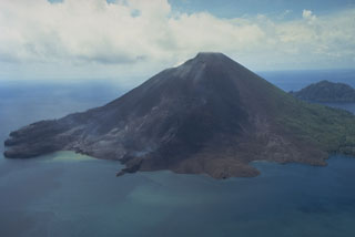
Geological Summary. The 3-km-wide island of Banda Api is the northern-most volcano in the Banda arc and has a long period of recorded observation because of its key location in the Portuguese and Dutch spice trade. The basaltic-to-rhyodacitic volcano is located in the SW corner of a mostly submerged 7 km caldera. At least two episodes of caldera formation are thought to have occurred, with the arcuate islands of Lonthor and Neira considered to be pre-caldera remnants. A conical peak rises to about 600 m at the center of the island. Eruptions have been recorded since 1586 CE, mostly consisting of Strombolian eruptions from the summit crater, but larger explosive eruptions have occurred and occasional lava flows have reached the coast.
Information Contacts: VSI.