Report on Kilauea (United States) — August 1988

Scientific Event Alert Network Bulletin, vol. 13, no. 8 (August 1988)
Managing Editor: Lindsay McClelland.
Kilauea (United States) Coastal lava benches build and collapse
Please cite this report as:
Global Volcanism Program, 1988. Report on Kilauea (United States) (McClelland, L., ed.). Scientific Event Alert Network Bulletin, 13:8. Smithsonian Institution. https://doi.org/10.5479/si.GVP.SEAN198808-332010
Kilauea
United States
19.421°N, 155.287°W; summit elev. 1222 m
All times are local (unless otherwise noted)
During August, lava continued to enter the ocean ~600 m E of Kupapau Point (figure 56). The collapse of lava benches into the sea . . . continued during August. Several lava benches collapsed during the month, the largest a 250 x 50 m bench that collapsed at 0614 on 15 August. On 17 August, "fountaining" was seen from two openings on the bench, ~10-15 m from the coast. This steam jetting and spattering was apparently caused by water entering a partially congealed submarine tube. Another bench collapse occurred on 27 August at 1000. The E tube system had no activity since the last week in July.
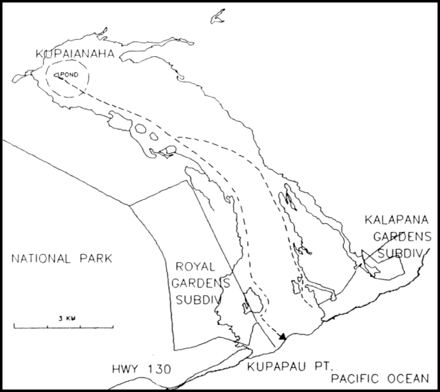 |
Figure 56. Map showing the lava flows from the Kupaianaha vent on Kīlauea's East rift zone. The dashed lines show the active tube system in August 1988. The arrow indicates the area where lava enters the ocean. |
Although new shoreline is being formed, the total area of new land is changing very little because lava is being added to previous collapse sites. Cones formed by small littoral explosions are washed away when collapses occur. Early shoreline extension was more rapid as lava flows covered tide pools and shallow shoreline, but flows have advanced onto a much steeper submarine slope and thus are unstable, causing frequent collapses.
Minor surface breakouts from the tube system occurred 1-11 August at ~72 m elevation on the E edge of the flow field, advancing ~150 m into forest. The lava pond level at the active (Kupaianaha) vent was 16-23 m below the rim through August. There was one sighting of activity at Pu`u `O`o on 2 August and incandescence was observed a few times when the vent was not obscured by fume. Rockfall debris covered most of Pu`u `O`o's crater floor.
Volcanic tremor continued at low level . . . near the eruptive site. Rockfall signals from Pu`u `O`o were frequent during the month. A second source of tremor related to flows entering the ocean was detected at Wahaula, 3 km away. Explosive collapses of oceanfront deposits were also recorded. Notable collapses occurred at 0615-0640 on 15 August, 0100-0130 on the 21st, 1000-1040 on the 27th and 0010-0030 on 31 August. The number of shallow microearthquakes was about average. A swarm of intermediate-depth long-period earthquakes occurred beneath the summit area in mid-August. Most of the earthquakes located during the month were concentrated in Kīlauea's S flank and in the Kaoiki region at intermediate depths of 5-15 km. There were scattered occurrences of earthquakes ~50 km W of Upolo Point on the N tip of the island. Intermittent earthquakes have occurred in this area since March.
Geological Summary. Kilauea overlaps the E flank of the massive Mauna Loa shield volcano in the island of Hawaii. Eruptions are prominent in Polynesian legends; written documentation since 1820 records frequent summit and flank lava flow eruptions interspersed with periods of long-term lava lake activity at Halemaumau crater in the summit caldera until 1924. The 3 x 5 km caldera was formed in several stages about 1,500 years ago and during the 18th century; eruptions have also originated from the lengthy East and Southwest rift zones, which extend to the ocean in both directions. About 90% of the surface of the basaltic shield volcano is formed of lava flows less than about 1,100 years old; 70% of the surface is younger than 600 years. The long-term eruption from the East rift zone between 1983 and 2018 produced lava flows covering more than 100 km2, destroyed hundreds of houses, and added new coastline.
Information Contacts: C. Heliker and R. Koyanagi, HVO.