Report on Tokachidake (Japan) — December 1988
Scientific Event Alert Network Bulletin, vol. 13, no. 12 (December 1988)
Managing Editor: Lindsay McClelland.
Tokachidake (Japan) Ash ejection; small pyroclastic flows and mudflow
Please cite this report as:
Global Volcanism Program, 1988. Report on Tokachidake (Japan) (McClelland, L., ed.). Scientific Event Alert Network Bulletin, 13:12. Smithsonian Institution. https://doi.org/10.5479/si.GVP.SEAN198812-285050
Tokachidake
Japan
43.418°N, 142.686°E; summit elev. 2077 m
All times are local (unless otherwise noted)
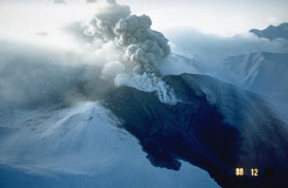
Tokachi-dake's first large eruption since 1962 followed more than two months of gradually increasing seismicity. The number of recorded earthquakes began to build in late September, totaling 43 in October and 93 in November compared to the typical background level of 10-20 events/month (figure 2). Stronger seismicity from 19 November was followed by emission of a 1,200-m white plume on the 22nd from crater 62-2, one of a line of vents formed during the 1962 eruption. Occasional episodes of volcanic tremor, the first in more than a year, had been recorded since 4 October and became more frequent in early December. Eruptive activity followed through most of December.
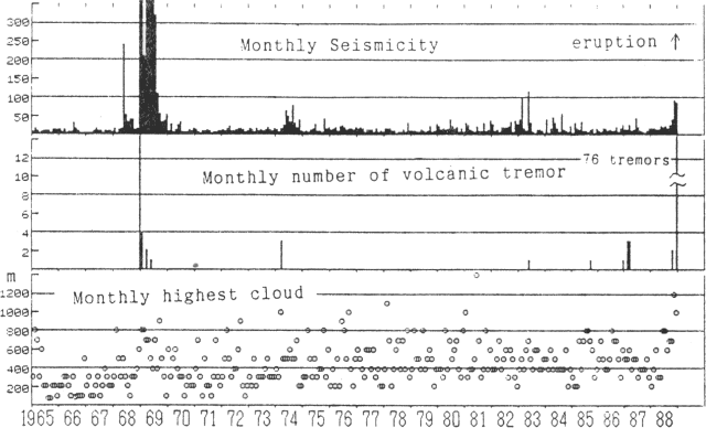 |
Figure 2. Monthly recorded earthquakes (top), number of volcanic tremor episodes (middle), and height of highest observed cloud (bottom) at Tokachi, 1965-88. Courtesy of JMA. |
Snow darkened by ash was first noticed on 5 December. A gray plume rose 200 m on 10 December and ash again fell near the crater. No gray plumes had been seen since 1962 from JMA's Tokachi-dake Observatory, [5.8] km NW of the crater, although bad weather has often prevented observation, especially in winter when the crater is only visible about once a week. Tremor episodes were more frequent after 11 December. Light gray to gray plumes were again observed 11-12 December. Darkened snow was seen from the air the morning of the 13th, extending ~1 km N from crater 62-2, and Observatory personnel saw a gray to dark gray plume emerging from the crater from about 1430 to 1600 that day.
A vigorous phreatic eruption from crater 62-2 began at roughly 0600 on 16 December. The eruption was preceded by an earthquake at 0524 that was felt at intensity III (JMA scale) in Fukiage, 3 km W of the crater. Volcanic tremor was recorded between 0603 and 0611 but weather clouds obscured the crater and the start time of the eruption remains uncertain. Ash began to fall at Ikeda, 80 km SE of the volcano, at around 0700. A similar sequence began on 18 December at 0838 with an earthquake felt in Fukiage at intensity I, followed by 21 minutes of volcanic tremor. Clouds again obscured the volcano, but ashfall began around 0900 at towns as much as 30 km E of the volcano.
An earthquake on 19 December at 2148 (intensity I in Fukiage) marked the onset of phreatomagmatic activity from crater 62-2 that was accompanied by a long period of high-amplitude volcanic tremor. People near the volcano saw an incandescent column and a dark volcanic cloud. A small mudflow, generated by snowmelt, moved ~600 m down the NW flank, reaching 1,400 m elevation. Yoshio Katsui noted that a pyroclastic surge had melted snow in an area of 500 x 800 m. Although the highest ash cloud seen from the Observatory reached only 300 m, ash reached Abashiri and Kitami on the NE coast of Hokkaido, 150 km from the volcano. Weak volcanic tremor continued intermittently the next day and a light gray to gray plume was rising 200-400 m during the morning. Slight ashfalls were reported to 35 km from the volcano on the 21st and to 15 km 22-23 December. Periods of volcanic tremor continued.
A larger phreatomagmatic eruptive episode began at 2212 on 24 December, accompanied by an earthquake. An incandescent column rose 200 m and the 1-km ash cloud contained lightning. A pyroclastic flow advanced 1 km NW but there was no mud flow and no property was damaged. At 2232, the mayor of Kami-Furano instructed residents of 3 inhabited areas within 15 km W of the crater to evacuate; 2 minutes later, the evacuation of the Shirogane area, 6 km NW, was requested by the mayor of Biei. Population of the four affected areas is about 800. Vigorous eruption resumed at 0049, feeding similar columns of ash and incandescent tephra. JMA Observatory personnel saw a glowing flow descend to the NW. Volcanic tremor was recorded 0049-0315 and 0332-0340. Tremor and emission of a gray plume continued intermittently during the day. Ashfalls extended 80 km SE. A morning overflight revealed a somewhat enlarged 62-2 crater, but other craters and fumarolic areas appeared unchanged. Fieldwork by Katsui and others documented a pyroclastic flow 1 km long with a maximum temperature of 92°C at 50 cm depth, 60 hours after the eruption.
An earthquake at 0527 on 30 December, felt at intensity 1 at Fukiage, marked renewed eruptive activity. Weather clouds prevented observations but ash fell 30 km SE. Evacuation of the Kami-Furano area was cancelled 31 December, but was continued for Shirogane residents. Red glow and ejection of a black cloud were observed from the JMA Observatory on 1 January at 0212. The eruption seemed small and only nearby ashfalls were reported.
Activity resumed briefly on 8 January at 1938. An incandescent column was seen for a short time but weather obscured the volcano from JMA Observatory staff. Ash fell on towns to a few tens of kilometers SW of the volcano but no damage was reported. An earthquake was recorded at the beginning of the 8 January activity, probably an explosion shock of the type common in earlier explosive episodes. Volcanic tremor followed for about 10 minutes, and geologists presumed that the eruption ended as tremor ceased.
Of the three types of JMA official volcano information releases, the most serious (Volcanic Activity Information) is issued when volcanism is considered to be dangerous to people. VAI releases appeared three times during the eruption, all during the 24-25 December activity, while Extra Volcano Information reports were produced 23 times in November and December for activity judged less hazardous.
Geological Summary. Tokachidake volcano consists of a group of dominantly andesitic stratovolcanoes and lava domes arranged on a NE-SW line above a plateau of welded Pleistocene tuffs in central Hokkaido. Numerous explosion craters and cinder cones are located on the upper flanks of the small stratovolcanoes, with the youngest Holocene centers located at the NW end of the chain. Frequent historical eruptions, consisting mostly of mild-to-moderate phreatic explosions, have been recorded since the mid-19th century. Two larger eruptions occurred in 1926 and 1962. Partial cone collapse of the western flank during the 1926 eruption produced a disastrous debris avalanche and mudflow.
Information Contacts: JMA.