Report on Kick 'em Jenny (Grenada) — December 1988
Scientific Event Alert Network Bulletin, vol. 13, no. 12 (December 1988)
Managing Editor: Lindsay McClelland.
Kick 'em Jenny (Grenada) Seismicity suggests submarine eruption
Please cite this report as:
Global Volcanism Program, 1988. Report on Kick 'em Jenny (Grenada) (McClelland, L., ed.). Scientific Event Alert Network Bulletin, 13:12. Smithsonian Institution. https://doi.org/10.5479/si.GVP.SEAN198812-360160
Kick 'em Jenny
Grenada
12.3°N, 61.64°W; summit elev. -185 m
All times are local (unless otherwise noted)
"Seismographs throughout the eastern Caribbean recorded strong underwater acoustic signals 29-30 December 1988. The first signals began at approximately 1550 on 29 December. Onset of the signals was extremely emergent, so their point of origin could not be determined precisely, but their pattern of arrivals and amplitudes suggested an origin in the southern Lesser Antilles. The most likely source was thought to be Kick-'em-Jenny.... When last surveyed in 1982, the summit of this volcano was 160 m below sea level. The initial signals persisted for approximately 56 minutes.
"A shorter but more intense signal was recorded on the 29th between 1722 and 1750. At this time, residents of Sauteurs on the N coast of Grenada felt strong ground vibrations and heard a deep rumbling sound. Although observers in full view of the location of the volcano had been alerted by this time, no disturbance of the sea surface was noted. Vibrations were felt and heard as far away as Martinique, 250 km to the N. Georges Boudon from the Martinique volcano observatory was scuba diving off the N coast of Martinique at the time and distinctly heard the underwater signal.
"A third explosion occurred at about 0500 on 30 December. Onsets for this event were much more distinct and it was confirmed that Kick-'em-Jenny was the source. Lt. Col. Glen Mignon of the Grenada Defence Force surveyed the site from a vessel of the Grenada Coast Guard on the morning of 30 December but no disturbance of the sea surface was visible [but see 14:5]. No further explosions have been recorded as of 2 January but as a precautionary measure small vessels have been advised to keep 5 km clear of the volcano until further notice."
References. Shepherd, J.B., and Robson, G.R., 1967, The source of the T-phase recorded in the eastern Caribbean on October 24, 1965: Bulletin of the Seismological Society of America, v. 57, p. 227-234.
Sigurdsson, H. and Shepherd, J.B., 1974, Amphibole-bearing basalts from the submarine volcano Kick-'em-Jenny in the Lesser Antilles Island Arc: BV, v. 38, p. 891-910.
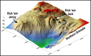
Geological Summary. Kick 'em Jenny, an active submarine volcano 8 km off the N shore of Grenada, rises 1,300 m from the sea floor. Recent bathymetric surveys have shown evidence for a major arcuate collapse structure, which was the source of a submarine debris avalanche that traveled more than 15 km W. Bathymetry also revealed another submarine cone to the SE, Kick 'em Jack, and submarine lava domes to its S. These and subaerial tuff rings and lava flows at Ile de Caille and other nearby islands may represent a single large volcanic complex. Numerous eruptions have occurred since 1939, mostly documented by acoustic signals. Prior to the 1939 eruption, when an eruption cloud rose 275 m above the ocean and was witnessed by a large number of people in northern Grenada, there had been no written mention of the volcano. Eruptions have involved both explosive activity and the quiet extrusion of lava flows and lava domes in the summit crater; deep rumbling noises have sometimes been heard onshore. Recent eruptions have modified the morphology of the summit crater.
Information Contacts: J. Shepherd, UWI; Lt. Col. G. Mignon, Grenada; C. Antenor-Habezac, Observatoire Volcanologique de la Guadeloupe.