Report on Concepcion (Nicaragua) — April 1989
Scientific Event Alert Network Bulletin, vol. 14, no. 4 (April 1989)
Managing Editor: Lindsay McClelland.
Concepcion (Nicaragua) Strong fuming
Please cite this report as:
Global Volcanism Program, 1989. Report on Concepcion (Nicaragua) (McClelland, L., ed.). Scientific Event Alert Network Bulletin, 14:4. Smithsonian Institution. https://doi.org/10.5479/si.GVP.SEAN198904-344120
Concepcion
Nicaragua
11.538°N, 85.622°W; summit elev. 1700 m
All times are local (unless otherwise noted)
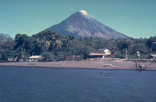
During fieldwork 24 March, fuming obscured the interior of the summit crater. Most of the gas appeared to originate below a step in the crater's inner NE wall. A zone of weak fumaroles about 30 m below the rim on the inner E crater wall had a maximum surface temperature of 42°C (measured by an 8-14 micrometer bandpass infrared thermometer from a distance of about 300 m), suggesting gas temperatures of around 100°C.
Geological Summary. Volcán Concepción is one of Nicaragua's highest and most active volcanoes. The symmetrical basaltic-to-dacitic stratovolcano forms the NW half of the dumbbell-shaped island of Ometepe in Lake Nicaragua and is connected to neighboring Madera volcano by a narrow isthmus. A steep-walled summit crater is 250 m deep and has a higher western rim. N-S-trending fractures on the flanks have produced chains of spatter cones, cinder cones, lava domes, and maars located on the NW, NE, SE, and southern sides extending in some cases down to Lake Nicaragua. Concepción was constructed above a basement of lake sediments, and the modern cone grew above a largely buried caldera, a small remnant of which forms a break in slope about halfway up the N flank. Frequent explosive eruptions during the past half century have increased the height of the summit significantly above that shown on current topographic maps and have kept the upper part of the volcano unvegetated.
Information Contacts: C. Oppenheimer, Open Univ.