Report on Poas (Costa Rica) — April 1989
Scientific Event Alert Network Bulletin, vol. 14, no. 4 (April 1989)
Managing Editor: Lindsay McClelland.
Poas (Costa Rica) Crater lake gone; explosions and molten sulfur ponds
Please cite this report as:
Global Volcanism Program, 1989. Report on Poas (Costa Rica) (McClelland, L., ed.). Scientific Event Alert Network Bulletin, 14:4. Smithsonian Institution. https://doi.org/10.5479/si.GVP.SEAN198904-345040
Poas
Costa Rica
10.2°N, 84.233°W; summit elev. 2697 m
All times are local (unless otherwise noted)
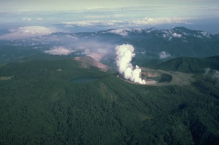
Until mid-April, thermal activity remained similar to that observed in March, with boiling mud springs and vigorous fumaroles in the crater lake, which has been shrinking since early 1987. Two ponds of molten sulfur (115°C) have persisted since 16 March at the former site of small sulfur and mud cones 50 m SE of the center of the inner crater (figure 14). Small pyroclastic sulfur cones surrounded the lakes, collapsing occasionally.
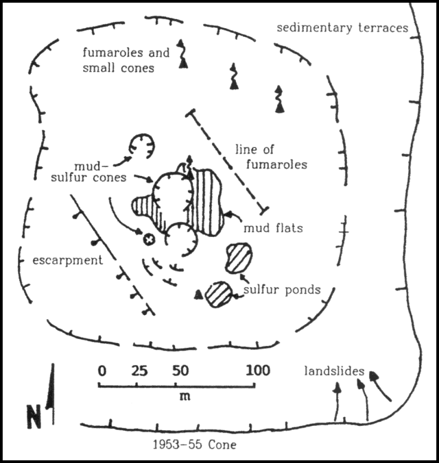 |
Figure 14. Sketch map of the inner crater at Poás and its features, April 1989. Courtesy of Gerardo Soto. |
On 12 April, the crater lake was convecting vigorously, but shallow areas were visible. The lake level dropped about 2 m during the following week, and by 19 April only a few small mud pools remained. The characteristic geyser-type phreatic activity through the crater lake changed 18-19 April with the lake's near disappearance. Cypressoid vertical columns continuously rose about 25 m above the former center of the lake and began to build a mud/pyroclastic cone. On 19 April, small bursts of gas and mud that contained sulfur particles emerged through the mud surface to heights of about 10 m, rarely to 25-30 m. Steaming was continuous. Activity had increased slightly the next day, but magnetometer traverses that passed about 100 m from the active area showed no changes since the last measurements on 3 April. Phreatic bursts reached about 50 m height on 21 April. Using a thermocouple, Jorge Barquero measured a liquid temperature of 116°C in one of the sulfur ponds. On 22 April at around 1000, a dark mushroom-shaped column developed, convecting to 200-300 m height. Fine mud, sulfur, and burning gases (possibly hydrogen) were ejected until 1032. Fine yellow material fell on the W side of the inner crater [see also 14:05]. Ejection of lithic material stopped suddenly and the plume reverted to its normal white color. About 15 minutes later, continuous geysering of dark sediment and gas was observed for 2-3 minutes. Clouds obscured the summit at 1130. At 2100, after weather had cleared, the base of the plume was suddenly illuminated by a pink-orange light for about 2 minutes. No sounds were audible other than those accompanying the continuing phreatic activity. The light stopped suddenly and was thought to have been generated by burning gases.
During observations on 23 April, a thick white plume coalesced from numerous vents, two of which were discharging a mixture of white condensed steam and yellow sulfur. Dark cypressoid plumes were emitted every few seconds. At least one vent continuously discharged fine dark material. At 0717, a pink-orange light was again seen at the base of a continuous white plume on the SW side of the crater bottom. The light remained visible for 2.5 minutes, and geologists believed that it was generated by burning gases. A brightness temperature of 158°C was recorded (with an 8-14 micrometer bandpass infrared thermometer), but the measurement was made from almost 1 km distance and geologists suspected that the temperature was probably several hundred degrees higher. Phreatic activity from at least six of the vents expelled blocks to about 50 m height and occasionally to 100 m or more, generally vertically but sometimes obliquely. Most of the ejecta fell within 10-20 m of the vents, building cones to about 10 m height with funnel-shaped craters up to 5 m in diameter. The ejecta appeared dry and included blocks more than 20 cm across. Radiant temperatures of dark plumes were only about 80°C as measured from about 150 m away. Activity occasionally reached a level at which at least one of the six or more phreatic vents was erupting at a given time. Booming noises and sounds like a jet engine were occasionally heard. From nearer the vents, sounds like pistol shots were audible.
The two ponds of dark brown, very fluid, bubbling liquid, apparently sulfur, were about 50 cm below the former crater lake floor in steep-sided pits. One, roughly elliptical, was about 20 m across, while the other was dumbbell-shaped and about 10 m long. A terrace of solid sulfur had developed at the edge of the liquid, and the sides and rims of the pits were coated by bright yellow sulfur sublimates. A moderate amount of visible condensate rose from their surfaces and the smell of SO2 was strong. No surface burning was evident. Blocks of pale-colored altered rock (probably former lake sediments) floated on the sulfur ponds, suggesting a density substantially above 1 g/cm3. Remnants of the former crater lake had a maximum surface infrared radiometer temperature of 97°C.
Four geologists (G. Alvarado, M. Fernández, G. Soto, and D. Stevenson) descended to the bottom of the inner crater on 25 April. The activity had built at least three new cones, aligned with the sulfur ponds along a N30°W trend. The cones, 10-12 m high, were continuously active, emitting vertical columns of mud, sulfur, gases, and rocks to 30-70 m (occasionally 100 m) height for some seconds. Optical radiometer temperatures of the plumes were 75-90°C. Lesser thermal features (fumaroles, small hot lakes, and boiling mud springs) were found around the periphery of the cones. A small fault scarp, parallel to the line of cones, cut the sediments. The faulting was interpreted as the result of subsidence caused by the removal of the eruptive products, and a decrease in the internal pore pressure of the subsurface hydrothermal regime. At noon, the geologists were surprised by (but escaped unscathed from) a sudden eruption of sulfur, mud, and gases (some burning) that formed a thick vertical column nearly 400 m high, with a minimum radiometer temperature of 459°C. Sulfur and mud fell on the W wall of the crater and over the rim (toward Cerro Pelón). Other similar eruptions deposited greenish-gray mud within the crater.
The column from a larger eruption on 28 April between 0500 and 0600 reached an estimated height of 1.5-2 km and dropped fine mud to 2.5 km S of the source [see also 14:05]. The next day, the central mud cone (which had reached about 20 m height) ejected vertical columns of mud and sulfur to 200 m height. The small SW mud cone was in nearly continuous activity, emitting brown-gray lithic ash that was carried W by the wind. The gases were sulfurous, strongly yellow- and orange-colored, and rose in a vertical convective column to 350 m height. Eruptive characteristics were similar on 30 April and 1 May, but with columns to 1-1.5 km high on the 1st. The wind carried the fine lithic ash and mud toward the W onto various towns (including Bajos de Toro, Zarcero, and Sarchí).
Activity decreased 2 and 3 May. On the 3rd, ash was measured on the crater rim, reaching 1 mm thickness at point A (figure 15) and 2 mm at point B. Particles reached medium-grained ash size and were lithic, dominantly mud/clay granules of sulfide/sulfate sediments with a high percentage of solutes.
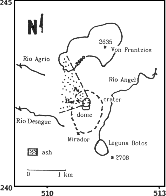 |
Figure 15. Distribution of ash at Poás, and sites where thicknesses were measured 3 May 1989. Sketch and data from G. Soto. |
Seismicity has visibly declined. Volcanic earthquakes totaled 4,240 in April, for a mean of 141/day (figure 16). Seismicity continued to be dominated by B-type events, although their number had decreased. The most significant change was the appearance of tremor episodes with durations of 4-10 minutes. The change in seismic pattern was interpreted by Morales et al. (1988) as the change from magma-water interaction in a medium that is not open (B-type signals) to one that is partially open (continuous train of B-type signals or tremors).
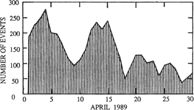 |
Figure 16. Number of seismic events recorded/day at Poás by the Red Sismológica Nacional, April 1989. Courtesy of Mario Fernández. |
Reference. Morales, L.D., Soley, J.F., Alvarado, G.E., Borgia, A., and Soto, G., 1988, análisise espectral de algunas señales sísmicas y su relación con la actividad de los volcanes Arenal y Poás, Costa Rica: Boletín del Observatorio Vulcanológico del Arenal, año 1, no. 2, p. 1-25.
Geological Summary. The broad vegetated edifice of Poás, one of the most active volcanoes of Costa Rica, contains three craters along a N-S line. The frequently visited multi-hued summit crater lakes of the basaltic-to-dacitic volcano are easily accessible by vehicle from the nearby capital city of San José. A N-S-trending fissure cutting the complex stratovolcano extends to the lower N flank, where it has produced the Congo stratovolcano and several lake-filled maars. The southernmost of the two summit crater lakes, Botos, last erupted about 7,500 years ago. The more prominent geothermally heated northern lake, Laguna Caliente, is one of the world's most acidic natural lakes, with a pH of near zero. It has been the site of frequent phreatic and phreatomagmatic eruptions since an eruption was reported in 1828. Eruptions often include geyser-like ejections of crater-lake water.
Information Contacts: G. Soto, Mario Fernández, and Héctor Flores, UCR; Guillermo Alvarado, R. Barquero, and Ileana Boschini, ICE; David Stevenson and C.M.M. Oppenheimer, Open Univ.