Report on Redoubt (United States) — November 1989
Scientific Event Alert Network Bulletin, vol. 14, no. 11 (November 1989)
Managing Editor: Lindsay McClelland.
Redoubt (United States) Repeated strong explosions eject large tephra clouds
Please cite this report as:
Global Volcanism Program, 1989. Report on Redoubt (United States) (McClelland, L., ed.). Scientific Event Alert Network Bulletin, 14:11. Smithsonian Institution. https://doi.org/10.5479/si.GVP.SEAN198911-313030
Redoubt
United States
60.485°N, 152.742°W; summit elev. 3108 m
All times are local (unless otherwise noted)
A series of strong explosions began 14 December after about a day of vigorous seismicity. Eruption clouds reached 12 km altitude, and airline pilots later reported ash layers in the atmosphere as far as S Texas (5,000 km from the volcano). Despite warnings from aviation authorities, several aircraft encountered the ash, and one, with 245 persons on board, lost power to all of its engines for 8 minutes before restarting and landing safely. The area immediately around the volcano is thinly populated, but the potential for eruption-induced flooding threatened an oil storage facility and forced the evacuation of most of its personnel. Redoubt was last active from early 1966 until mid-1968, with periods of repeated explosive episodes separated by as much as 8 months of quiet.
Pre-eruption seismicity and warnings. An increase in local seismicity to slightly above background level was first noticed 8 December on AVO's five-station seismic array. At about the same time, an apparent flank steam plume was observed from Anchorage, roughly 200 km NE of Redoubt. Seismicity increased somewhat during the morning of 13 December, and more strongly at about 1100 (to about 1-2 low-frequency microearthquakes/minute). AVO notified the Governor's Office, the Alaska Division of Emergency Services, the FAA, and the Drift River oil storage facility (figure 1) of the increased seismicity and expressed concern about (but did not formally forecast) an eruption. AVO's press release, issued at 1600, described the seismicity and noted that "It is impossible to state at this time whether the seismic activity is a precursor to a volcanic eruption, but that is a possibility of some concern." Steps were taken to reduce risk to the Drift River facility (including making oil storage tanks neutrally buoyant) and the FAA issued a warning of possible ash hazard.
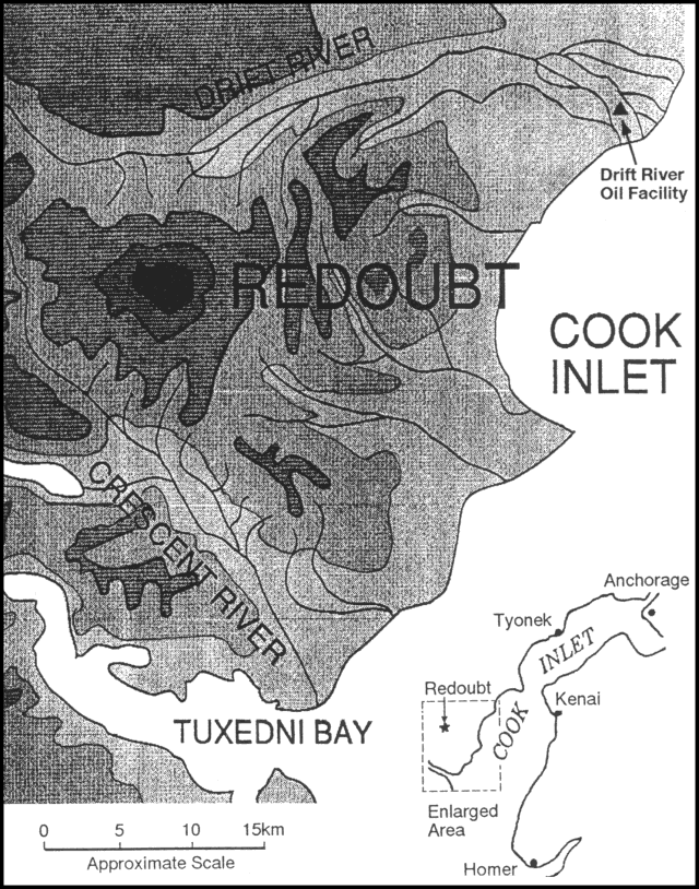 |
Figure 1. Sketch map of Redoubt and vicinity. Contour interval is 2,000 feet, about 600 m. Shading darkens with each 2000-foot interval. Courtesy of AVO. |
Eruption onset, 14 December. About 0700 the next morning, seismic amplitudes on flank instruments decreased slightly, while slightly increased amplitudes were recorded at the summit. At about the same time, a magnitude 4 tectonic earthquake occurred at 80-95 km depth about 40 km S of Redoubt. Strong tremor began at about 1013, indicating the onset of the eruption. Five minutes later a MarkAir pilot reported that an ash column had reached 10.5 km altitude. Winds carried ash NE, with light dustings reported N and W of Anchorage. Within an hour, satellite images showed a plume that extended 156 km from the volcano and was as much as 90 km wide. The cloud top temperature determined from satellite data was about -47°C. Radiosonde data from Anchorage showed a similar temperature at about 9 km altitude. Jet stream winds at that altitude were blowing almost due N (from 190°) at 110-165 km/hour. At 1156, the FAA issued a Notice to Airmen (NOTAM), imposing temporary flight restrictions in the area.
During an overflight by AVO geologists that afternoon, steam was rhythmically pulsing from an upper N flank crater, in the same general area as the source of Redoubt's 1966-68 eruption. No ash was visible on the flanks. A helicopter overflight by oil facility personnel revealed evidence that about 15 m of flooding had occurred in the upper Drift River and that the flood was about 12 m high in the lower valley, a few vertical meters from facility equipment (but see 18 December overflight data). Some steaming boulders were observed in the flood debris.
That evening, two bursts of seismicity, each lasting about an hour, occurred between 1915 and 2245. The activity was not recorded at the Spurr station, 60 km N of Redoubt, and was not associated with any reported ash emission.
Large explosions and aircraft encounter with tephra cloud, 15 December. A sharp seismic pulse, about 1 hour long, was recorded 15 December at 0140. At 0330, satellite data showed an apparent eruption cloud temperature of -30°C, corresponding to an altitude of 6-6.5 km. Between 0300 and 0400, satellite images showed plume movement toward 150° at 66 km/hour, with its leading edge 146 km from Redoubt by 0400. A second sharp seismic pulse, again lasting about 1 hour, began at 0338, but weather clouds obscured satellite observations. An airplane pilot reported that the ash cloud extended from Redoubt to Talkeetna (about 250 km NE of the volcano). Both seismic episodes were slightly stronger than that associated with the previous day's eruptive episode, and were recorded at the Spurr station. As of 0900, the near-summit seismic station showed continuing moderately strong seismic noise, possibly associated with vigorous steaming or continuing minor ash emission.
A powerful explosive episode that ejected a large tephra column was marked by a vigorous pulse of seismicity between about 1017 and 1100 that was the most energetic of the eruption thus far. Airplane pilots reported ash to at least 12 km altitude. A temperature of -45°C was measured in the thickest part of the cloud using satellite data at 1030, but the plume was at the edge of the image, calibration was difficult, and no height estimate was made. Ashfalls from the plume were reported N of the Alaska Range and E to Canada.
At 1150, a Boeing 747 jetliner with 231 passengers and 14 crew members encountered the plume at 7.5 km altitude near Talkeetna, about 150 km N of Anchorage. The KLM flight, bound from Amsterdam to Tokyo with a stop at Anchorage, lost power to all 4 engines and descended 4 km before restarting at 1158 and landing safely in Anchorage at 1225. Investigations of the incident continue. Several other, less serious contacts with the plumes by aircraft included a MarkAir Boeing 737 that reportedly required replacement of 2 engines and its windshield.
Earthquake activity declined after 1100 for about 8 hours, but remained above previous background levels. Renewed eruptive activity began at about 1900 with continuous ash eruption and sustained high levels of seismicity. Eruption clouds reached about 8.5 km altitude. During the night, satellite images showed a moderate plume, moving about 60 km/hour ESE at about 4.5 km altitude. [See 14:12 for petrographic data and information from reconnaissance studies of avalanche and lahar deposits].
Sustained eruptive activity, 16-19 December. Another strong eruptive pulse was recorded on 16 December at 0620. Pilots reported ash to 9-10.5 km altitude over and W of Anchorage, and by 0900 satellite images showed a plume as much as 160 km wide with its front 660 km ESE of the volcano.
Most of the activity 16-18 December was characterized by apparently continuous low-level ash emission, generally to less than 5 km altitude, occasionally punctuated by explosions that ejected ash to 7.5-9 km. Pilots reported an eruption 17 December at 1300, with ash reaching 8.5 km altitude. Seismicity increased after 0300 on 18 December and plumes rose to 6-9 km altitude. Another eruptive pulse occurred at 0830. Pilots reported plumes at 0910 and 1037 to 6 and 5 km altitudes respectively. At 1430, Redoubt's plume was about 150 km long and its satellite-derived temperature of -22°C suggested an elevation of about 6.5 km. Another moderate eruptive pulse was seen on satellite images beginning at 1530; 30 minutes later, the plume extended 40 km to the E.
AVO geologists flew over the volcano between 1240 and 1300 on 18 December. Vigorous white to gray steam clouds, some with ash and/or rock debris, rose to 6 km before moving NE. Tephra separated from the column at low altitude and was carried SE by light winds. Eruption columns emerged from a single large vent in the summit crater at roughly 2,400-2,550 m elevation; no other active vents were evident. A curtain of steam rose from the glacier-filled valley extending N from the crater, down to ~1,350 m, and individual steam plumes were evident down the valley to 750 m elevation. The source of the steam was apparently hot water from the vent area. Flooding in the Drift River appeared to be confined to its channel.
Satellite data 19 December at 0635 showed the start of another moderately large eruptive pulse. By 0700, it extended 65 km with a maximum width of 23 km. A plume temperature of -32°C indicated a height of <=5.5 km. Another eruptive episode at 0750 had a smaller seismic trace but a pilot reported a rising ash cloud at 9 km altitude. Imagery at 1230 showed no evidence of large new eruptions, but thick low-level plumes were moving WNW, W, and WSW to 70 km from the volcano. Cloud top temperatures of -22° to -25°C suggested altitudes of 4-5 km. More diffuse plumes extended to 200 km.
During an AVO overflight between 1240 and 1330, geologists observed billowing ash at the base of a sustained steam column that rose to <5 km. The strongest plume observed by the geologists reached 5.1 km altitude at 1245. A thin, ash-free yellowish fume layer at 5 km had an SO2 odor. Seismic records during the overflight indicated continuous low-level venting. Satellite data showed additional minor eruptions at 1400 and 1630, both with cloud top temperatures of -25°C, equivalent to about 4-5 km altitude.
Emission of steam but no ash was reported 20 December. Pilots in the area reported strong sulfur smells but no ash layers.
Distant cloud observations. By 16 December, pilots were reporting ash over the NW conterminous United States. Ash clouds were reported from as far as El Paso, Texas, 5000 km from the volcano, by 19 December. Data from the TOMS instrument on the Nimbus-7 satellite showed strong SO2 signals over W Nevada and nearby areas of S California at about noon on 16 December (figure 2). Only very minor possible SO2 enhancements off the coast of Baja California were evident during the satellite's next pass 24 hours later. Detection of SO2 near the volcano was not possible because of low seasonal sun angles. Data from earlier in the eruption were not immediately available.
 |
Figure 2. Preliminary data from the TOMS instrument on the Nimbus-7 polar orbiting satellite, on 16 December at about local noon. Each character represents the average SO2 value within an area about 60 km across. 0 = 12-16 milliatmosphere-cm (120-160 ppm-meters), 1 = 17-21 matm-cm (170-210 ppm-m), etc., increasing by increments of 5 matm-cm. 9 is followed by A, B, C, etc. Courtesy of Scott Doiron. |
Hazard mitigation efforts. In an effort to prevent aircraft encounters with volcanic clouds, NOAA and the FAA had recently concluded a formal agreement providing for detailed 24-hour monitoring of plumes by satellite specialists at SAB and forecasts of likely plume movement by NOAA's Air Resources Laboratory in support of the FAA's air safety and traffic flow responsibilities. The procedures outlined in the agreement, operating for the first time during the Redoubt eruption, yielded numerous detailed plume descriptions that prompted the issuance of frequent specific NOTAMs by the FAA. However, no air routes were formally closed. Since the onset of activity, AVO has immediately forwarded eruption data to the FAA, the Drift River oil facility, and other organizations with hazard responsibilities.
The Drift River oil facility, with a capacity of about a million barrels, serves oil platforms in the Cook Inlet. As the eruption began, 7 of its staff of 11 were evacuated, but operations, including loading of tankers, were not halted until 20 December. A shutdown of more than a few days would force production cutoffs of at least some of the Cook Inlet platforms. The facility had not been built at the time of the 1966-68 eruption, and the effects of that eruption on the facility site are not known to us.
Airline operations in Alaska were substantially reduced after the 15 December KLM incident, although some flights continued to and from Anchorage. With diminished activity 20 December, many airlines resumed at least partial service, and many of the passengers stranded by the activity were able to reach their destinations. Few people live near the volcano, but one family was evacuated from a lodge about 15 km S of the volcano. Despite occasional tephra falls, a family living at another lodge about 27 km N of the volcano elected to remain.
[Original Bulletin reports listed as Information Contacts many AVO scientists who provided news from Redoubt, but space precluded recognition of many others from AVO who made valuable contributions to the study of the eruption and mitigation of its hazards. At AVO's request, we therefore cite the "AVO Staff" for each Redoubt report.]
Geological Summary. Redoubt is a glacier-covered stratovolcano with a breached summit crater in Lake Clark National Park about 170 km SW of Anchorage. Next to Mount Spurr, Redoubt has been the most active Holocene volcano in the upper Cook Inlet. The volcano was constructed beginning about 890,000 years ago over Mesozoic granitic rocks of the Alaska-Aleutian Range batholith. Collapse of the summit 13,000-10,500 years ago produced a major debris avalanche that reached Cook Inlet. Holocene activity has included the emplacement of a large debris avalanche and clay-rich lahars that dammed Lake Crescent on the south side and reached Cook Inlet about 3,500 years ago. Eruptions during the past few centuries have affected only the Drift River drainage on the north. Historical eruptions have originated from a vent at the north end of the 1.8-km-wide breached summit crater. The 1989-90 eruption had severe economic impact on the Cook Inlet region and affected air traffic far beyond the volcano.
Information Contacts: AVO Staff; C. Newhall, USGS, Reston; S. Kusselson, G. Swanson, O. Karst, and M. Ruminsky, NOAA/NESDIS; S. Doiron, NASA GSFC; N. Krull, FAA; E. Miller, Air Line Pilots Association; AP; UPI; Reuters.