Report on Long Valley (United States) — November 1989

Scientific Event Alert Network Bulletin, vol. 14, no. 11 (November 1989)
Managing Editor: Lindsay McClelland.
Long Valley (United States) Seismic swarm gradually declines; minor inflation
Please cite this report as:
Global Volcanism Program, 1989. Report on Long Valley (United States) (McClelland, L., ed.). Scientific Event Alert Network Bulletin, 14:11. Smithsonian Institution. https://doi.org/10.5479/si.GVP.SEAN198911-323822
Long Valley
United States
37.7°N, 118.87°W; summit elev. 3390 m
All times are local (unless otherwise noted)
The seismic swarm...continued in October and November (figure 10). The number of earthquakes has slowly declined, from 220 in September to 137 in October and 52 in the first half of November. By 15 November, 1,564 swarm events had been recorded by the California Division of Mines and Geology NEWT system. There was no indication of any systematic depth migration during October or November. A USGS seismic station (MMP) in the epicentral area continued to record about a dozen to several dozen small (M<0.5) events/day through mid-December. Ten low-frequency events occurred in Octoer, for a total of 31 since the swarm began. Locations were similar to those of other swarm events, but the low-frequency shocks had emergent P-waves, lacked clear S-waves, and were of lower overall frequency than others of the same magnitude. Spasmodic tremor has occasionally been recorded, but only one episode occurred in October.
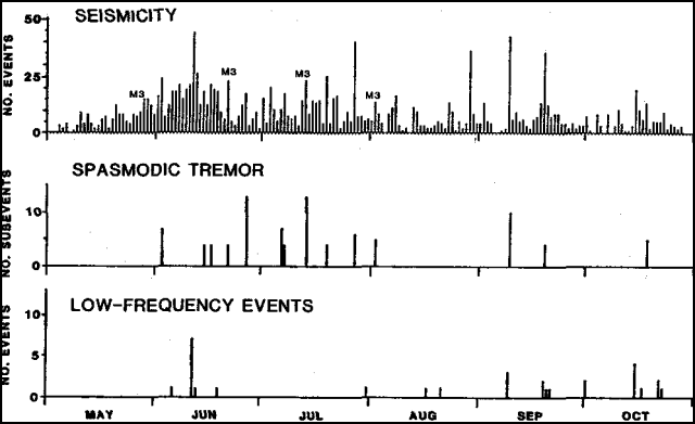 |
Figure 10. Number of local earthquakes/day top); spasmodic tremor episodes that included more than four sub-events middle; and number of low-frequency events bottom recorded by the California Division of Mines and Geology NEWT system, 4 May-30 October, 1989. Courtesy of Stephen McNutt. |
Relevelling of a line (along Rt. 203) a few kilometers N of the main epicentral area in late September yielded ~1.5 cm of relative uplift at its W end (Minaret summit) compared to summer 1988 values. New 2-color geodimeter sites on the E and N flanks of Mammoth Mountain that were surveyed in late August, late September, and about 10 November showed about four microstrain of NW-SE extension, parallel to the T axes of swarm focal mechanisms. These data were consistent with extension and uplift of the epicentral region. Preliminary data also suggest increasing dilatation across the resurgent dome in recent months, and seismic instruments have detected a few small (magnitude less than or equal to 2) earthquakes in the caldera's W moat.
Geological Summary. The large 17 x 32 km Long Valley caldera east of the central Sierra Nevada Range formed as a result of the voluminous Bishop Tuff eruption about 760,000 years ago. Resurgent doming in the central part of the caldera occurred shortly afterwards, followed by rhyolitic eruptions from the caldera moat and the eruption of rhyodacite from outer ring fracture vents, ending about 50,000 years ago. During early resurgent doming the caldera was filled with a large lake that left strandlines on the caldera walls and the resurgent dome island; the lake eventually drained through the Owens River Gorge. The caldera remains thermally active, with many hot springs and fumaroles, and has had significant deformation, seismicity, and other unrest in recent years. The late-Pleistocene to Holocene Inyo Craters cut the NW topographic rim of the caldera, and along with Mammoth Mountain on the SW topographic rim, are west of the structural caldera and are chemically and tectonically distinct from the Long Valley magmatic system.
Information Contacts: S. McNutt, California Division of Mines and Geology, Sacramento; D. Hill, USGS Menlo Park.