Report on Whakaari/White Island (New Zealand) — December 1989
Scientific Event Alert Network Bulletin, vol. 14, no. 12 (December 1989)
Managing Editor: Lindsay McClelland.
Whakaari/White Island (New Zealand) Mild explosions; new crater enlarged
Please cite this report as:
Global Volcanism Program, 1989. Report on Whakaari/White Island (New Zealand) (McClelland, L., ed.). Scientific Event Alert Network Bulletin, 14:12. Smithsonian Institution. https://doi.org/10.5479/si.GVP.SEAN198912-241040
Whakaari/White Island
New Zealand
37.52°S, 177.18°E; summit elev. 294 m
All times are local (unless otherwise noted)
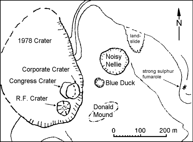
Only mild eruptive activity has occurred since 11 October fieldwork revealed a possible new vent in Congress Crater. During a 4 November overflight, pilot R. Fleming witnessed ejection of tephra above 1978 Crater rim, and Bruce Christenson observed new blocks there on 9 November. No new tephra were found on the main crater floor during 12 and 18 November visits, but the new vent, named Corporate Crater, was clearly visible for the first time.
During 29 November fieldwork, geologists observed small amounts of new ash on the main crater floor, and 35 mm of new fine ash on 1978 Crater rim. Ash-covered lithic blocks (up to 0.2 m) had been ejected to 50 m from the E crater rim. Block distribution indicated a source in Corporate Crater (figure 12), now a deep vertical-walled pit that has grown to occupy the E half of Congress Crater. The remnant of Congress Crater's flat floor had been built up by ejecta and talus that infilled previously active Hitchhiker Vent. Scoriaceous bombs were found in the S part of the clast field, suggesting a source from R.F. Crater, which appeared unchanged since 11 October.
Most gas emissions originated from R.F. Crater, with a small amount of steam rising from Corporate Crater. Donald Duck vent emitted voluminous white clouds from active crater floor vents that had migrated NW. Noisy Nellie vent discharged a large volume of high-pressure clear gas.
Medium-frequency (3-4 Hz) volcanic tremor and rare small A-type events were recorded 11-14 October. Small A-types were the only clear events recorded 14 October- 21 November. Since 21 November, fewer than 5 small A- and/or B-type events/day have been recorded.
The 29 November deformation survey showed minor but uniform uplift of most of the main crater, reversing the strong subsidence (centered over Donald Mound) in the 10 weeks prior to 11 October. The inflation was interpreted as evidence of renewed heating at depth beneath Donald Mound, possibly the precursor of future increased activity from 1978 Crater. Magnetic data generally showed only small changes, suggesting modest shallow cooling that may have been associated with heavy recent rainfall.
Geological Summary. The uninhabited Whakaari/White Island is the 2 x 2.4 km emergent summit of a 16 x 18 km submarine volcano in the Bay of Plenty about 50 km offshore of North Island. The island consists of two overlapping andesitic-to-dacitic stratovolcanoes. The SE side of the crater is open at sea level, with the recent activity centered about 1 km from the shore close to the rear crater wall. Volckner Rocks, sea stacks that are remnants of a lava dome, lie 5 km NW. Descriptions of volcanism since 1826 have included intermittent moderate phreatic, phreatomagmatic, and Strombolian eruptions; activity there also forms a prominent part of Maori legends. The formation of many new vents during the 19th and 20th centuries caused rapid changes in crater floor topography. Collapse of the crater wall in 1914 produced a debris avalanche that buried buildings and workers at a sulfur-mining project. Explosive activity in December 2019 took place while tourists were present, resulting in many fatalities. The official government name Whakaari/White Island is a combination of the full Maori name of Te Puia o Whakaari ("The Dramatic Volcano") and White Island (referencing the constant steam plume) given by Captain James Cook in 1769.
Information Contacts: I. Nairn, NZGS Rotorua.


