Report on Okmok (United States) — 9 July-15 July 2008
Smithsonian Institution / US Geological Survey
Weekly Volcanic Activity Report, 9 July-15 July 2008
Managing Editor: Sally Sennert.
Please cite this report as:
Global Volcanism Program, 2008. Report on Okmok (United States) (Sennert, S, ed.). Weekly Volcanic Activity Report, 9 July-15 July 2008. Smithsonian Institution and US Geological Survey.
Okmok
United States
53.43°N, 168.13°W; summit elev. 1073 m
All times are local (unless otherwise noted)
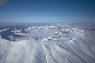
A strong explosive eruption at Okmok began abruptly at 1143 on 12 July after about an hour of rapidly escalating earthquake activity. Ash and gas from the initial explosions reached at least 15 km (50,000 ft) a.s.l on 12 July and drifted as a large cloud S and E above the North Pacific. Satellite tracking of the ash cloud by traditional techniques has been hampered by the high water content due to interaction of rising magma with very shallow groundwater and surficial water inside the caldera. Heavy ashfall occurred on the eastern portion of Umnak Island; a dusting of ash also occurred for several hours in Unalaska/Dutch Harbor.
As of 15 July, based on AVO analysis of satellite data, ash is continuing to erupt from a composite cinder and spatter cone called Cone D in the eastern portion of the 6-mile wide caldera. Seismicity reached a peak at about 1400 on 12 July and has been gradually declining since. The volcano is currently at aviation color code RED and alert level WARNING. All areas immediately around the volcano are considered hazardous.
News media reported that residents of Umnak Island heard thundering noises the morning of 12 July and quickly realized an eruption had begun. After calling the US Coast Guard for assistance, they began to evacuate to Unalaska using a small helicopter. A fishing boat evacuated the remaining residents after heavy ashfall made further flights impossible.
Geological Summary. The basaltic Okmok shield volcano forms the NE end of Umnak Island in the Aleutian Islands. The summit of the low, 35-km-wide volcano is cut by two overlapping 10-km-wide calderas formed during eruptions about 12,000 and 2,050 years ago when dacitic pyroclastic flows reached the coast. More than 60 tephra layers from Okmok have been found overlying the 12,000-year-old caldera-forming tephra layer. Numerous cones and lava domes are present on the flanks down to the coast, including the SE-flank Mount Tulik, which is almost 200 m higher than the caldera rim. Some of the post-caldera cones show evidence of wave-cut lake terraces; more recent cones were formed after the caldera lake, once 150 m deep, disappeared. Eruptions have been reported since 1805 from cinder cones within the caldera, where there are also hot springs and fumaroles.
Sources: Associated Press, US Geological Survey Alaska Volcano Observatory (AVO)