Report on Okmok (United States) — 20 August-26 August 2008
Smithsonian Institution / US Geological Survey
Weekly Volcanic Activity Report, 20 August-26 August 2008
Managing Editor: Sally Sennert.
Please cite this report as:
Global Volcanism Program, 2008. Report on Okmok (United States) (Sennert, S, ed.). Weekly Volcanic Activity Report, 20 August-26 August 2008. Smithsonian Institution and US Geological Survey.
Okmok
United States
53.43°N, 168.13°W; summit elev. 1073 m
All times are local (unless otherwise noted)
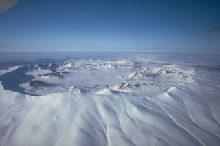
AVO reported that seismic activity at Okmok decreased on 19 August to near pre-eruption levels and remained low during 20-24 August. Occasional bursts of volcanic tremor were detected. Although satellite views were hindered due to cloud cover, a possible thermal anomaly in the crater was present on 21, 24, and 25 August. The Volcano Alert Level remained at Watch and the Aviation Color Code at Orange.
Geological Summary. The basaltic Okmok shield volcano forms the NE end of Umnak Island in the Aleutian Islands. The summit of the low, 35-km-wide volcano is cut by two overlapping 10-km-wide calderas formed during eruptions about 12,000 and 2,050 years ago when dacitic pyroclastic flows reached the coast. More than 60 tephra layers from Okmok have been found overlying the 12,000-year-old caldera-forming tephra layer. Numerous cones and lava domes are present on the flanks down to the coast, including the SE-flank Mount Tulik, which is almost 200 m higher than the caldera rim. Some of the post-caldera cones show evidence of wave-cut lake terraces; more recent cones were formed after the caldera lake, once 150 m deep, disappeared. Eruptions have been reported since 1805 from cinder cones within the caldera, where there are also hot springs and fumaroles.
Source: US Geological Survey Alaska Volcano Observatory (AVO)