Report on Chachadake [Tiatia] (Japan - administered by Russia) — 9 June-15 June 2010
Smithsonian Institution / US Geological Survey
Weekly Volcanic Activity Report, 9 June-15 June 2010
Managing Editor: Sally Sennert.
Please cite this report as:
Global Volcanism Program, 2010. Report on Chachadake [Tiatia] (Japan - administered by Russia) (Sennert, S, ed.). Weekly Volcanic Activity Report, 9 June-15 June 2010. Smithsonian Institution and US Geological Survey.
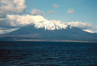
Chachadake [Tiatia]
Japan - administered by Russia
44.353°N, 146.252°E; summit elev. 1822 m
All times are local (unless otherwise noted)
SVERT reported that a thermal anomaly from Tiatia was detected by satellite on 10 June. Tiatia does not have a seismic network; satellite image observations are the primary tool for monitoring many of the Kurile Islands volcanoes.
Geological Summary. The symmetrical Chachadake, also known as Tiatia, is on the SE side of northern Kunashir Island in the southern Kuriles. The active cone rises above the rim of a filled 2.1 x 2.4 km summit caldera with erosionally furrowed flanks. The central cone, mostly formed by basaltic to basaltic andesite Strombolian eruptions, rises 400 m above the floor of the caldera and contains a 400 x 250 m wide crater with two explosion vents separated by a linear septum. Fresh lava flows cover much of the SW caldera floor and have overflowed the rim, extending to the foot of the older edifice, which formed during the late Pleistocene or early Holocene. A 500-m-wide crater about 2 km down the SE flank from the caldera rim is surrounded by an unvegetated area of volcanic deposits. The first recorded eruption was in 1812, and a major explosive eruption with lava flows in 1973 originated from vents on the central cone.